Izu Peninsula
photo-shutterstock.By ThePonAek
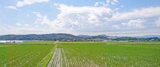
Izu Peninsula (Izu Hanto), a resort about 100 kilometers southwest of Tokyo, is famous for its hot springs, beautiful coastlines, beaches, mild climate and stunning views of Mount Fuji from the west coast.
How to get to Izu Peninsula from Tokyo:
JR Tokaido Shinkansen Tokaido express train connects Tokyo and Atami Station (40-50 minutes) and Mishima Station (45-60 minutes) or by regular train on this line (100 minutes).
Limited express train Odoriko/Odoriko, connects Tokyo and Shinjuku stations with Atami (80 minutes), Ito (100 minutes) and Shimoda Izukyu (160 minutes) in the south of the Izu Peninsula.
From Hakone, you can first go to Odawara Station and then to Atami in 23 minutes by bullet train.
Getting around the Izu Peninsula:
Many Japanese or European-style hot spring hotels are located on the Pacific coast near Atami Station. It is possible to travel around the peninsula by train, bus or rented car. There are two local trains per hour in each direction between Atami and Shimoda (90 minutes). There are three to four trains per hour in each direction from Mishima to Shuzenji (30 minutes). Most areas of the Izu Peninsula and major train stations such as Atami, Ito, Shuzenji and Shimoda are connected by Tokai buses. Payment depends on the distance traveled and is made at the exit.
The Izu Peninsula (Izu Hanto) is a resort about 100 kilometers southwest of Tokyo, famous for its hot springs, beautiful coastlines, beaches, mild climate and stunning views of Mount Fuji from the west coast.
Atami is a city with hundreds of comfortable hotels and ryokans, located on steep slopes along the ocean coast. From Atami Pier, ferries regularly go to Hatsushima Island, a cozy seaside resort surrounded by subtropical flora. The symbol of the resort town is a hot geyser gushing out of the ground in the park in front of the city station. From Tokyo by high-speed train 40-50 minutes. One of the best private museums in Japan, the MOA Museum of Art, is located here. There is also a unique museum of erotica, to which entry to people under 18 is prohibited.
Ito is another famous hot spring town along the eastern coast of the Izu Peninsula, located approximately 15 kilometers south of Atami. Within Ito is the resort town of Izu Kogen with a large number of hot springs and the beautiful coastline of Zogasaki. Ito is a 100-minute limited express train ride from Tokyo. Ito is famous for its Komuroyama Park, located on the slopes of the dormant Omuro volcano, Lake Ippeki of volcanic origin, whose waters reflect the Amagi Mountains, and the Tropical Crocodile Park. For art lovers, Ito provides the opportunity to get acquainted with the rich collection (about 1200 canvases) of paintings by Matisse, Picasso, Chagall, Dali and other European masters at the Ikeda Museum.
Shimoda, the southernmost part of the peninsula, is famous not only for its white beaches, but also as the place where Commodore Perry's Black Ships first landed in 1854, this important event marked the end of Japan's era of self-isolation and the beginning of diplomatic relations between the United States and Japan. Guests come to admire the views from Cape Iro and relax on Shirahama Beach.
Shuzenji Hot Spring Resort in central Izu is a famous hot spring resort named after a local temple. Shuzenji Temple was founded approximately 1,200 years ago by the monk Kobo Daishi (Kukai), one of Japan's most important religious figures. There are several ryokan - Japanese-style hotels - where not only guests, but also guests of this cute hot spring town can take a dip in the onsen. You can get to Chuzenji from Tokyo from Mishima Station (30 minutes, 500 yen) and upon arrival at the station, take a bus to the hot spring area (7 minutes, 210 yen). Both high-speed and regular trains depart from Tokyo to Mishima Station (45-60 minutes).
Kawazu Nanadaru is the site of seven waterfalls in the mountains above the city of Kawazu in the southeastern part of the Izu Peninsula. At the foot of the largest Kawazu Falls, hot springs emerge to the surface, water from which flows at a rate of 620 liters per minute, with a surface temperature of 38-49 degrees, which allows you to plunge into real thermal springs in the open air with a view of the waterfall. A 25-minute drive from Nanadaru Kawazu is Kawazu Station, where visitors come to admire it from late February to mid-March. In Kawazu, cherry blossom trees bloom early and the Kawazuzakura festival takes place here. A breathtaking landscape of cherry blossoms awaits guests along the banks of the river for four kilometers.
Islands
The Izu archipelago consists of the following islands:
| № | Photo | Name (Russian) | Title (Japanese) | Area, km² | Population, people (2007) | Highest point, m | Name of the highest point | Coordinates |
| 1 | Izuoshima | 伊豆大島 | 91,06 | 8472 | 764 | Mihara | 34°44′ N. w. 139°24′ E. Longitude / 34.733°N w. 139.400° E. d. / 34.733; 139.400 (G) [www.openstreetmap.org/?mlat=34.733&mlon=139.400&zoom=14 (O)] (I) | |
| 2 | Toshima | 利島 | 4,12 | 304 | 508 | Miyatsuka | 34°31′ N. w. 139°17′ E. long / 34.517° north w. 139.283° E. d. / 34.517; 139.283 (G) [www.openstreetmap.org/?mlat=34.517&mlon=139.283&zoom=14 (O)] (I) | |
| 3 | Udoneshima | 鵜渡根島 | 0,4 | —1) | 210 | 34°28′21″ n. w. 139°17′38″ E. d. / 34.47250° n. w. 139.29389° E. d. / 34.47250; 139.29389 (G) [www.openstreetmap.org/?mlat=34.47250&mlon=139.29389&zoom=14 (O)] (I) | ||
| 4 | Niijima (with Hanshima and Jinai-to islands) | 新島 | 23,53 | 2420 | 432 | Miyatsuka | 34°22′ N. w. 139°16′ E. Longitude / 34.367°N w. 139.267° E. d. / 34.367; 139.267 (G) [www.openstreetmap.org/?mlat=34.367&mlon=139.267&zoom=14 (O)] (I) | |
| 5 | Shikinejima | 式根島 | 3,9 | 600 | 109 | Kambiki | 34°19′ N. w. 139°13′ E. Long / 34.3250° N w. 139.217° E. d. / 34.3250; 139.217 (G) [www.openstreetmap.org/?mlat=34.3250&mlon=139.217&zoom=14 (O)] (I) | |
| 6 | Kozushima | 神津島 | 18,87 | 1914 | 574 | Tenjo-zan | 34°13′ N. w. 139°09′ E. long / 34.217° north w. 139.150° E. d. / 34.217; 139.150 (G) [www.openstreetmap.org/?mlat=34.217&mlon=139.150&zoom=14 (O)] (I) | |
| 7 | Miyakejima | 三宅島 | 55,48 | 2382 | 815 | Oyama | 34°05′ N. w. 139°32′ E. long / 34.083° north w. 139.533° E. d. / 34.083; 139.533 (G) [www.openstreetmap.org/?mlat=34.083&mlon=139.533&zoom=14 (O)] (I) | |
| 8 | Onoharajima | 大野原島 | 0,02 | — | 114 | Koyasu | 34°02′53″ n. w. 139°23′02″ E. d. / 34.04806° n. w. 139.38389° E. d. / 34.04806; 139.38389 (G) [www.openstreetmap.org/?mlat=34.04806&mlon=139.38389&zoom=14 (O)] (I) | |
| 9 | Mikurajima | 御蔵島 | 20,58 | 313 | 851 | Oyama | 33°52′ N. w. 139°36′ E. long / 33.8750° north w. 139.600° E. d. / 33.8750; 139.600 (G) [www.openstreetmap.org/?mlat=33.8750&mlon=139.600&zoom=14 (O)] (I) | |
| 10 | Inambajima | 藺灘波島 | 0,005 | — | 74 | 33°38′53″ n. w. 139°18′08″ E. d. / 33.64806° n. w. 139.30222° E. d. / 33.64806; 139.30222 (G) [www.openstreetmap.org/?mlat=33.64806&mlon=139.30222&zoom=14 (O)] (I) | ||
| 11 | Hachijojima | 八丈島 | 69,54 | 8363 | 854 | Nishiyama (Hachijo-Fuji) | 33°07′ N. w. 139°47′ E. long / 33.117° north w. 139.783° E. d. / 33.117; 139.783 (G) [www.openstreetmap.org/?mlat=33.117&mlon=139.783&zoom=14 (O)] (I) | |
| 12 | Hachijokojima | 八丈小島 | 3,08 | —2) | 616,8 | Taihei-san | 33°07′31″ n. w. 139°41′18″ E. d. / 33.12528° n. w. 139.68833° E. d. / 33.12528; 139.68833 (G) [www.openstreetmap.org/?mlat=33.12528&mlon=139.68833&zoom=14 (O)] (I) | |
| 13 | Aogashima | 青ヶ島 | 5,98 | 192 | 423 | Maruyama (O-Toppu) | 32°27′29″ n. w. 139°46′04″ E. d. / 32.45806° n. w. 139.76778° E. d. / 32.45806; 139.76778 (G) [www.openstreetmap.org/?mlat=32.45806&mlon=139.76778&zoom=14 (O)] (I) | |
| 14 | Beyonesu Rocks | ベヨネース列岩 | 0,01 | — | 9,9 | 31°53′14″ n. w. 139°55′03″ E. d. / 31.88722° n. w. 139.91750° E. d. / 31.88722; 139.91750 (G) [www.openstreetmap.org/?mlat=31.88722&mlon=139.91750&zoom=14 (O)] (I) | ||
| 15 | Sumisu | 須美寿島 | 0,02 | — | 136 | 31°26′13″ n. w. 140°02′49″ E. d. / 31.43694° n. w. 140.04694° E. d. / 31.43694; 140.04694 (G) [www.openstreetmap.org/?mlat=31.43694&mlon=140.04694&zoom=14 (O)] (I) | ||
| 16 | Panafidina Island (Torishima) | 鳥島 | 4,79 | —3) | 394 | Io-zan | 30°28′48″ n. w. 140°18′22″ E. d. / 30.48000° n. w. 140.30611° E. d. / 30.48000; 140.30611 (G) [www.openstreetmap.org/?mlat=30.48000&mlon=140.30611&zoom=14 (O)] (I) | |
| 17 | Sofu-willow | 孀婦岩 | 0,005 | — | 99 | 29°47′39″ n. w. 140°20′31″ E. d. / 29.79417° s. w. 140.34194° E. d. / 29.79417; 140.34194 (G) [www.openstreetmap.org/?mlat=29.79417&mlon=140.34194&zoom=14 (O)] (I) | ||
| Izu Islands | 伊豆諸島 | 301,39 | 24960 | 854 | Nishiyama (Hachijo-Fuji) | 34°44′00″ n. w. 139°24′00″ E. long / 34.73333° north w. 139.40000° E. d. / 34.73333; 139.40000 (G) [www.openstreetmap.org/?mlat=34.73333&mlon=139.40000&zoom=14 (O)] (I) |
1) - currently uninhabited, the population existed on it during the Meiji era 2) - currently uninhabited, was inhabited until 1969 (31 people at that time, the largest population ever was 513 people) 3) - currently uninhabited for a time, was inhabited until 1902 (150 people, all died in a volcanic eruption)
Izuoshima Island is the northernmost in the island chain, the largest and most populated among the Izu Islands. The place is visited by tourists thanks to the Mihara volcano located on it (758 meters high). The second largest is Hachijojima Island. During the Edo period, some islands of the archipelago (Miyakejima, Hachijojima) were places of exile for criminals. In 2000, due to a possible eruption of Mount Oyama, about 3,000 residents were evacuated from the island of Miyakejima. In the summer of 2005, most of them returned.
Administrative subordination
- Oshima County Izuoshima
- Toshima
- Niijima (with neighboring islands Hanshima and Jinaito), Shikinejima, Udoneshima
- Kozushima
- Miyakejima and Onoharajima
- Hachijokojima
| : Incorrect or missing image | This article lacks links to sources of information. Information must be verifiable, otherwise it may be questioned and deleted. You may edit this article to include links to authoritative sources. This mark is set May 13, 2011 . |
K:Wikipedia:Articles without sources (type: not specified)