Basic methods for determining depth
There is no doubt how important it is to find that treasured area among the bottom topography that can bring the desired prey. But there are often cases when inexperienced fishermen, unable to set the required depth on match equipment, abandon it forever
A completely opposite example, when it seems that in the middle of a flat bottom you can find a small depression that attracts fish. And then, to the envy of others, the bites come one after another.
The line is passed through the marker weight ring and tied to the float. After the load falls on the ground, the float is attracted to it. By manually pulling the line from the reel to the marked mark or ring on the rod until the float floats up, we can easily calculate the depth.
It is worth noting that this method is not very suitable for fast currents, since the float is carried down. Due to the fastening at the bottom point, it floats up at an angle and is practically invisible. When the line is pulled up, it completely goes under water.
During the current, you can use another method for determining the depth. This is done like this:
- after throwing the load, we read the time it reaches the ground;
- make two turns with the reel, hook the cord to the clip;
- we wind up the tackle and throw it again to the clip, also counting the time;
- repeating the steps, we calculate the relief.
Unfortunately, using this method it is impossible to calculate which bottom is rocky, sandy, clayey, and so on. And it takes quite a lot of time to take measurements. For example, if you need to study the terrain at a distance of thirty meters, you need to make about fifteen measurements. If each one takes within a couple of minutes, it’s not difficult to calculate the time spent.
We set the Wagler to a maximum depth of 3 meters. We pull the line until the float floats up, and make a mark with a marker. We lower the waggler half a meter and again cast at the marker. The float, naturally, does not float up, so we pull up the line again. In this way you can measure the depth over the entire fishing distance.
We can agree that all of the above manipulations take a lot of time, sometimes at least an hour. The same distance has to be rechecked more than once, and in general more than a hundred meters have to be explored. But measuring the depth during match fishing will more than pay for all the costs if you find a catchable place, especially if you have to fish here more than once.
Task one: determine the “fishing spot”
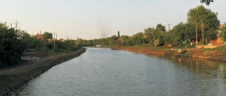
First you should find places where there are irregularities, edges and leveled shelves. You should look for fish where you think they would like to be. Understanding at what point the fish congregate on the bottom is very important for fishing. On small bodies of water, pay attention to some external features: islands of vegetation, coastal thickets. On larger lakes, finding a suitable spot may take some time. And fishing in an unfamiliar place is always interesting!
You should definitely make sure that familiar and trusted places remain there. Even if you know that the two edges were located very close, it would be a good idea to check: you never know what has happened to the bottom since your last visit :-/! Sometimes you need to make sure that the shelf is within reach of the plug rod, because due to its length limitation, you may simply not reach the bottom! It makes sense to check a few meters from the main point - suddenly there will be an opportunity to put bait nearby. And, of course, carefully remember and study the surrounding area: you need to remember each planned fishing point. Now it's time to move on to the next stage.
Counting the depth
The simplest, but at the same time longer, is measuring the depth on the count. How to do it? In addition to the feeder and weight, we will also need a pen, paper and, possibly, a stopwatch. First, we throw the weight as far as possible. We cast and as soon as the weight touches the surface of the water we begin to count, making sure that the rod is pointing upward. We count and wait for the tip to play. At the moment the tip is played back, we finish counting. We write down the result on a piece of paper. Next, we make three turns of the coil and clip the fence. We begin to unwind the equipment and at the same time count the number of revolutions of the reel. Opposite the result that we wrote down at the beginning, we put the number of calculated revolutions. We make the next cast with such force that the fence is exhausted to the clip. The weight touches the bottom surface and we start counting again. The result was again written down on paper. We try to count once every half second. Some people think even faster. Let's just say that the faster the count, the more accurate the readings will be. As you might guess, the score means the depth at the point where the weight falls. The longer it falls, the greater the depth in this place. Again we make three turns of the reel after the weight lands and clip it. Yes, an important point. If we have braid on the reel, then the moment the tip is played back is more noticeable than if there was fishing line on the reel
And it is also very important to keep the rod parallel to the shore when casting, and when the weight touches the surface of the water, you need to slightly raise the rod. This process will take approximately 15-20 minutes, depending on how far you throw the weight
Experience suggests that we measure the depth until no more than 20 turns of the line remain on the reel. If there is no hole near the shore, then they usually do not catch at such a distance. We make notes in a column and then use them to create a graphic display of the depth. On the vertical axis we will have depth, and on the horizontal axis we will have the number of revolutions. We put points on the graph and connect them with a line. As a result, we get a bottom topography. In the figure it might look like this:
Counting was carried out twice per second. If it were done more often, then, for example, the beginning of the tables, channel edges would be clearly counted at 11, 13, or 14. If difficulties arise with the count, it is better to use a stopwatch on your mobile phone. Only in this case will you need a mount on the rod to securely fix the phone. What do we see in this image? We see sharp changes in depth from 4 to 5.5 and from 5.5 to 6.5, as well as from 7 to 5. In the first case there is a dump or the first edge, and in the second we have a classic channel edge. In areas with a sharp bottom drop, it sometimes makes sense to study the bottom in more detail. It makes sense to check the depth after each revolution. With the usual method, we check after three turns, and with a more detailed method, after one. Promising areas for fishing are indicated by arrows. This is a standard case when we have a pronounced coastal edge, in front of it there is a gradual decrease in the bottom and tables. The channel is located in the middle of the reservoir or a little closer to one of the banks. Returning to the topic, where is it better to cast, then in the morning and afternoon it is better to fish at the exit from the channel edge and on the second table behind the dump. And at night we catch on the first table. In general, this method of measuring the bottom can be called accurate, with some convention. What does it give? Firstly, you can get your own depth map for almost every body of water. Even if the river has a current, you will still get depth information if you use a heavy weight that will not be carried by the current. Secondly, you will always have at hand such visual drawings indicating perspective points. The next time you come to the reservoir, you will have basic information about the depth and you will only need to break through the main points and make sure that they have not changed. Thirdly, you can always measure the bottom when the fish are not biting. You can cast at different azimuths and deviations and get more detailed information about the depths. By compiling such maps for different places, you will fill your database with useful information. Upon arrival at the reservoir, you will not need to spend a lot of time scanning the bottom. Again, we take into account only the depth, without taking into account the structure of the bottom. We will look at how to read the bottom and identify shells, sand, silt and stones in another way - by dragging a weight along the bottom.
Why measure the depth?
Ask anyone who teaches newbies the basics of fishing what they teach them first, and the answer will most likely be how to study a fishing spot using a depth gauge.
For most, this looks like a deceptively simple, elementary action that we do before every fishing trip, regardless of whether the place is familiar or not... For me, I find this process quite complex. However, the result can be valuable information about your fishing spot... if, of course, you did everything right. The explanation for this finding consists of the following key points:
Choosing a fishing spot
First of all, you need to evaluate external signs, such as remains of traces of fishing by previous visitors:
- traces of the use of bait and lures;
- trampled grass;
- fire pits;
- remnants of bait and food packaging.
https://www.youtube.com/watch{q}v=5YFQNRXHTSY
Having chosen a place based on external features, you should find out the nature of the bottom and depth at the intended fishing site.
It is known that fish love exotic things. That is, those places that are somehow different from the surrounding reality. Since the feeder is primarily gear for the current, by “reality” we mean the river. It is impossible to list all possible options for all rivers and for all cases, so we will only indicate the path for “great thoughts”, and the rest is a matter of creativity.
Riverbed
The channel is easy to determine by the buoys marking the fairway. If the river is not navigable and there are no buoys, then the channel runs closer to the steep bank than to the flat one. If the banks are the same, then closer to the right bank (due to Coriolis acceleration for the northern hemisphere). In a river bend, the channel is closer to the outer bank of the bend. From the side of the gently sloping bank there may not be an edge of the channel; the depth will simply gradually increase.
Current speed
The speed of the current increases where the river narrows. If the current speed does not noticeably increase here, it means that the depth here is increasing. If the speed of the current increases without narrowing the river, it means that the depth here is decreasing. The faster surface current stripe on the surface of the river shows where the channel lies. In calm weather, an area with constant ripples in the water shows a sandbar. A section of the channel with a slower flow shows a hole.
Other signs
The clayey part of the bottom, as a rule, is deeper than the rocky one, and the sandy part is deeper than the clayey one. Below rifts, channel banks, artificial structures (bridge supports, stone embankments, etc.), as a rule, holes form. The turbulence of the current away from the channel also indicates a hole. Air bubbles coming to the surface in the same place indicate the presence of a spring. Promising places are also the mouths of flowing rivers and streams.
Having assessed the situation and made a decision, we begin to study the topography and bottom structure in the chosen location. The most accurate way to study the underwater environment is the method shown in photo 1. But in real life you have to be content with simpler, but also less accurate techniques.
It has been noticed that bottom fish prefer those areas of the bottom where there are some pronounced heterogeneities. These are holes, changes in depth, ledges on slopes, boundaries of a pebble bottom with a sedimentary bottom, a sedimentary bottom with algae, open areas of the bottom among algae, etc. In a word, everything that somehow contrasts with its surroundings. Our task is to find these areas (Fig. 1).
How to determine the depth of a reservoir
Experienced fishermen know that fishing success depends on many factors, both objective and subjective. Subjective reasons for the lack of bite include incorrect choice of fishing location due to inattention to the topography and structure of the bottom surface. If you neglect to determine the depth of an unfamiliar body of water, a good catch will be more likely a consequence of chance than a tribute to the skill of the fisherman. And an accident, especially a pleasant one, cannot repeat itself endlessly!
The topic of our conversation today will be the most popular methods of measuring depths. Some of them are easy to implement at minimal cost, but are not very accurate. Others allow measurements to be made with virtually no error, but require a lot of effort or financial costs from the fisherman. Which one to choose is up to you. Surely, as you gain practice, you will find the best option for yourself, for a specific body of water and equipment.
- Why do you need to take measurements?
- Manual methods of sounding depths
- Marker float
- Tapping with a load
- Stepped wiring
- Combinations with drawing
- Use of the lot
- Measuring depths using an echo sounder
- Angling tips
Measuring the depth with the feeder in the video. Tips from Vitaly Kolganov
: 21.01.2017
Vitaly Kolganov has released a good series of films about studying the bottom of various bodies of water. The bottom topography and methods for finding the best point differ in reservoirs without a current, rivers and artificial canals. With knowledge and experience, you can find the optimal fishing spot almost anywhere.
The correct feeding point is one of the basics of feeder fishing. Having several sinkers and different methods of using them, you can quite accurately understand what is on the bottom and choose the right feeding tactics.
How to measure the bottom with silt?
For the first video, Vitaly chose a small pond with standing water. In this video he explains the basics of measuring muddy bottoms. Uses different methods of studying with a sinker and using the Dipper Pro+ echo sounder. Muddy pond. Measuring the bottom with a feeder.
What weights are used for measuring the bottom?
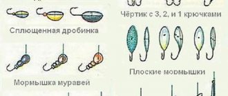
Most often the shape is a drop, an olive or a marker weight. Their weight is 30, 56 and 112g. One weight is suitable for weak currents, the other for strong ones. In addition, weights of different weights signal differently the state of the bottom (silt, shell, sand, etc.).
What is the principle of bottom sounding?
Dragging We throw out the feeder and smoothly drag the weight along the bottom. As a rule, in a body of water with standing water, the bottom is smooth and covered with silt. The weight goes along the bottom with some effort and almost the same. The bottom of such reservoirs most often does not have sharp changes. It is covered with silt and carp and crucian carp live well on them.
In the case of a muddy bottom, is it difficult to find a good fishing spot by dragging a weight? Tapping the bottom is better for this.
Tapping the bottom Throw in the weight. When it touches the water, we begin to count until the weight falls to the bottom. Let's remember the score. We reel in the fishing line with 2 turns. We put the braid into the clip. We cast again and count. Etc.
This is how we see how the bottom depth behaves in a muddy reservoir. Decreases, increases or does not change (table). We have tightened the braid in the clip several times, and by releasing it, we can return to the desired depth.
So, by composing the bottom topography for yourself, you can decide on the best point and feed it. This could not be done by dragging a weight.
Where is the best place to fish if there is silt at the bottom?
As a rule, such reservoirs are of shallow depth. And with intensive feeding with a feeder feeder, the fish does not approach the equipment for some time. Therefore, it is better to come to such reservoirs and feed them early. It is better to choose a point for feeding on the table (a period of constant depth).
How to study the bottom of a river with a small current?
In the second video, Vitaly Kolganov studies the bottom with a feeder on the river. For this he chose the Moscow River in the upper reaches. River with a weak current
As a rule, it is easier to study the bottom on a river. For medium flow, a 56g weight is suitable. We make a long cast. And by dragging the load we look for a drop in the bottom (edge). The tip of the feeder gives a good indication of the bottom surface. Silt, shell, sand are clearly visible.
Most often, on a “classic” river, after the first casts you can find an edge and decide on the feeding point with a feeder feeder. On a familiar river, feeder lovers don’t even use a weight for tapping, but use a feeder to look for the edge and clip.
Determining the fishing point on a river with a medium current
The third video is about how to find a fishing point on a channel with a medium current. For practice, Vitaly chose the channel named after. Moscow.
Medium current
To begin with, we use a 56g weight. By simply dragging, you can roughly determine the characteristics of the bottom. If such weight is carried away by the current, then the load is placed more.
By dragging you can feel the bottom well. The tip of the feeder bends smoothly as the silt passes and “knocks” if there is a shell at the bottom.
On the river, they often feed not on the edge, but in front of it!
Such steps in front of the edge are not uncommon. And it is precisely feeding such a point that gives the best results.
Difficult bottom topography. How to decide on a feeding point if the bottom is flat?
For this video, Vitaly chose a complex body of water to study. Rowing channel. There is no bright edge or depth difference on it. The more interesting it is for learning.
A difficult bottom without significant changes in depth Vitaly clearly shows how, even under such conditions, you can find a suitable point for feeding fish. Muddy bottoms are always difficult to work with. The feeder does not register any special relief. In this case, a combination of different methods of studying the bottom is suitable.
Measuring the depth and topography of the bottom before fishing with a feeder: where to start
Content
Correctly determining the nature of the bottom before fishing is an important component of a rich catch. An important question is of great importance, lies on the same plane in parallel with other aspects: how to find a promising place for fishing, know about the habits of fish, taste preferences in a specific period of time, standing on the shore. Scanning with a marker weight is relatively quick and quite simple. Any beginner in the field of fishing with a float or feeder can successfully cope with this task. There are no difficult moments in the process of determining the bottom topography.
Before measuring the depth with a feeder or marker weight, you should carefully prepare for fishing at home. Experienced catchers make the device with their own hands, use their own know-how, and do not use the services of retail chains. Beginners can be advised to buy the necessary device, and when they gain experience, use it in practice. Usually such a load is a ball, a bullet, a bomb with stabilizers at the edges. A very good shape for studying the nature of the bottom with maximum sensitivity and great chances of long casting.
It has been noticed that bottom fish prefer those areas of the bottom where there are some pronounced heterogeneities
What is an "edge"
Those who are not familiar with the terminology and have not encountered the concept of a river edge should figure out what it is.
In places where fast currents or strong turbulences of the flow wash away soil from the bottom, the depth of the river changes. Sometimes the bottom goes down slowly, almost imperceptibly, sometimes it ends abruptly. The slope is called a slope, the flat parts are called a table, and the places where the breaks are called edges. Some call the entire slope the edges, but this is incorrect.
Eyebrows are distinguished according to the following main characteristics:
By location relative to the water surface:
- The upper one is closer to the surface of the water, it marks the transition from a flat table to the beginning of the drop;
- The lower one, accordingly, is located lower, where the slope goes back into the table or shelf, if there are several height differences.
By distance from the coast:
- Beregovaya – located closest to the shore;
- Channel - frames the edges of the channel.
When the water is warm, fish accumulate near the shoreline. It is convenient because it has access from the shore. Later, with the arrival of cold weather, the fish go to feed deeper, to the riverbed edges.
Depending on whether it belongs to one of the elements of the bottom topography, the edge can be:
- part of a ditch;
- part of the pit.
Sometimes the current creates oblong depressions - ditches. Of these, the channel one, located in the center of the stream, is at the lowest point. In fact, this is an additional deepening in the riverbed. Those that appear closer to the banks are near the riverbed, higher. They are much smaller in size. A short riverbed ditch is often considered a pit. It is only possible to accurately determine the size using an echo sounder.
The edge of the river is not always a straight, even line. There are parts protruding into the channel. They are called "tongues". The bends towards the shore were given the nickname "pocket".
Rivers are mobile; currents, channel locations, and bank boundaries change over time. Consecutive depth differences are formed. Then you get whole ladders of steps, with horizontal sections - shelves. Medium-sized predators like pike, pike-perch or perch lurk here. The design of the shelves allows you to successfully lure fish onto the hook. But determining their location without available means is quite difficult.
Occasionally there are irrigations - smoothly rising wide areas between two edges or an edge and the shore.
Bottom irregularities are considered important for a reason. Small food accumulates on the sloped surface. It attracts small fish, which rush to collect food before it is carried away downstream. Small fish attract large predators. They hide in the depths and catch their food at the lower break. So, if a friend tells you that he caught a huge catfish on the edge, he is definitely talking about the bottom.
Much depends on the depth of the hole and the river itself. If the river itself is small, then you need to look for fish at the very bottom. If it is full-flowing, then the bends of the relief are interesting.
Catfish, bream, and large pike perch climb the lowest. Among the daredevils who get closer to the dump there are perch, pike, ide, roach, and small pike perch. Pike hunts at any time of the day; catfish and pike perch prefer the night. Good fishing spots are never empty, so there is often a queue.
Determining the bottom topography and its structure
At the moment, the most common way to determine the relief and structure of the bottom is using marker equipment with a sinker. It can be made at home. You need to take a marker sinker with spikes or protrusions, a steel leash, a pass ring on the leg (preferably with a ceramic layer inside), a bottle cap, a swivel, a snap hook, and a special float. The leash will protect your equipment from mechanical damage, the cork will help it float, and the line will glide much better in a ring with ceramics.
Currently, to determine the bottom relief and its features, fishermen use several methods and their combinations. Let's take a closer look at them.
Jig wiring
This method is easy to perform and requires only basic knowledge of jig fishing from the fisherman. The main condition for this is the uniformity of the wiring and its pace. From the moment the jerk is made until the subsequent fall of the sinker to the bottom, the fisherman counts the time as quickly as possible. The relief of the reservoir (holes, edges, etc.) will depend on the difference in the count in different areas. It is clear that if the count increases, then the depth in this area is greater, and vice versa.
Broaching method (drawing)
If the tip of the tackle trembles and ringing movements are heard in your hand, then it is clear that the bottom of the reservoir is pebbly. If nothing interferes with the passage of the weight, then there is a sandy bottom below, and in the case where the movements are dull, it is shell rock. With long jerks of the rig, there is algae in front of you. If the movements are light, even with some slack - a slope, and if the movement is tight - an ascent. In the case of drawing equipment, you only need a cord. Please note that a lot depends on the action of the rod: the faster it is, the more effectively you can examine the selected bottom relief. In sport fishing, ultra-fast marker rods are used for these purposes. However, for experienced fishermen there are no problems in measuring using almost any gear.
Marker float tackle
The line is then manually released from the reel. In this case, the fisherman needs to control the mark on the fishing rod (if a marker is used), or monitor the first ring. It is imperative to count how many bleeds are made before the float floats to the surface.
You can do the opposite: make the float float up, then wind the main line onto the spool until it stops, while counting the revolutions of the reel. Now all that remains is to drag the weight along the bottom relief for a few meters (in order to determine its structure), and measure the depth again.
This method is used by matchmakers. When fishing with a feeder in fast rivers, it is of little use due to the drift of the float by the current, and, as a result, incorrect results of your research.
Professional methods
It is possible to absolutely accurately calculate the aquifer when conducting geotechnical research. It is impossible to conduct such experiments on your own. To do this, you must have special knowledge and skills, as well as have the necessary equipment.
Services for studying the hydrogeological conditions of the area, determining the quantitative and qualitative assessment of water reserves are provided by specialized companies, one of whose areas of activity is engineering geology.
A promising method for finding the optimal location for drilling wells is hydrogeological surveying. This is what allows you to:
- discover aquifers;
- establish groundwater reserves.
Based on the results obtained, conclusions are drawn regarding the feasibility of drilling a well in the specified area.
There are other professional methods of geological exploration, which include:
- electrical sensing;
- seismic exploration;
- drilling of exploratory workings.
The only drawback of such methods of finding the best site for a well is the need to incur financial costs aimed at paying for the services provided by specialists.
For many, this circumstance is decisive in refusing to use such effective methods.
Counting method
But the easiest way to determine depth is the method used by many experienced spinners. This is a counting method: you need to count the seconds from the weight's contact with the water until it falls to the bottom in a given place. This is done simply: the weight is thrown into the point of the reservoir where you need to measure the depth. After touching the water surface (it is advisable that there is no slack on the line at this moment), you begin a second-by-second countdown: one, two, three, and so on. The end of the countdown is considered to be the moment when the line sag sharply. This means that the cargo has already landed on the bottom.
The best standard for such measurements is a weight or spoon weighing 17–22 grams, since in the water column they drop 1 meter in about 1 second. There will undoubtedly be an error with this method, but within 0.5 meters at a depth of 3 to 5 meters and about 1 meter at a depth of 6-10 meters.
Manufacturing process
https://youtube.com/watch?v=SnsdNgiF2r0
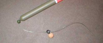
There is nothing complicated in making a marker float. What the equipment looks like is shown in the first picture. We repeat, any floating material can be used as a float.
Suitable floats:
- plastic jars or bottles for various medications;
- large floats for float fishing rods;
- float planed from wood;
- syringe float;
- any other non-sinking object.
You can buy a sinker in a store, you can buy it right away with an eye for threading the main line, or you can make a leash and tie a winding ring to the end of the leash, the main thing is that it is not too small and without burrs, so that the line passes smoothly under the action of the buoyant force applied to the float .
How to choose an echo sounder for fishing from the shore - the best models, prices and top echo sounder from the editors of EarlyUtrom.com. A video on how to determine the depth in a reservoir by ripples on the surface of the water. A complete guide to choosing an echo sounder is here.
A marker sinker, like a float, cannot be found in all stores, and sometimes the price for them is steep, so we, lovers of homemade products, will make them ourselves.
We take an olive sinker weighing one and a half ounces, which is approximately equal to 42 grams, and drill in it, in addition to the existing one, two more holes at an angle of 90 degrees. In the photo I marked these holes by inserting a toothpick into each. We carefully drill out each one several times, since chips from drilling one can clog the passage in the other.
Olive with holes
At the end of the soft knitting wire, I took a sparkler rod, made a small loop, then put on a small sliding weight, 6 grams, and our olive.
Start of installation
We put the second mini-weight on the other side of the large olive and cut off the wire with a small margin. We stretch the wire, inserting the first loop into the hole of the first mini-olive. We make a loop on the other side and insert it into our olive under tension.
The first line is assembled
Cross made of olive sinkers
We insert a rigid wire into the base of the structure, having previously twisted it. We put a heat shrink tube on this resulting vertical rod.
Rod, cross and tube
We cut the wire, leaving about ten centimeters. We make a loop at the end, put a heat-shrinkable tube on it, heat it with the flame of a match or lighter and fix it. The tube is put on to avoid overlap and line breakage.
Finished marker sinker
To make a marker float, take the feathers from a children's arrow and a tube from a flag.
Float materials
We insert the plumage into the tube. It turns out almost like a dart from a dart; by the way, the feathers of such darts can be cut off.
We select a swivel that matches the internal diameter of the tube and glue it in.
Swivel in a tube
We glue the fastening points with cyanoacrylate-based glue. Then we cover the blades of the float with multi-colored electrical tape for better visualization on the pond (I tried to cover it with fishing varnish - for some reason it didn’t stick, apparently the material of the blades was not the same).
This is what both hand-made marker equipment elements look like together.
Equipment: weight and float
The depth of the reservoir and its relief by ripples on the surface of the water
The depth of a river or any other body of water can be determined with relative accuracy by the nature of the ripples on the surface of the water.
It is best to carry out the analysis in the presence of a slight wind, or almost calm, so that in some areas of the reservoir there is a smooth surface, and in others there are small ripples.
The smooth surface of the water is the deepest parts of the reservoir.
Small ripples are smaller places compared to deep water, and the stronger the ripples, and in some places developing into waves and whitefish, the shallower the place.
Ripple Analysis Video
Watch the video and use a visual example to see how the depth in a reservoir is determined.
Source
Basic method (jigging)
The jig method of scanning the bottom is the main one. Amateur feeders must know a simple technique for studying a reservoir if they dream of becoming professionals in a difficult task.
There are plenty of advantages to this simple method:
- study in detail the depths in the designated area;
- actually thoroughly determine the relief;
- find out the structure of the soil;
- with a high probability of choosing a promising fishing spot.
Scanning with a jinning line is not difficult; you will need: a set of sinkers, a fishing rod, and the fisherman’s attentiveness to determine the moment the equipment touches the bottom.
Holding the end of the rod as low as possible, we pull the load along the bottom with the rod
It is advisable to divide the bottom exploration tactics into stages:
- The feeder throws the equipment to a given point and from the moment the marker touches the water - the marker reaches the bottom - remembers the time period.
- After the load lands, the fisherman jerks his rod upward. The concept is that the load should rise from the terrain after each movement of the fishing rod. Experienced anglers must time the drop of the sinker with each jerk, repeating the amplitude and strength of the exercise.
Bottom dragging method
Another method regarding the question of how to measure depth while fishing is dragging along the bottom. The tactics of use are based on determining the structure of the relief and are used at the final stage of studying the visually outlined zone of the intended catch of fish, when suitable places, differences, and thresholds are identified. The prospects for the chosen method are a high percentage of finding sandy, hard surfaces, algae, silt, shell shells, and pebbles.
Dragging tactics involve the use of a heavy marker, when the rod slowly drags the load without the possibility of surfacing when reeling in. Scanning steps:
- The fisherman throws a marker to a given point and waits for it to sink to the bottom.
- Further, the pulling of the load proceeds slowly.
- They pull the rig along the ground to the shoreline.
- The marker moves smoothly on a flat bottom and begins to catch on the edges.
- Using this method, a general picture of the topography of a reservoir is created.
To use drawing, it is necessary to cast a weighty sinker in the shape of a pear or ball.
On the pull we determine the structure of the bottom, on the jerk we keep score
Sequential cast method
This is the simplest option that can be easily learned by a beginner. Its essence is to perform a series of casts to different points in the fishing zone and count the time the weight falls to the bottom. In this way, it is possible to approximately measure the depth by determining how the relief changes.
The fisherman simply casts to one point and counts the seconds during which the load sinks to the bottom. Then the line is reeled out and the “lead” is sent a little closer or further and the time of the fall is again recorded. As a result, we get an approximate picture of the direction in which the relief increases or decreases. The disadvantages of the sequential casting method are the following: • Low accuracy of the method, since it is difficult to perform precise casts of the weight and remember the point of its splashdown in order to perform the next throw. • It is impossible to trace the entire picture at the bottom. The method displays only approximately in which direction the bottom topography changes. • Inability to track the structure of the bottom and determine local perspective points, such as the “navel”, tubercle, pit, edge, table and others. This depth measurement option is used in combination with others as an initial one to roughly represent the relief in the selected water area and determine the most promising directions for further bottom research.