New river
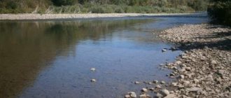
From the village of Nikolo-Perevoz, which stands on three rivers at the same time, the Kotorosl flows 126 kilometers to its confluence with the Volga. Thanks to its parents, it begins as a fairly wide (30 meters) and calm river. Obviously, the terrain and the waters of the Vex dampen the speed of the Estuary current. Along its entire length, including on the territory of Yaroslavl, the water flow is slow and forms numerous horseshoe-shaped bends. After the confluence of several tributaries, the Kotorosl River expands to 60 meters.
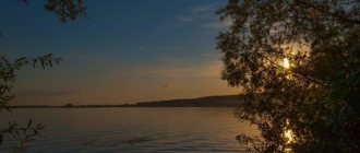
The modern river attracts fishermen, tourists and vacationers. On its banks there are boarding houses and holiday homes, and there are places for swimming in populated areas.
Kotorosl
Kotorosl
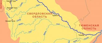
- a river in the European part of Russia, flows through the Rostov, Gavrilov-Yamsky and Yaroslavl districts and the Yaroslavl urban district of the Yaroslavl region. It is formed from the confluence of two rivers - Ustya and Vyoksa. It flows from the right into the Volga River 2623 km from the mouth (Gorky Reservoir). Length - 126 km (together with Voksa - 132 km), basin area - 6370 km². [1] The average water flow in the city of Gavrilov-Yam is 30 m³/s. The largest tributaries are Lakhost (right) and Pakhma (left). On the river are the city of Gavrilov-Yam, the urban-type settlement of Krasnye Tkachi and (at the confluence with the Volga) the city of Yaroslavl.
History of the name
Modern Kotorosl was previously called Kotorost. I wonder why? This option is considered the most popular. “Kotoratsya” in Old Russian means “to argue.” And there are plenty of reasons for the two source rivers to argue. What name should a new channel be called if its length is less than the length of one of the rivers that formed it? But the second river connects the new stream with Lake Nero, on the shore of which Rostov the Great lies. In the dispute, not only the new river was born, but also its name.
Settlements
Settlements near the river: Rostov district
— Nikolo-Perevoz, Kladovitsy, Novonikolskoye, Kurbaki, Strely, Polezhaevo, Golovinskoye, Priimkovo, Baklanovo;
Gavrilov-Yamsky district
- Tsybaki, Chernaya, Kuzovkovo, Nikulino, Purlevo, Strokovo, Koshcheevo, Romantsevo-Dubikovo,
Gavrilov-Yam
, Militino, Ostashkino, Beli, Romantsevo, Khankino, Prilesye, Unimer, Ulybino, Mezhdurechye, Vostritsevo, Stepantsevo, Smalevo , Ramenye, Spas, Gore-Gryaz, Popovka, Zamorino, Prislon, Kuzminskoye, Vedenye;
Yaroslavl district
- Lupychevo, Belkino,
Red Weavers
, Kormilitsyno, Komarovo, Ershovo, Nagotino, Kozmodemyansk, Borovaya, Rechnoy, Barge Haulers, Cherelisino, Dubki, Kozmodemyansk, Solonets, Baryshkino, Nikulskoye, Gorbunovo, Kurilovo, Plotinki, Remennitsy, Boitovo, Vorobyovo, Sabelnitsa, Prikalitki, Kostino, Osovye, Medvedkovo, Ivanovsky Perevoz, Menagerie, Pakhma, Penki;
Yaroslavl
. [6]
Kotorosl and Yaroslavl
The arrow of the Volga and Kotorosl rivers is the place where the city of Yaroslavl arose. It is believed that it was founded in 1010 by the Rostov prince Yaroslav the Wise. The new fortress was supposed to protect the water approaches to Rostov and trade routes. The log city, growing, turned into a large settlement with many temples, monasteries, trade and craft settlements.
The entire history of the existence and development of Yaroslavl is connected with the development along Kotorosl, which divides the modern city into two parts. A small section of the embankment from Strelka in the 11th century stretched to the Spassky Monastery, and then to the Church of St. Nicholas the Mokroy in the 19th century. The modern embankment ends at the Tolbukhinsky Bridge and stretches for 3 km.
Researchers claim that during pagan times, one of the temples with idols-gods was located on the site of the Spassky Monastery. The baptism of local residents took place in the waters of the Kotorosl River in this place. The tradition of carving the Jordan into the ice on the feast of the Epiphany near the monastery walls is explained precisely by this event.
The most active development of the embankment was in the 16th century, when Yaroslavl became one of the largest cities of the Moscow State. On the banks of the Kotorosl, the road from Moscow to Yaroslavl was divided into three directions: Vologda, the Middle Volga region and Ladoga region.
Prosperous residents of Yaroslavl chose these places to build beautiful and rich houses. Like many centuries ago, the Spassky Monastery with stone walls and buildings instead of wooden ones adorns the bank of the Kotorosl River. Yaroslavl is also famous for its other temples and cathedrals, many of which were built along the river. Slobodas, previously inhabited by ordinary people, have long been included in the territory of the modern city.
Where the Kotorosl and Volga rivers formed the Strelka in Yaroslavl, numerous city events are held annually, fountains operate, and beautiful flower beds are laid out.
Source
Water register data
Tributaries (km from mouth)
- 10 km: river Pakhna (Pakhma) (lv)
- 27 km: Vondel River (lv)
- 50 km: Shopsha river (lv)
- 54 km: Talitsa River (lv)
- Frying pan (pr)
- Grabbing (Lv)
- 73 km: Kobylka river (pr)
- Bochevka (pr)
- Rukhta (pr)
- 85 km: Lakhost River (Chernaya, Sorokhta) (ave)
- Turovka (BGN)
- Dubrovka (lv)
- 96 km: Black River (Vysokovskaya) (pr)
- 126 km: Ustye River (lv)
- Duct channel (pr) [1][6]
Kotorosl
Kotorosl is a river in the European part of Russia, in the Yaroslavl region; right tributary of the Volga.
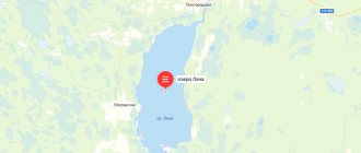
Kotorosl is formed at the confluence of the Ustye and Vyoksa rivers, flowing from Lake Nero. The length of the river is 126 km (together with Vyoksa 132 km), the basin area is 6370 km 2 - the 18th largest tributary of the Volga in terms of basin area and the 38th longest tributary of the Volga [*] The rating includes tributaries related to large and medium-sized rivers; When comparing tributaries of the main river, the lengths of their components are not taken into account. According to consolidated data from the State Water Register and the Popular Science Encyclopedia “Water of Russia”. . Kotorosl flows into the Gorky Reservoir. Main tributaries: Lakhost (right); Estuary, Vondel, Pakhna (Pakhma) (left). The hydrographic network is well developed. The density of the river network is 0.5 km/km 2. There are 823 lakes in the basin.
Main tributaries of the Kotorosl (middle rivers)
| Inflow | km from the mouth | Shore | Length (km) | Basin area (km 2 ) | Average long-term river flow (km 3 /year km from the mouth) |
| Estuary | 126 | left | 153 | 2530 | 0.285 30 |
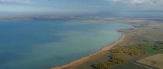
The river basin has a diamond shape. Its relief is represented by hills separated by gently sloping closed depressions, mostly swampy. In the upper reaches, the width of the channel is about 30 m, the channel is winding, and the current is weak. Before the confluence of the Lakhost tributary, the banks are treeless. In the middle reaches (below the town of Gavrilova-Yama), the river flows in a deep valley, almost without meandering. The banks are hilly. The longitudinal profile of the river bed is stepped. Below the village. The Krasnye Tkachi river goes out to the Yaroslavl-Kostroma lowland; The width of the channel increases to 60 m. To its mouth (within the city of Yaroslavl), Kotorosl forms huge horseshoe-shaped bends.
The climate in the river basin is temperate continental. The average annual air temperature is +2.6°C. The coldest month is January (average air temperature is -11ºС). During sudden cold snaps, the air temperature drops below -30°C, and in some years below -40°C. Summers are generally warm and moderately humid. The warmest month is July (average air temperature +17°C...+18°C). On some hot days, the maximum daily temperature reaches +37°C. The annual precipitation is about 650 mm. The first snow cover usually appears in the last ten days of October. About a month after this, a stable snow cover forms: its maximum value occurs in the last ten days of February - the first ten days of March. The water reserve in the snow cover reaches its maximum values in early and mid-March (90–92 mm).
The average long-term water flow near the city of Gavrilova-Yama is 30 m 3 /s (flow volume 0.947 km 3 /year). The river is fed mainly by snow. In the annual water flow, the share of spring is 67%, summer-autumn – 23%, winter – 10%. During high water (April–June), the river overflows greatly, covering areas up to a kilometer wide with water. Freeze-up on the river lasts from November to April; ice drift occurs in two days.
According to its chemical composition, water belongs to the hydrocarbonate class and the calcium group. The mineralization of river water during high water is about 100 mg/l, during the summer low water period – 350–400 mg/l. Many parts of the river are polluted. Mouth section of the river Kotorosl is under the influence of discharges from industrial enterprises. The quality of the water in the river has deteriorated and the water is now assessed as dirty. Main pollutants: total iron, copper, phenols, etc.
On the bank of the river (near the former village of Bolshoye Timerevo) there is the Timirevsky archaeological complex (9th - early 11th centuries), consisting of unfortified settlements and burial mounds. In the middle reaches of the Kotorosl and in the suburbs of Yaroslavl along the river there are many sanatoriums, holiday homes, and holiday villages. The river is popular with water tourists. In Yaroslavl, four road and two railway bridges span the river. The river basin is densely populated. It contains 71 settlements. On the river - the city of Gavrilov-Yam, the urban-type settlement of Krasnye Tkachi, at the confluence with the Volga - the city of Yaroslavl.
Source
Kotorosl River on the map
The Kotorosl River is the deepest and largest tributary of the Volga in the Yaroslavl region. The source of the river is considered to be the confluence of the Vexa and Ustye rivers, flowing from Lake Nero. The Kotorosl flows into the Volga near the Gorky Reservoir in the vicinity of the city of Yaroslavl.
The main tributaries are the Pakhma and Lakhost rivers; there are many settlements on the river, the city of Gavrilov Yam and the village of Red Weavers.
The total length of Kotorosl is 126 km. Previously, the name of the river sounded like Kotorost and most likely came from the Old Russian word “to argue.” Fishing and recreation on the Kotorosl River
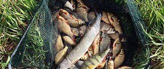
The river contains roach, bleak, crucian carp, bream, pike, silver bream, and bream bite well.
In the upper reaches of the banks of Kotorosl there are no trees, the channel up to 30 meters wide is winding, the current is quiet. In its middle course, the river carries its waters through a deep valley and is surrounded by wooded hills. Below the village of Krasnye Tkachi the channel widens to 60 meters.
On the banks of the Kotorosl there are sanatoriums, holiday villages and holiday homes. Along the high river floodplain lie picturesque pine and birch forests, famous for their abundance of mushrooms. Many come here to pick medicinal plants and berries: wild strawberries, raspberries, lingonberries, viburnum.
The coastal forests are home to many songbirds; hunters hunt wood grouse, black grouse, and hazel grouse. Wild ducks and geese nest on the water.
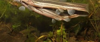
Coastal thickets provide shelter for many representatives of the animal world. In the forests there are wild boars, hares, moose, deer, foxes, and wolves. A muskrat settles near the water, and a beaver and a mink have acclimatized well.
Source
Kotorosl River
The Kotorosl River is the largest and most abundant tributary of the Volga within the Yaroslavl region. The real source of the Kotorosl River should be considered the Ustye River, however, according to tradition associated with the history of the development of the territory, its beginning is considered to be the confluence of the Ustye and Veksa rivers (flowing from Lake Nero). It flows into the Volga within the city of Yaroslavl.
In the upper reaches, the Kotorosl crosses the open treeless surface of the northeastern part of the Rostov basin, in the middle reaches it cuts through the hilly terrain with a narrow and rather deep valley, after which it flows within the wide Yaroslavl-Kostroma lowland, often changing direction and forming huge horseshoe-shaped bends. The length of the river is 132 km with a drainage area of 6370 sq. km. The width of the channel ranges from 25 to 60 m, the depth from 1.5 m or more. The average river flow in the Gavrilov-Yama area is 6.0 m3/sec. The name of the river, which sounds like “Kotorostl” or “Kotorost” on old maps, is apparently of Finno-Ugric origin.
At the mouth of the Kotorosl River within the city in the 18th – 19th centuries there were numerous unloading piers and warehouses of Yaroslavl. The river itself was navigable to Lake Nero (however, navigation even in those days encountered difficulties - partly due to the improper construction of dams and dams of numerous factories driven by the river). At two factories, Yakovlevskaya and Gagarinskaya, even channels were built to bypass the dams along the Kotorosl. During high water, tikhvinkas were rafted down the Kotorosl, and during low water, boats loaded with flour from mills located on the Ustye River.
Nowadays the river is navigable only along the lower 10 km of its course. The Kotorosl floods were always very significant; in the spring, in certain sections of the valley, water flooded an area up to a kilometer wide or more: the flood meadows formed in this way yielded up to 200 pounds of hay per tithe. Nowadays, as a result of the incision of the Kotorosl channel, many sections of its former floodplains have emerged from the flood level, are overgrown with forests, plowed up or occupied for construction.
From Gavrilov-Yam to Krasnye Tkachi the river flows within a wide, deeply terraced valley. One of the oldest recreational and tourist areas in the suburbs of Yaroslavl is closely connected with the river. Along Kotorosl there are many holiday villages, gardening associations, children's camps, holiday homes and tourist centers. Along the high floodplains and terraces of Kotorosl, picturesque pine and pine-birch forests have been preserved in places. Near the river there are resting places for Yaroslavl residents (the “River” platform, etc.).
The longitudinal profile of the Kotorosl River has not been developed to this day, so the channel is characterized by a fast flow, a trough-shaped bottom profile and an abundance of rocky rifts. The river is suitable for tourist rafting during the entire open channel period, and in high water – for sports rafting. The riffle near Borovoye is a traditional training place for water tourists.
Of the tributaries of the Kotorosl River, the most significant are Pakhna (length 48 km), Lakhost (87 km), Sara and Ustye.
Source