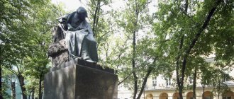
Classics of the genre: Lake Ladoga
Lake
Ladoga Ladoga is a symbol of the Leningrad region, the largest fishing and navigable lake, approaching the sea in size, with a total area of 18.5 thousand square meters. km. Pleasure boats travel along Ladoga, diverging along different tourist routes: to the island of Valaam (and from there to Kizhi and Mandrogi), to Finland and further to Tallinn and Stockholm. When choosing a river excursion, you will certainly pass through Ladoga, leaving behind the wooded banks, rocky cliffs and a huge expanse of water. From the island of Kanevets to the island of Valaam, small boats of pilgrimage tours run, and huge multi-deck ships lazily sail by with merry tourists. Choose whatever your heart desires. If you are short on time, the Meteor pleasure boat will take you to Shlisselburg and Kronstadt. Of course, now you can get there by car, but a river walk will give the traveler special pleasure. During my childhood, this was a separate adventure, in addition to the historical sites and museums in the fortresses and forts of the northern sea city. History buffs of the 20th century will remember that Lenin fled from Razliv to Finland on the ice of Lake Ladoga, the White Guard rebellion was sunk and executed there near Kronstadt, and, of course, for Leningraders Ladoga is, first of all, the Road of Life.
If you are tired of historical events, Ladoga is a place for tourist boat trips. Kayak and kayak trips are carried out here, you can practice on the rapids and walk along the Karelian shores all the way to Petrozavodsk.
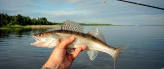
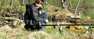
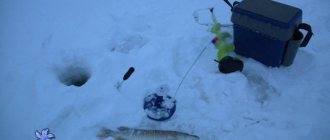
In the spring, on Ladoga they catch the most typical fish from St. Petersburg - smelt, which we highly recommend trying fried or pickled for guests who want to get a taste of the city. In general, fishing on Ladoga is available almost all year round, excluding spawning periods. Spend time as you like: with a paddle, fishing rod or camera.
General characteristics of the region's hydrology
The hydrological network of the Leningrad region, together with small rivers and streams, includes 25 thousand water arteries. There are two watersheds in the region, the Baltic and Ladoga. The Volkhov, Vuoksa, and Svir flow into Lake Ladoga. The Neva stands apart, flowing through the lowlands between watersheds and connecting Ladoga with the Gulf of Finland.
Map of the Leningrad region with rivers and lakes
Plain type rivers are characterized by snow-rain water supply and rain floods. The climate of the region is characterized by winter freezing of rivers with April ice drift. Rivers originating at the heights of the Karelian Isthmus abound in rapids and riffles.
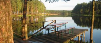
Swimming on weekdays: Korkin Lakes
Korkinsky lakes
A chain of lakes under the general name Korkinsky, located in the Vsevolozhsk region. St. Petersburg residents get to them by car along the Murmansk highway to Razmetelevo or by minibuses (No. 579, 511, 469, 565 from the Ulitsa Dybenko metro station), when the hot weather beckons for a swim, and tomorrow a full day of work awaits.
There are no historical sites or excursion routes around the dacha, dacha, dacha. And a forest where birds sing and mushrooms or berries grow (the year can be “berry” or “mushroom” in terms of yield). The beach is sandy, but not very clean, wear shoes, including for swimming. There are a lot of people, you won’t get lost or get lost, there is always the opportunity to go out to smell the aroma of barbecue. There is an entry fee, but it’s not far from the barrier on foot.
Not far from St. Petersburg: Kavgolovskoye and Lembolovskoye lakes
Kavgolovo and Lembolovo are all places in the same Vsevolozhsk region, loved by tourists and athletes. The Karelian Isthmus - for a local, these words contain all the charm of northern nature, the singing of nightingales, clean water, pine trees, surprisingly “tasty” air and the sunny weather so valued by St. Petersburg residents. The best dachas, sanatoriums, holiday homes and pioneer camps have always been located there.
Kavgolovskoe
Lake Kavgolovo
Kavgolovo is especially popular in winter; there are campsites, sports and tourist centers, and most importantly: wonderful trails for cross-country and alpine skiing. In summer the lake beckons here. Lake Kavgolovskoe is shallow (maximum 4 meters), clean and quite warm. It's so nice to camp here! And in the south, closer to Toksovo, a site of a primitive man with petroglyphs was found.
You can get there by train from the Finlyandsky station to the station. Kavgolovo.
Lembolovskoe
Lembolovskoe Lake
Lembolovskoe or the devil’s lake (in the languages of the Finno-Ugric group “lemboi” is the devil, I remember how my grandmother said in her hearts: “Ay, lemboi took him!”). A very beautiful, shallow and warm lake, which is part of the general basin of the Ladoga Lakes. The Karelian Isthmus, surrounded by sanatoriums, sports and children's camps, wonderful coniferous and mixed forest. The lake goes around the Bear Peninsula, several small rivers and the border river Viissi-iokki (aka Lembolovka) flow into it. Anyone who gets tired of nature and silence (although the forest is alive and there are a lot of people) can visit the wooden church in Vaskelovo or the Lutheran church in the village of Lembolovo.
It is convenient to get there from the same Finlyandsky station to the station. Lembolovo.
Big Simaginskoye Lake
Big Simaginskoye Lake
Big Simaginskoye Lake is located near Zelenogorsk, in the Ilyinsky district (Vyborg district).
Clear water, sandy beach, pine trees - the landscape is really beautiful, but the water is cool even in the heat. However, Beauty is not suitable for lovers of extreme temperatures, which means swimming is quite possible, except perhaps with small children. The lake is fed by springs, which is why the water in it is clean and cold, pine and spruce trees are reflected in it at full height. You won’t see beaches with barbecues there, entry and entry are free, in general, nature has not been ennobled and, accordingly, has not been spoiled by the labors of human hands. St. Petersburg residents love Simaginsky lakes and come on weekends, usually by car. The lake is large, there is usually enough space. You can walk from the Zelenogorsk railway station; literally everyone you meet will show you the way.
Where to relax with tents in the Leningrad region? Best Camping Spots
Unique nature, absence of people and unusual recreation - these needs can be easily satisfied by camping. This type of travel is considered extremely budget-friendly, since to implement the idea you only need a tent (and not always), a supply of food and the desire to merge with the outside world.
There are a huge number of places for quality camping near St. Petersburg. You can get to the desired locations by car, train or boat.
As you may have guessed, this review will be devoted to the best destinations in the Leningrad region for a holiday with tents. Clean lakes, fresh air, forests and a sense of freedom are guaranteed!
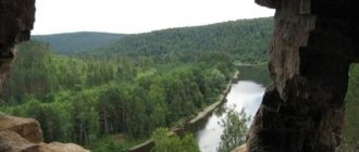
Lakes of Podporozhye district
It is really far, and it is reasonable to choose a trip along the Vepsian Upland if you have at least a week of free time. Take a tent, backpacks, load a boat in the trunk - you are heading to the land of untouched nature, dense forests and non-working mobile phones. There are much more lakes here than Google and Wikipedia know.
Route: from Ladozhsky station by train to Svir station, then by bus to Podporozhye. Regular bus No. 801 from the Northern bus station to the village of Vinnitsa, regular bus No. 964 and 895 from bus station No. 2 on the Obvodny Canal - to Podporozhye. By car - along the Murmansk highway to Lodeynoye Pole, then turn towards Podporozhye. There are several directions from Podporozhye; we suggest heading towards Vinnytsia.
The road is winding, but still paved. On the way to Vinnytsia, almost along the road, you will come across several forest lakes. In each, the water is so pure that you can drink it fresh by scooping it with your hand directly from the lake. Fish (fishing is everywhere) should be properly cooked in the same water where it was caught, adding onion, bay leaf and salt. It is better to swim close to the shore, the lakes have cold springs, their depth is from 10 to 70 meters, be careful.
Syargozero
Syargozero
Turn right, a little before reaching Zayatskaya, along the forest road for about a kilometer. A deep dark lake in a coniferous forest; not only water lilies, but also white lilies grow near the shore. Fish lake, trout nursery nearby. Swim with caution; the lake has muddy shores, except for a few sandy pools. During the Great Patriotic War, the front line passed here, and to this day “black trackers” with metal detectors collect objects from the long-past war.
Kara Lake
Kara Lake
Turn left to Zayatskaya (in Vepsian the village is called Kara), on the shore of which there is a large village. The lake is beautiful, fishy, perfect for those who are afraid of getting lost.
After driving a few more meters before the turn to Ignatovskoye, go deeper into the grove, past a field and a clearing, you will see something unusual for these places.
Large rivers in the western part of the region
In terms of river fauna and flora, drainage, the slow lowland rivers of the west of the region differ from the northern ones. The settlement of the region's indigenous inhabitants began earlier along the rivers of the west. Narva and Izhora were the trade routes of the Russians. The full flow of the rivers made it possible to build the first sawmills and flour mills on them. Let us consider these differences and their impact on the settlement of residents in detail.
Narva
The deep-flowing Narva, flowing from Lake Peipus near the village of Skami, became the border watershed of the Russian-Estonian border. The border crossing runs along bridges across the river between Estonian Narva and Russian Ivangorod at the confluence with the Gulf of Finland (Narva Bay). With a length of 77 km, the Narva river basin area exceeds 56,000 square kilometers. Sharp changes in relief formed the Omut rapids and Narva waterfalls on the river. The bottom is located at a depth of 3-4 meters, deepening to 15 meters before the mouth. The ice on Narva lasts for up to five and a half months, ending with an impressive ice drift. Narva's water supply is provided by Lake Peipus, the Rosson, Chernaya, and Plyussa rivers. The Narva Hydroelectric Power Station was built in the middle reaches. Below the dam and in the reservoir of the hydroelectric power station, Narva is navigable for 30 kilometers. In the creeks and riffles of Narva, fishermen fish for roach, bream, rudd, perch, and pike. Occasionally, lucky fishermen come across the delicious Narva lamprey. The main historical monument on the banks of Narva was the Ivangorod Fortress.
Ivangorod fortress in the lower reaches of Narva
In the 15th-17th centuries, the Ivangorod fortress was repeatedly the site of battles between Russians and Poles, Germans, and Swedes. After the capture of the fortress (1704) and victory in the Northern War, the strategic importance of the fortification decreased. In addition to the fortress, tourists can see in Ivangorod a museum in the Red House (royal customs house), and an art gallery in the Panteleev mansion.
Izhora
With a length of 76 kilometers, Izhora begins from the springs of the Izhora Upland (Gatchina district, Skvoritsy village). Along the Prinevskaya lowland, Izhora, before flowing into the Baltic, crosses the Tosnensky and Kolpinsky districts. In the upper reaches of the fast river there are rapids and riffles, which give way to deep holes and quiet pools. When entering the plain, the depth of the Izhora increases (in the middle reaches - up to 2 meters). At the mouth, the river widens to 60 meters and deepens to 4 meters.
View of the lower reaches of Izhora from the Admiralteysky Bridge
The river and several of its tributaries received their name from the indigenous people who lived in this area. After the battle at the mouth of Izhora, Prince Alexander Yaroslavich received his nickname “Nevsky”. THIS IS INTERESTING. Over the course of several centuries, the Izhorians were completely assimilated into Russia. Nowadays, just over 300 people speak their native language (of the Finno-Ugric group) and record the “Izhora” nationality in their passports. Civilization has most affected the mouth of Izhora, where a dam with a dam and bypass canals were built. But flour mills and sawmills have been built on the lowland river since the 17th century. Of the 200 tributaries of the Izhora, the following rivers stand out in size:
- Vinokurka (25 kilometers);
- Chernaya (23 kilometers);
- Parisa (13 kilometers);
- three Izhorkas (Popova, Bolshaya, Malaya).
In the last century, Izhora was considered a trout river; large specimens of river trout were caught in the pits. Nowadays, catching trout is becoming a major fishing success.
Thanks to transport accessibility, fishing in Izhora is popular among St. Petersburg residents. The best places for fishing are:
- area of the village of Romanovka (trout can be caught on the rifts and in deep holes);
- a section of water area from Kobralovo station to the village of Lukashi (chosen by fly fishing enthusiasts);
- area of Antropshino station (perch, roach, rudd take a float rod);
- river tributaries (in which spinners catch perch and pike);
- Kolpinsky pond (used for fishing from boats, winter ice fishing for pike with girders).
Meadows
Flowing from the Tesovsky swamps of the Novgorod region, the Luga flows 353 kilometers through two northwestern regions (Novgorod, Leningrad) before flowing into the Luga Bay (water area of the Gulf of Finland, Baltic). The northern river is characterized by a sandy channel (with rocky areas), intermittent floodplain, oxbow lakes and shoreline bays. Among the large tributaries of the Volosovsky region, we can note the Khrevitsa, Peleda, Solka, Notika.
Autumn Meadows in the middle reaches
Luga is practically not used for hydropower and shipping. Cities on the river banks include Kingisepp (45,000 inhabitants), Luga (35,000 inhabitants). More than 20 bridges were built across the river, including multi-track railway crossings. In addition to fishing, which is not prohibited throughout the entire water area, kayaking trips are popular in Luga. Water tourists from St. Petersburg begin rafting at the bridge on the northern outskirts of Luga. On the kayak route, interesting places are Posolsky Island, forest glades behind the villages of Tolmachevo, Partizanskoye, and the mouths of the Kaskolovka and Mertvitsa rivers.
Gonginskoye Lake
Gonginskoe Lake
A large sandbank, well-warmed up light water, attracts those who want to find a beach holiday in the North of the Leningrad Region. A little further from the sand spit, the lake takes on its usual forest appearance, with fire pits and berry patches surrounded by ancient trees. A little further on the shore of the lake is the village of Velikiy Dvor (Gonginichi). It is known for the legend of a visit by aliens (information about this can be found on almost any Russian-language ufological site) and the abstract five-meter art object “Kavarga” made of metal structures and concrete (sculptor Dmitry Kavarga).
On the way to Vinnytsia, the largest commercial lake is.
Tumazy
Tumazy
There is a most picturesque village on its shore. It is believed that its residents can cast a fishing rod directly from their windows. The water is completely clear, which does not interfere with excellent fishing. There are areas of shallow water where you can swim in warm water, but the locals sail on boats further to the forest, where they sit with fishing rods and set nets. Tumazy is a favorite vacation spot for local residents, but you will always find a place for a car and a secluded area where no one will disturb you.
The forests around are full of mushrooms, blueberries, blueberries, lingonberries, large raspberries grow in the clearings and along the roads.
From Vinnitsa you can turn right to the Vepsian villages of Nemzha, Ladva, Kurba and further - far into the forest, to the most amazing distant lakes. Along the way you will meet the White and Black lakes. Small reservoirs are a couple of kilometers apart in a straight line, but in Cherny there is dark, mirror-like water and a muddy bottom, with wonderful berry fields all around. The White Lake is filled with light transparent water, which is considered holy after the Chapel holiday. On a July day, an ancient icon is carried from Nemzha in a religious procession, lowered into the water, and then all the participants of the holiday pass under the images. The water is considered holy, and people swim regardless of weather conditions. For true lovers of protected trails, a forest road to ancient forest lakes begins 10 km from the village: Danilkino, Mertvoe, Palmozero. This is where you can be alone with nature. In the Podporozhye region there are practically no industries; the environmental situation is practically the same as it was hundreds of years ago.
If you turn left from Nemzha, you can see the village of Ozera, standing on the lake of the same name, and then, along the bed of the Oyat River, you get to the cinematically famous village of Shondovichi, where the film “Once upon a time” was filmed with Fyodor Dobronravov, Roman Madyanov and Irina Rozanova in the main roles roles.
The Podporozhye region is rich in lakes and forests that await true lovers of travel to the edge of the Leningrad land.
Large rivers of the northwest
Among the rivers with sources on the Karelian Isthmus in Lake Ladoga, the following stand out:
- Neva;
- Vuoksa;
- Tarkhanovka:
- Earring;
- Seleznevka;
- Hello;
- Sandy;
- Gladysh.
Let's look at some of them in more detail.
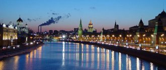
Neva and St. Petersburg
The deep-flowing Neva, with St. Petersburg standing on it, is known to every Russian. The river became an important city-forming factor even when Peter the Great founded the “northern capital”. The city was originally built on both banks of the Neva; the builders immediately encountered such river features as swampy banks, unstable soils in the coastal zone, and seasonal floods (with unpredictable levels of water rise). With a short length (74 kilometers) in terms of drainage volume (2500 cubic meters per second), the Neva is ahead of most European rivers, second only to the Northern Dvina, Kama, Pechora, Danube, and Volga.
Water transport
In addition to supplying water to the metropolis, the Neva allowed St. Petersburg to become an important transport hub. The depth of the fairway allows maritime navigation. Therefore, the port of St. Petersburg is considered not a river port, but a sea port, occupying first place in the country in transshipment of container and general cargo. In St. Petersburg, more than 300 bridges (of which 21 are drawbridges) were built across tributaries of small rivers, canals, and island channels.
Evening view of the raised Palace Bridge in St. Petersburg
We invite you to watch a fascinating video about the Neva:
Architecture and landscaping
During the development of the city, the banks of the Neva and Vasilyevsky Island were chosen for the construction of palaces of the Tsar and the nobility, main public buildings, cathedrals, naval and army headquarters. Famous European architects - Jean Baptiste Leblond, Schlüter, Domenico Trezzini, Rastrelli (Bartolomeo Carlo and Bartolomeo Francesco) worked on the architecture of such buildings as the Admiralty, the Winter Palace, the Peter and Paul Fortress, the ensembles of the Palace Embankment, the Spit of Vasilyevsky Island.
Collection of architectural monuments on the Palace Embankment of the northern capital
The city blocks of the metropolis occupy tens of kilometers on both banks of the Neva. But most of the city’s parks and gardens are located on the banks of the Neva, from which the following gardens can be distinguished:
- Alexander Nevsky Lavra;
- Spartacus;
- Malokhtinsky Square;
- Kurakina's dacha;
- Cathedral of the Smolny Monastery;
- Tauride;
- Smolny Institute;
- Alexandrovsky;
- Rumyantsevsky;
- Summer.
THIS IS INTERESTING. St. Petersburg is the undisputed leader among Russian cities in terms of river street names. Only in the city on the Neva, in addition to Nevsky Prospect, are there the embankments of Pryazhka, Moika, Kryukov Canal, Fontanka, Griboyedov Canal, Karpovka River, and Chernaya Rechka.
Vuoksa: hydropower and recreation areas
Vuoksa, flowing from the Finnish Lake Saimaa, flows 143 kilometers across Russia, flowing into the lake of the same name. From it the spillway passes into Lake Ladoga through several branches, the Tikhaya and Burnaya rivers.
The rapid current of the Vuoksa on a rocky area
The large elevation difference in the upper reaches of the Russian section of Vuoksa allowed the construction of two hydroelectric power stations: Lesogorsk and Svetogorsk. The cities of Svetogorsk and Kamennogorsk were built on the river and lake banks. Priozersk In the 11th-13th centuries, the route along the western channel of the Vuoksa (from the Gulf of Finland to Ladoga) was a busy trade route. After the western channel dried up (it became a chain of lakes), this path was abandoned. The shores of Vuoksa and the lake are popular among St. Petersburg residents as a vacation spot; cottage villages, campsites, and recreation centers are being built here. Fishermen, in addition to the usual rudd, roach, and pike, can catch whitefish or salmon in Vuoksa.
Earring: typical northern river
Under the name "Urpalanjoki" the northern river Serga flows 90 kilometers through Finland. Starting in Lake Suri-Urpalo on the territory of our western neighbor, the Serga flows for the last 10 kilometers through the Vyborg region, flowing into the Chistopol Bay.
River Serga in the forests of the upper reaches
At the mouth of the river there is good fishing for roach, perch, pike, and redfish. If you have good fishing luck, you can catch burbot and grayling. But in order to travel to the border areas of the Vyborg and Kingisepp districts, you need to issue a pass to the border zone. The authorities plan to carry out this formal procedure over the Internet.
THIS IS INTERESTING. On border rivers, ITS (wire fences) are installed one and a half kilometers from the actual border. You can't go behind them. Downstream of the ITS you can fish and swim. At night, it is better not to approach the river banks near the border (even with a pass) so as not to provoke the border guards.