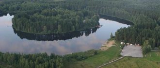
Vishera River
One of the most picturesque rivers of the Urals originates on the territory of the Vishera Nature Reserve, in the west of the Ural Mountains. Its length is 415 km. In the upper reaches there is a river with a fast current and a large number of riffles, flowing surrounded by mountain ranges.
Yuryuzan River
Reservoirs of the Kunashak fish factory
The lakes are characterized by shallow depths and a low species composition of fish. Large quantities of crucian carp.
Oz. Kunashak. Located near the regional center. Area 235 hectares, depth about 4 m. The bottom is muddy. Aquatic vegetation is large. There is crucian carp. The productivity of the reservoir is 51.9 kg per hectare. The planted carp did not take root.
May 10, 2021
Revun Threshold and Smolinskaya Cave
Oz. Big Kuyash . Located on the Sverdlovsk-Chelyabinsk highway near the village of Bolshoi Kuyash (on the eastern side). The banks are flat. Reed thickets are insignificant. Area 1,242 hectares. The average depth is 2 m, the greatest is about 6 m, transparency is 2.5 m. Roach, perch, and ruffe are found. Productivity 35.7 kg.
Oz. Kainkul. It is located near the village of Sary (on the Sverdlovsk-Chelyabinsk highway). Area 520 hectares. The greatest depth is 3 m. Fish: crucian carp, roach, carp, ripus. Productivity 22.1 kg per hectare. Every year, juvenile carp and hybrid larvae are planted for rearing.
Oz. Karagaikul. Located near Lake Kainkul, to the west. Area 1203 hectares. The greatest depth is 5 m. The nearest village is Ibragimovo. Fish: roach, perch and cheese (peled). Fishing for cheese is currently prohibited.
Oz. Kaldy. Located near the village of Sary. The water is brackish. Area 1,670 hectares. The greatest depth is 7 m. Transparency is 3 m. There are reeds in places along the banks. There are roach, perch, tench, ruffe and pike. Productivity 35.9 kg.
Oz. Chebakul. East of the Sverdlovsk-Chelyabinsk highway. The water is brackish. There is a small rocky island in the middle of the lake. In places along the banks there are reeds. There are especially many of them in the southern part of the reservoir. Area 1,850 hectares. The greatest depth is 5.5 m. There are roach and pike. Rhipus planted twice. Roach can be caught well with a fishing rod. The weight of the fish reaches 1 kg. In the western part of the reservoir (towards the village of Sary) there is a channel. Behind it is Lake Maly Chebakul. There is crucian carp there. From Big Chebakul, a huge mass of roach goes through the channel to spawn in Small Chebakul. From this small reservoir, young roach go to Bolshoy Chebakul for the winter. The very overgrown, small, stale Small Chebakul is suitable only for the wintering of such unpretentious fish as crucian carp. The productivity of the lake is 48.6 kg per hectare. In such large reservoirs of the fish factory as Uelgi, Abatkul, Seigarly, Shugonyak, Ala-kul, Surtanysh, Karakli-Mayan, Mayan, Kun-gul, Aydykul and others, only crucian carp is found. There is especially a lot of it in the lake. Aydykul, whose area is 2,652 hectares and productivity is 64.9 kg. During the summer season, more than 1,700 quintals of crucian carp are taken from the reservoir.
September 6, 2021
Talk stone. Saturday walk
Yuryuzan River
The total length of the Yuryuzan River is 285 kilometers. The large cities of the Chelyabinsk region are located on the river: Yuryuzan, Trekhgorny, Ust-Katav. There are no large settlements in the river area on the territory of Bashkiria. On the river, in the Salavat region of Bashkortostan, there is the Yangan-Tau resort, which is famous for its Kurgazak mineral water source.
Reservoirs of the Chelyabinsk fish factory
Oz. Sugoyak. Located in the Krasnoarmeysky district, not far from Chelyabinsk. The area occupied by the lake is 1000 hectares, the greatest depth is about 8 m. The bottom is sandy and muddy, with reeds along the banks. Keys available. Fish: roach, perch, carp, whitefish, crucian carp and ripus. Acclimate the bream. The settlements of Kharino and Pashnino are located on the shore. The Chelyabinsk Tractor Plant has equipped a permanent base for amateur fishermen.
Oz. Ogachkul. (Sosnovsky district). Located on the Chelyabinsk-Sverdlovsk highway. The village of Sultaevo is located on the shore. The area of the lake is 600 hectares, the greatest depth reaches 5 m. The bottom is sandy, muddy, partially overgrown with reeds. Fish: carp, roach, crucian carp, rhipus planted. To prevent starvation and death of fish on the lake in winter, a wind-powered aerator of the Reshetnikov system operates. There is a permanent fishing base on the lake.
Oz. Round. Located in the Etkul district near the village of Shelomentsevo. Area 70 hectares, depth more than 3 m. The bottom is sandy and muddy. Inhabitant of crucian carp, common carp and hybrid ripus. Along the banks there is a birch forest.
Oz. Shelomentsevo . Located in the Etkul district near the village of Shelomentsevo. Area 142 hectares, depth 4.5 m. Crucian carp, carp, hybrid whitefish with ripus are found. The annual catch of the hybrid is 10−17 c. There is a forest along the banks.
Oz. Dengino. Located in Oktyabrsky district. On the shore is the village of Dengino. The area of the lake is 547 hectares, depth is up to 8 m. The bottom is muddy, sometimes sandy. There are reed thickets. Fish: crucian carp, carp, hybrid ripus. Carp catches per year reach 500 c. Other lakes are stocked with juvenile carp. Periodically, the lake is subject to destructive frosts.
September 14, 2012
Abandoned quarry "Old Lens"
Uvel reservoir. Located on the Uvelka River in the Uvelsky district. In the southern part of the reservoir is the city of Yuzhno-Uralsk, on the northeastern shore is the village of Kichigino. The area of the reservoir is 1700 hectares, the greatest depth is up to 11 meters. There are roach, perch, pike, bream and some other species of fish. In 1965, pike perch larvae and spawners were stocked. Bream has taken root especially well here, planting it from 1954 to 1960. Tens and hundreds of thousands of juvenile bream are caught here for breeding in other reservoirs. The reservoir becomes a very valuable nursery for bream.
Shershnevskoye Reservoir. Located on the Miass River, west of Chelyabinsk, near a pine forest. The surface area of the reservoir is 3900 hectares, the average depth is 4.5 m, the greatest depth (at the dam) is 11 meters. Local fish are found: roach, perch, pike, burbot, tench, ide, crucian carp, gudgeon. Since 1964, bream has been stocked from the Uvel Reservoir. The Shershnevskoye Reservoir is becoming a favorite and accessible vacation spot for anglers. In June 1967, pike perch were acclimatized.
Lake First. It is located in the eastern part of Chelyabinsk, within its urban lands. The mirror area of the lake is 1,870 hectares, the greatest depth is 12 meters. Previously, wastewater from city enterprises was discharged here and no fish were found. But in 1956, the pollution of the reservoir stopped and the fish factory began stocking it with fish. Since 1957, whitefish, carp, and whitefish have been brought here several times. Now in Lake First there are whitefish, peled, ripus and its hybrids, carp, bream, roach, crucian carp, and perch.
Lozva River
It originates on the eastern slope of the Poyasovy Kamen ridge in the Northern Urals. Flows to the southeast among the swamps of the West Siberian Plain. The river has a typically mountainous character with rifts alternating with reaches and pits. The diet is mixed, with a predominance of snow. The average water flow is 187 km. from the mouth about 70 m/sec. It freezes in October - early November, opens in late April - early May.
Reservoirs of the Kasli fish factory
Related articles
July 9, 2014
Beaches of Lake Tavatuy. Summer 2016
The reservoirs of the Kasli fish factory are located in the north of the region. The most interesting here is the chain of flowing lakes: Silach, Sungul, Kirety, B. Kasli, Irtyash. The B. Vyazovka River flows into Lake Silach from the western side. In the west, the reservoir is connected by a channel to Lake Sungul. From here there is a strait into Lake Kirety, and from it into Lake B. Kasli. The city of Kasli is located here, which is called the “city of fish and lakes.” The total length of this reservoir system. Exceeds 20 km. From Lake B. Kasli the flow passes through the city into Lake Irtyash.
Oz. Strongman. It occupies an area of 1860 hectares. The greatest depth is 4 meters, water transparency is up to 3 m. The thickness of the ice in winter reaches 90 cm, the bottom is muddy, in places there is sand, rocky ledges. Along the banks there are forests, low-lying and rocky areas. The reservoir is located several kilometers east of the city of Vishnegorsk. Productivity (average commercial fish catch per year per hectare of lake area) is very low - 8.7 kg. The lake is home to roach, perch, crucian carp, tench, ide, pike, ruffe, burbot, and ripus.
Oz. Sungul. Area 1166 hectares. The greatest depth is about 8 m, transparency is 6.5 m, ice thickness in winter is 87 cm. The banks are steep, often steep, rocky, covered with pine and other forest species. The bottom is muddy and dense in places. There is an island. On the western shore there is the Sungul carp nursery, owned by the fish trust. Behind the nursery are the picturesque Cherry Mountains. The western bank is occupied by outlying houses and dachas of Vishnegorsk. The productivity of the lake is 11.6 kg. Here you can find roach, perch, crucian carp, and occasionally carp, tench, ide, pike, burbot, whitefish, ripus, and dace.
Oz. Kirets. Area 738 hectares (according to other sources 802 hectares). The greatest depth is 5 m, transparency is 2 m. The ice thickness in winter reaches 90 cm. The bottom is more silted than in Sungul. The banks are sloping, wooded and rocky in places. The fish species are the same as in Lake Sungul, but there are ruffe and no carp. The Kiretinsky Bridge is thrown across the channel into Lake B. Kasli.
Oz. B. Kasli. Length 5.8 km, width 4.26 km, area 1896 hectares. The greatest depth is 7 m, transparency is 5 m. Ice thickness in winter is 112 cm. The banks are sloping, with rocky headlands in places. The bottom is muddy, sometimes dense, and there are chars. There is an island. The forests are almost empty. The types of fish are the same as in Suigul, however, there are a lot of ruff and no dwarf at all. Productivity 13.6 kg. On the southern shore there are industrial buildings and a fish factory office. In the bays, at the bottom, elodea grew.
June 24, 2021
Weekend on Lake Baltym. Summer 2016
Oz. Irtyash. The area occupied by this lake is 6180 hectares. The greatest depth is 12 m, water transparency is 4 m. Ice thickness in winter is 85 cm. There are islands, many crayfish. The bottom is muddy, and sandy in places. Fish caught: roach, perch, crucian carp, tench, ide, pike, ruffe, burbot, whitefish, dace, and lake pike perch. Productivity 30.3 kg. There are many juvenile bream in the catches. The Kasli fish factory owns only the northern part of the lake (up to the island), and the southern half of the reservoir is assigned to the Kyshtym fish factory. Other significant lakes containing fish species other than crucian carp are located to the west, north and east of the city of Kasli. These lakes include:
Oz. Arakul. Located northwest of the city of Kasli and east of the Silach crossing of the Sverdlovsk-Chelyabinsk railway line. The area of the lake is 340 hectares (according to other sources, 300 hectares). The average depth is 3 m, the greatest is 11 m. Transparency is 6.4 m. The bottom is muddy, compacted in places, sand and stone are found on the ridge near the island and along the rocky shores. There are reed thickets along the western shore, as well as in Olkhovskaya, Kaganskaya and Maksimova Kurye (bay). Underwater vegetation (pondweed, elodea) is significant in places and reaches a depth of 5 m. The lake is home to ruffe, tench, yellow crucian carp, bream, burbot, and whitefish. The main fish are roach, perch, and pike. Average (over four years) productivity is 38.5 kg. In the silty sediments of the deep part of the lake, even in summer, hydrogen sulfide is formed and a large 9 g of oxygen is noted, and sharp temperature jumps are observed in different and surface layers of water. These circumstances cause the death (death) of fish such as whitefish, burbot, and large bream. The death of these fish is also observed in the summer. The banks are sloping, steep and rocky in places. There are forests and mountains all around. The Kaganka and Olkhovka rivers flow into the lake. The source is the Arakulka River, on which the Arakul fish breeding plant of the fish trust is located, growing whitefish, ripus, and peled. The Arakulka flows into the Vyazovka River, and the latter into Lake Silach. In Arakulka and Vyazovka, brook trout, bred here by fish farmer I.V. Kuchin back in 1913, was recently encountered. On the northern bank of the Arakul there is a rest house, pioneer camps and a village. In the summer, people come here for fishing from Chelyabinsk, Ufaley, Vishnegorsk. Fishing is carried out mainly with a fishing rod (roach and perch), as well as with a line and spinning rod (pike).
August 19, 2014
Walk on a river bus. Traveling around Iset
Oz. Itkul. Located in the northwestern part of the Caspian region. You can get to the lake by bus from the village of Tyubuk (Sverdlovsk-Chelyabinsk highway) through the village of Voskresenskoye to the village of Vozdvizhenka, located on the shore of Lake Sinara, and from here along the forest road to the village of Itkul. The area occupied by Lake Itkul is 3048 hectares. Its length is 8 km, width 6 km. The average depth is 2 m, the greatest is 10 m. Transparency is 4 m. The bottom is muddy and sandy. There are few reed thickets, but underwater vegetation (especially elodea) is abundant. The lake is surrounded by wooded hills, and in some places there are rocky headlands near the water. The famous “Shaitan Stone” protrudes on the southwestern shore. 8 springs flow into the lake. Its only source flows into Lake Sinara. Lake Itkul is rich in fish such as roach, perch, bream, pike, dace, ide, tench, ruffe, yellow crucian carp, burbot, bleak. Whitefish and ripus are rare in catches. Itkul is especially rich in bream reserves. The commercial catch of bream here reaches up to 500 centners per year; the reservoir is considered the main bream base of the region.
Oz. Okuncul. It is located north of the village of Vozdvizhenka. Area 677 hectares. The average depth is 2 m, the greatest is about 4 m, transparency is about 4 m. Two springs flow into the lake. Flow into Lake Sinara. There are fish: roach, perch, crucian carp, tench, ide, pike, ruff, palim, dace.
Oz. Big Kuyash. It occupies a site in the north of the Caspian region, near the village of Bagaryak. The area of the lake is 21.1 square kilometers, the depth of the reservoir reaches 12 meters. On the shore of the lake there are: the village of Bolshoy Kuyash, the village of Maly Kuyash, the village of Golubinka. The bottom is very silty. There are fish: crucian carp, carp, tench. The lake is being frozen.
July 19, 2006
Reservoirs in the vicinity of Yekaterinburg
Oz. Bol. Allaki. Located near the Kasli-Tubuk tract. Area 900 hectares (according to other sources, 543 hectares). Depth up to 5 m. The bottom is muddy and sandy. The fish found here are: roach, perch, bream, carp, ide, pike, ruff, whitefish and ripus. The commercial catch of bream reaches 11 c. There is good growth of perch. Oz. Bol. Allah Oz. Alabuga. Located east of the city of Kasli. Area 812 hectares (according to other sources, 587 hectares). The average depth is 2.5 m, the greatest is about 5 m, length 4.4 km, width 2.9 km. The bottom is muddy, sometimes compacted with sand. There are perch, roach, crucian carp, tench, pike, ruff, dace, and ide. Roach is the main fish of the lake. Her growth is good. The village of Alabuga is located on the southern shore of the lake. Oz. Bol. Allaki
Oz. Big Kisegach. This lake, located north of Bolshie Kasli Lake and connected to it by a channel, is a favorite place for Kasli fishermen. Its area is 374 hectares. The greatest depth is 4 m, transparency is 2.7 m. The bottom is muddy, there is a lot of elodea, there are significant thickets of reeds. Inhabited by roach, perch, yellow crucian carp, tench, ide, pike, ruffe, burbot, bream. Productivity 39 kg.
Big Nanoga (lake)
Lake Bolshaya Nanoga is located in the Ozersky urban district of the Chelyabinsk region. The lake is connected by channels to Lake Irtyash, the source of drinking water for the city of Ozyorsk, through Lake Travakul and to the Nizhne-Kyshtym pond through Lake Sazonovo. It is part of the Irtyash-Kasli system of lakes and is its lower link.
Reservoirs of the Kyshtym fish factory
Oz. B. Shark. Located within the boundaries of Kyshtym, a little south of the city, west of the Kyshtym road - the village of Kuznetskoye. Area 690 hectares. The greatest depth is about 16 m. Found: roach, perch, crucian carp, tench, ide, pike, ruff, bream. Rhipus was planted (plantings 1942, 1943, 1944, 1947).
Oz. Akakul. Located next to Lake B. Akulya, between the Kyshtym - Kuznetskoye road and the Sverdlovsk - Chelyabinsk railway line. The area of the lake is 920 hectares, the greatest depth is 11 m. Fish: roach, perch, crucian carp, tench, ide, pike, ruffe, whitefish, ripus. Bream was planted in 1958-1959, however, its commercial catch is still small.
July 2, 2021
Beaches and boat stations in Yekaterinburg
Oz. Ulagach. It occupies an area of 1,075 hectares in the Argayash district, east of the Sverdlovsk-Chelyabinsk railway line. The greatest depth is 5 m. The bottom is very silted, and there is significant aquatic vegetation. Fish: chebak, perch, tench, pike. In 1959, white carp was planted, however, the acclimatization of this Far Eastern herbivorous fish was not successful. On the northeastern shore is the village of Novogorny. On the southern shore (near the railway line) is the village of Selezny.
Oz. Argayash. It is located near the regional center, slightly east of Argayash station. The area of the lake is 750 hectares, the greatest depth is 7 m, the bottom is muddy and sandy. The lake is open, flat, with low, treeless shores. Transparency is 1.5 m, ice thickness in winter reaches 110 cm. Fish: roach, perch, ruffe, carp. Bream (1953) and ripus were planted, but these fish are not found in commercial catches. The productivity of the reservoir is 28.6 kg per hectare.
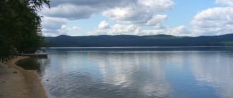
Oz. Uvildy is located within the boundaries of the Argayash and Karabash districts, a few kilometers (along a dirt road) from the city of Kyshtym. Uvildy is one of the most beautiful lakes in the Southern Urals, a favorite vacation spot for workers. Most of the winding coastline is covered with pine and mixed forest. The largest islands are Elovy, Berezovy, Vyazovy, and Morskoy. The area of the lake is 7111 hectares, the average depth is 14 m, the greatest is 39 m (according to other sources, 38.5 m). Transparency 8.2 m. The bottom is sandy, there are pebbles and silt. Kurya (bays) are very silted, their aquatic vegetation is very rich. On the shore there is a fishing base (saima) of a fish factory. Fish: ripus, whitefish, bream, roach, perch, pike, tench, crucian carp, ide, ruff, dace. The weight of the roach reaches 1.5 kg. The ripus grew especially well in the lake. Now it is the main ripus base. Here, fish farmers annually collect tens of millions of ripus eggs for incubation at the Arakul whitefish hatchery. Whitefish caviar is also collected. The following rivers flow into Uvildy: Kamennaya, Kosaya, Anashka. The source is a ditch into the system of Kyshtym lakes. For amateur fishermen, Uvildy is an interesting reservoir in summer and winter. You can always catch a variety of fish here.
Oz. Argazi. It is located in the western part of the Argayash region, near the city of Karabash. On the banks of the village: Bayramgulovo, Turakaevo, Chishma. Argazi is the largest body of water in the Chelyabinsk region. Its area is 10,600 hectares, the average depth, according to some sources, is almost 10 m; according to others - 4 m, the greatest depth is 18 m. The transparency of the water is 10 m. The thickness of the ice in winter reaches 90 cm. The banks of the reservoir are hilly and flat, wooded and bare. There are several islands and bays with wetlands and developed aquatic vegetation. The bottom is muddy. Fish: roach, perch, pike, ide, tench, crucian carp, ruffe, bream, ripus, burbot, pike perch is acclimatizing. There are crayfish. Taimen is very rare, which apparently fattens and grows here, and for spawning it rises into the Miass River and into the left-bank mountain rivers. The lake has a permanent sports fishing base for the Ural Automobile Plant.
Nizhne-Ufaleysky pond in the Ufaleysky district. The pond area is 400 hectares. In terms of its importance, it was the second bream base in the region. During the season, 56 quintals of bream were caught here.
Reservoirs of the Chebarkul fish factory
Oz. Chebarkul . Located near the railway station and regional center of the same name. Travel from Chelyabinsk to Chebarkul by electric train. The duration of the trip is one hour and forty minutes. The area occupied by the lake is 2053 hectares, its length from north to south is 6 km, the greatest width is 3.9 km, the average depth is 6 m, the greatest is 14.8 m. Transparency is 3 m. At the bottom there is silt, sand, pebbles, and shell rock. The bays (kuri) have significant aquatic vegetation. The banks in the south and east are flat, in the west and northeast they are slightly steep. There are rocky headlands. The bottom is uneven. There are several islands. The western part of the banks is wooded. The Elovka River (from Lake Elovoe), the mountain river Kudryashevka, and the Kundurusha River (from Lake B. Elanchik) flow into the lake. Sources: rivers Malkovka, Travyanka, Koelga. Being small, some of them dry out in hot weather. Lake fish: roach, perch, pike, whitefish, crucian carp, tench, ide, carp, bream, ruffe, burbot, ripus, pike perch. Great importance is attached to pike perch breeding here. On the peninsula of the eastern shore there are buildings of the Chebarkul fish factory. An amateur fishing base has been organized on the lake, owned by the Chebarkul Metallurgical Plant.
Oz. Big Elanchik. It is located southwest of Lake Chebarkul. The area is 590 hectares, the greatest depth is 7.9 m. The lake has two reaches - northern and southern. The banks are often steep. At the confluence of the Gryaznukha River, the bank is low and swampy. In the southeast, the Kundurusha River flows out of the lake and flows into Lake Chebarkul. The silt in the lake begins at a depth of two to three meters. The bays are overgrown with reeds. The bottom is uneven. Water transparency is only 1.4 m. Fish inhabit: roach, perch, a lot of pike, whitefish, crucian carp, tench, ruffe, rhipus planted.
Oz. Turgoyak. One of the most beautiful in the Southern Urals. It is surrounded by mountains and coniferous forests. On the shore of a holiday home. The lake is located north of Miass station. The village of Turgoyak is located near it. The area of the reservoir is 2650 (2560) hectares, the average depth is 19.2 m, the greatest is 34 m. Water transparency is 12 m. The bottom is uneven. Soil: sand, pebbles, loam, silt. Thickets of aquatic vegetation are insignificant. The length of the lake is 6.9 km, the greatest width is 6.3 km. There are 6 islands. The largest of them is the island of Vera. Its area is 8 hectares. The following rivers and springs flow into the lake: Bobrovka, Lipovaya, Kulemovsky, Gorelovsky, Inyshkinsky. There are whitefish, roach, perch, ide, pike, ruffe, burbot, gudgeon, tench, ripus, and very rarely trout, which they tried to acclimatize here for a number of years. Every year, whitefish eggs are collected for incubation at the Arakul fish hatchery. To restore the whitefish herd (as in Lake Uvildy with ripus), whitefish larvae are added to the lake every year. The presence of 31 crayfish and ruffe interferes with the breeding of valuable fish.
Oz. Kysykul. Location - north of Miass station, on the road to Turgoyak. The area of the lake is 220 hectares, the average depth is 2.7 m, the greatest is 5.4 m. The shores are mostly rocky. The north-eastern coast is flat. The bottom is flat, muddy, and there is little aquatic vegetation. The Topkaya and Sokolnaya rivers flow into the lake. Fish: roach, tench, perch, pike, crucian carp, carp, bream, ruff. Due to the fact that the automobile plant takes a lot of water from the lake, it becomes shallow and loses its commercial importance.
Polikarpov Pond . It is located a little south of Lake Kysykul, not far from the village. Melentyevskoe. The pond area is 250 hectares, length 3.8 km, width 1.6 km. Depth 3.2 m (at the gateway about 5 m). The banks are low, only on the northern side there is a stone. Along one bank there is a flooded forest. The bottom is dense. There are thickets of aquatic vegetation. Fish: roach, perch, dace, crucian carp, tench, carp, ruff, pike.
Lakes Big and Small Miassovo. Located on the border of the Chebarkul and Argayash districts, to the north from the Chebarkul station (through the village of Nepryakhino to the village of Verkhniye Karasi on Maloe Miassovo). The area of the large reach is 1,150 hectares, length 7 km, maximum width 2.1 km, maximum depth 22.5 m. Area of the small reach 1,123 hectares, length 6.6 km, maximum width 3.4 km, maximum depth 7.7 m The large reach has 3 islands, the small reach has one. 6 rivers flow into the lake: Nyashevka, Chartonyshka, Demidovka and others. There is only one source - in the eastern part of the small reach - the Karasi River, which flows into the Miass River. The lake is surrounded by wooded ridges. The bays have highly developed aquatic vegetation and wetlands. There are rocky headlands and placers. The bottom is mostly muddy. In some deep areas in winter, the presence of hydrogen sulfide is observed in silty sediments. Transparency 6 m. Main fish: roach and perch. There are also whitefish, crucian carp, tench, ide, ruff, ripus, pike, and burbot. Anglers can find good fishing spots on the lake in open stretches of char and holes and in quiet bays. Lake pike perch, planted with larvae in 1956-1957, have not yet been found in the catches. Fishing is allowed only in the Maloe Miassovo reach (from the village of Verkhnie Karasi), since the Bolshoye Miassovo reach is located on the territory of the Ilmensky Nature Reserve.
Oz. Big Kisegach. Located north of Chebarkul station, among the Ilmen Mountains. The area occupied by the lake is 1,420 hectares, the average depth is 12.7 m, the greatest is 34 m. The bottom is clean, silt, sand. Transparency 8 meters. 6 rivers flow into the lake, four of which are from the Ilmen Mountains. The source is the Chartonyshka River, connecting the reservoir with Lake Maly Kisegach. The lake is home to whitefish, ripus, roach, crucian carp, tench, perch, ruffe, pike and many crayfish. The lake has 7 islands, along its shore there is a sanatorium. Fishermen should remember that the western part of the reservoir is adjacent to the Ilmensky Nature Reserve.
Oz. Spruce. Located very close to the city of Chebarkul. Area 322 hectares, length 2.2 km, maximum width 1.9 kilometers, maximum depth 13.5 m. At Okropilovaya Kurya the bank is sloping, in other places it is steep, rocky, and steep. The reservoir does not have constant flow. At the bottom there is silt, sand, pebbles. There are reeds along the banks. Mainly roach and pike are found. Lots of burbot. There are also crucian carp, tench, ide, ruffe, perch, and crayfish. Whitefish planted. The lake has three islands.
Oz. Big Sunukul . Location - Chebarkul district, near the village of Pepryakhino. The reservoir consists of two lakes (reaches), connected by a channel 15 m wide and 0.5 m deep. In summer, this channel often dries up and freezes in winter. The northern part of the reservoir is called the Big Reach, the southern part is called the Small Reach. The lake has three islands. Their total area is 21 hectares. The area occupied by the reservoir is 739 hectares, its transparency is 2 m. The length is 5.7 km, the greatest width is 2.5 km. The greatest depth in the Big Reach is 7 m, in the Small Reach - 3 m. In the Big Reach the banks are gentle, in the west they are steep and rocky, in the north-west there are rafts. In Maly Reach the banks are low and swampy. The bottom is flat and muddy. The tributary is Kopanets, dug from Lake Maly Sunukul, located northwest of Big Sunukul. There are no origins. The lake contains roach, crucian carp, tench, perch, ruff and pike. Carp planted. In addition to the lakes mentioned above, the reservoirs of the Chebarkul fish factory include many others. But they are either smaller in surface area or have poorer fish species. In the west of the region in the Satka district, the fish factory owns the mountain lake Zyuratkul. Its area is 700 hectares, the average depth is 3.4 m, the greatest is 12 m, transparency is 6.5 m. The lake is home to pike, perch, roach, ide, burbot, and hybrid rhipus is planted.