Detailed map of the Vladimir region
More than half of the area of the Vladimir region is occupied by forests, which have a beneficial effect on the environmental situation.
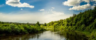
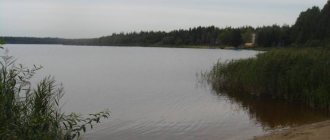
Many representatives of mammals, birds and fish live in this area, rich in natural resources. On the territory of the Vladimir region, many zones have the status of protected areas and resorts. Here is the Meshchera National Park, which represents the abundance of vegetation of the Vladimir forests. In various nature reserves, plants are cultivated and conditions are created to increase the number of wild animals and birds. The Vladimir region is rich in water resources. There are several hundred rivers in it, their total length is 8560 km. All of them belong to the Volga basin, which in turn is part of the closed Aral-Caspian basin. The main rivers of the Vladimir region are the Klyazma and Oka rivers. There are also about three hundred lakes in the region. They are all mostly small, there are no large lakes. The shapes of lakes are different: oval, round, horseshoe-shaped. The shores are sandy or marshy. The deepest and largest lake is Kshara. Main cities and towns of the Vladimir region (click on the city name to go):
Detailed map of the Vladimir region:
The area of the region is 29,084 square kilometers, and the population according to 2013 data is about 1,421,742 people. In the north it borders on the Yaroslavl and Ivanovo regions, on the southern side it has the Ryazan region as neighbors, and as for the east and west, it is met there by the Nizhny Novgorod and Moscow regions, respectively. The largest cities and industrial centers of the Vladimir region include Vladimir, Alexandrov, Kovrov, Murom, Vyazniki, Kolchugino, Gus-Khrustalny.
Source
Water bodies of the Vladimir region
The territory of the Vladimir region is entirely located within the Upper Volga basin.
The river network of the region is represented by 746 rivers with a total length of about 8.6 thousand km (the density of the river network is 0.3 km/km2), most of which are small rivers and streams. The rivers of the region are flat in nature, many of them are regulated by dams of small reservoirs and ponds. Most rivers are usually high-water, but their water content varies greatly within and between years. The rivers are characterized by mixed feeding with a predominance of snow (55%).
The rivers of the Vladimir region belong to the Eastern European type of water regime, they are characterized by high spring floods, summer-autumn low water, interrupted by rain floods, and low winter low water. Rivers freeze at the end of November, open in early - mid-April, and in some years many rivers freeze to the bottom. The largest rivers in the Vladimir region are the Oka and its tributary, the Klyazma.
The average long-term river flow is 35.2 km3/year. In 2015, river flow in the Vladimir region amounted to 25.5 km3/year, which is 27.56% lower than the long-term average. In terms of river flow in 2015, the Vladimir region ranks third after the Ivanovo and Kostroma regions. Below is the dynamics of river flow in the Vladimir region from 2010 to 2015.
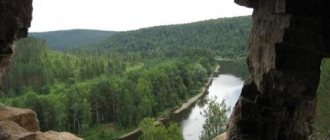
One of the largest rivers in the region is the Klyazma, flowing in the direction from southwest to northeast (length within the region is 392 km). The Klyazma flows into the Oka on the southeastern outskirts along the border with the Nizhny Novgorod region. The largest tributaries of the Klyazma: Sherna (with the Molokcha tributary), Kirzhach (with the Big and Small Kirzhach tributaries), Peksha, Koloksha, Nerl, Sudogda, Uvod, Lukh, Suvoroshch.
On the southeastern outskirts, the Oka River flows along the border with the Nizhny Novgorod region. The Oka River within the region is navigable along its entire length (157 km). The main tributaries of the Oka: Gus, Buzha, Unzha and Ushna. The Dubna River, a tributary of the Volga, originates near Alexandrov.
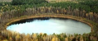
Karst lakes are located in areas where limestones occur. They are small, have a rounded shape, steep banks, and significant depth, which starts from the shore. They are distinguished by the variability of water levels, which is due to the influx of groundwater that feeds them. Their water is highly mineralized, as lime is dissolved in it. Such lakes are found in the lower reaches of the Klyazma and in the center of the Vyaznikovsky district (northeast of the region). They are often connected to each other by underground drains. Such lakes are located in groups. The largest and deepest of them is Lake Kshara, its depth is 65 meters. In the Meshchera Lowland and in the north-west of the region there are lakes of ancient alluvial valleys: Isihra, Svyatoe, etc. In the Aleksandrovsky and Yuryev-Polsky regions there are lakes of glacial origin of small size.
Fishing, hunting, active recreation on the lakes of the Vladimir region
The Vladimir region is rich in water resources. These are mainly rivers of the Volga basin. In addition to them, there are more than 300 lakes in the region. The lakes in the Vladimir region are mostly small floodplain ones. However, many of them are very deep. The deepest is Kshara, which has a depth of up to 65 meters. The largest lakes are Svyatoe, Kshara, and Velikoye, although they can be attributed to this category purely theoretically.
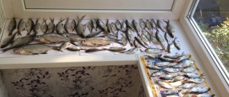
Fishing in the Vladimir region includes more than 40 species of fish that are found in reservoirs. However, it is not always possible to fish in the region everywhere and not always. For example, on the largest lake, Svyatoye, there are restrictions on catching certain types of fish throughout the year. But during the permitted time, asp, bream, pike perch, and ide are caught here. There are pike and freshwater catfish. The second largest lake in the region, Velikoye, is also known for limiting fishing during the spawning season. The fish species in these lakes are the same. Those who want to fish in accessible and more comfortable conditions go to Lake Glubokoe. Services for organizing fishing here are paid. Fish of carp and perch species are released. Not everyone likes this kind of artificial fishing, but, as they say: “Tastes are a matter of taste.” Before you go fishing in the Vladimir region, you need to check the spawning schedule and fishing bans.
Source
Where to fish for free
Oka River
On the Oka you can catch carp, crucian carp, pike, bream, chub and rudd. Fishermen also boast about their catches of carp, catfish, bream, grass carp, and tench.
Oka River
Flowing through several regions, namely in the Vladimir region, in the area of the village of Dmitriev Mountains, the river is rich in roach, pike perch, barbel, ide and burbot.
Nerl River
In the cleanest river, even a beginner will catch his first roach, large chub, pike or bream. It is believed that the Suzdal region of the region is the richest in catches; silver bream and carp are found there; tench, perch and crucian carp are caught there; dace, gudgeon, ruffe and bleak are often pecked near Mordvinovo.
Lake Velikoye
The lake is famous among fishermen and outdoor enthusiasts. Large rotan, tench, pike and roach are often found in the reservoir. The bottom of the reservoir is at least silted, does not have sharp changes and is quite flat.
Lake Kshara
The freshwater reservoir with clean and clear water goes almost 70 meters deep and is famous not only for fish, but also for crayfish. In addition to the record size of pike and giant perch, in the lake you can find roach, ide, burbot, ruffe, dace and other species of fish.
Lake Maloye Vinnoe
The lake is suitable for fishing for loach, rudd, crucian carp, bream, burbot, tench, roach, ide, pike and perch. You can fish both from a boat and from the shore. The shore of the reservoir allows you to comfortably pitch your tent. The bottom of the reservoir is clean.
Kolp River
This small river is small, but the fishing amazes both the novice and the experienced angler. Pike, perch, roach, chub, bleak and rudd are caught in the river. At the beginning of summer and after heavy rainfall, the river is especially deep, which makes it very attractive for fishing.
Lake Isihra
Lake Isihra is famous for fishing for roach, perch, ide and pike. The reservoir is quite shallow and has a marshy shore, as peat quarries are located nearby. It is most convenient to fish from a boat; for others, fishing from the shore with feeder gear or spinning rods is suitable.
Lake Vvedenskoye
Active fishing is guaranteed on this lake. The catch is varied: tench, carp, roach and here and there bleak. Fans of spinning fishing can count on perch. Although the season for abundant pike fishing with mugs ends by mid-July, thanks to the large area and calmness of the reservoir, it will not be boring.
Lake Vvedenskoye
Fishing in neighboring regions: Ivanovo, Moscow, Nizhny Novgorod regions.
Rivers of the Vladimir region
All rivers of the Vladimir region belong to the Volga basin. Their total length is more than 8,500 kilometers; many have an extended network of rivers with a large number of branches. Geographically, there are 115 small rivers in the Vladimir region. The rivers that are considered the most significant in terms of resources needed by the population are the Klyazma and Oka. The Volga-Baltic trade route seemed to be a significant link in the economic, cultural and political spheres. Rivers connected and maintained relations between near and distant lands and the northern and eastern regions. To establish mutually beneficial connections with their southern neighbors, they went from Klyazma to the Oka, and from there to the Volga. The rivers of the Vladimir region were transformed in an economic and cultural direction in order to improve the standard of living of the local population. The main problem of the Vladimir region is the increased level of river clogging. Thermal, agrotechnical and thermal pollution are more common. Reservoirs contain a high percentage of arsenic and mercury. For this reason, the ichthyofauna has decreased ten to fifteen times, and many rivers have become unsuitable for consumption. Currently, activities are being carried out to improve the ecological environment, rivers are being cleared of factory waste and garbage, and reservoirs are being deepened.
Where in the Vladimir region you can swim in 2021
In the Vladimir region, abnormally high temperatures have continued to persist for almost a week now, the cause of which was a powerful crest of a subtropical anticyclone from the Iranian Plateau. In the heat, people go swimming much more often, sometimes giving preference not to officially approved and approved places, but to bodies of water that are familiar and geographically close.
The Ministry of Emergency Situations for the Vladimir Region reported that since the beginning of the swimming season, 15 people have drowned, five of whom are children. The department believes that municipalities are not taking enough action to prepare beaches and are proposing to block the entrances to unauthorized places for recreation near the water.
We urge all citizens to be careful, remember water safety rules and closely monitor their children, as well as choose proven beaches for swimming. In total, there are 46 places allowed for swimming in the region in 2021. We suggest you familiarize yourself with all of them or use the page search using Ctrl + F.
Vladimir
- Pond No. 41 Verkhniy Semyazinsky (27A Prigorodnaya Street);
- Sodyshka Reservoir;
- Lake Glubokoe in the Country Park;
- Klyazma River Upper backwater.
Gus-Khrustalny
- Reservoir on the Gus River.
Gus-Khrustalny district
- A reservoir in the village of Mezinovsky.
Kovrov
- Microdistrict Zarechnaya Slobodka, southern shore of Lake Starka.
Kovrovsky district
- A reservoir in the village of Melekhovo.
Moore
- Embankment in the area of the left bank of the Oka River, exit along Vorovskogo Street, upstream of the river.
Muromsky district
The opening of the swimming season was promised only after the high alert regime was lifted.
Alexandrovsky district
- Lake Dichkovskoe;
- Andreevskoe Dam;
- Krutets Dam.
Vyaznikovsky district
- City beach in Vyazniki in the backwater of the Klyazma River, 150 meters to the left of the rescue station;
- The Msterka River in the village of Mstera, about 50 meters from the border of house No. 1B on 2nd Naberezhnaya Street;
- Zelenino reservoir, Nikologory village;
- A reservoir on the northern outskirts of the village of Stepantsevo;
- Tara River, Okhlopkovo village;
- Bakhtalovskaya Dam, Bakhtalovo village;
- Staryginskaya dam, Luknovo village.
Gorokhovetsky district
- Gorokhovets, Naberezhnaya street (200 m from the rescue post downstream of the Klyazma River).
Kameshkovsky district
- Pond in the village of Mirny, Tsentralnaya street;
- Lake Maloye Ursovo, town of Kameshkovo;
- Lake Perekhanovo.
Kirzhachsky district
- Kirzhach River in the city of Kirzhach;
- A pond in the village of Dubrovka.
Kolchuginsky district
- Reservoir on the Peksha River;
- Bavlensky Pond.
Melenkovsky district
- Melenki, left bank of the Unzha River, in the area of 40 Let Oktyabrya Street;
- Lyakhi village, 100 meters – left bank of the Oka River;
- Village Butylitsy, Ushna River;
- Left bank of the reservoir (GTS) in the village of Denyatino;
- 300 meters from the village of Kononovo in the northwest area of the Kononovskoye Reservoir (GTS).
Petushinsky district
- Pokrov, Black Lake;
- Nagornoye rural settlement, Glubokovsky quarries, farm "Birch Paradise";
- Nagornoye rural settlement, a water body near the village of Sanino.
Selivanovsky district
- Krasnaya Gorbatka village, Kolp River, Krasnogorochka recreation area;
- Krasnaya Gorbatka village, Kolp River, Zemlyanina recreation area;
- Tuchkovo village, Kolp river, “Tourist” tent camp (10 days in July).
Sudogodsky district
- A section of the Sudogda River in the area of Naberezhnaya Street;
- Section of the Sudogda River, the town of “Krucha”;
- Chernaya River, Pogrebishchi village.
Suzdal district
- Kamenka River in Suzdal;
- Village of Novoye municipal district Bogolyubovskoye, upper pond;
- Nerl River, Yakimanskoye village;
- Omutskoye village, Seletskoye municipal district, Nerl river.
Yuryev-Polsky district
- The Gza River in the village of Entuziast.
Tags
Aleksandrovsky district Vyaznikovsky district Gorokhovetsky district Gus-Khrustalny district Kameshkovsky district Kovrovsky district Kolchuginsky district Melenkovsky district Muromsky district Ministry of Emergency Situations Petushinsky district Selivanovsky district Sudogodsky district Suzdal district Yuryev-Polsky district
Vladimir region: main nature reserves and parks
An excellent reason to visit the Vladimir region is its protected places. It seems that the pristine nature of ancient nature is concentrated here.
Meshchera National Park
- Coordinates on the map: 55.561111, 40.253889.
The Meshchera Lowland is an amazing kingdom of nature, a land of rivers and lakes, swampy plains and forests. In 1992, a national park was created in these territories, which was named Meshchera. At that time, its area occupied only 100 thousand hectares. Today it is almost 300 thousand hectares of natural land.
Visitors are treated specially here. They are shown not only natural attractions and ecological routes, but also introduced to the life and customs of our ancestors. For example, in the village of Tasinsky there is a unique local history complex, and it also belongs to the Meshchersky National Park.
This is a real ancient Russian village, in which all the buildings are made in miniature. Here you can not only see how the ancient Slavs lived, but also play ancient Russian games, and even watch a theatrical performance.
Bogolyubovsky meadow
- GPS coordinates: 56.191904, 40.554408.
In the Suzdal region - where the Nerl and Klyazma rivers connect - there is one of the most beautiful corners of the Vladimir region. Bogolyubovsky Meadow became a protected area more than half a century ago, but few people guess what, besides the beautiful landscapes, was the reason for this.
The fact is that here, in one place, more than 300 species of rare plants have been collected, several are even listed in the Red Book. Not to mention the amazing Church of the Intercession on the Nerl, which stands in the middle of this splendor.
Klyazminsko-Lukhsky reserve
- Coordinates: 56.341944, 42.356389.
The Balakhninskaya Lowland is a habitat for rare animals and plants listed in the Red Book; beautiful lakes of great hydrological importance; wetlands and woodlands.
Of course, these are amazingly beautiful landscapes that can only be seen here, where Klyazma and Lukh merge into a single whole. Since 1994, these places have become a specially protected area, which was created with the aim of preserving and enhancing this amazing natural beauty.
Patriarchal Garden
- Coordinates: 56.124873, 40.401263.
The real pearl of Vladimir is located in its historical center, next to Kozlov Val. The beautiful garden, in which, in addition to the traditional Russian fruit trees and shrubs, grows such exotics as almonds and Manchurian walnuts, is called the Patriarchal Garden.
Its name goes straight back to ancient times, when each monastery had its own garden. This one was no exception. Apparently, its history began in the 12th century, under Prince Andrei Bogolyubsky. It was he who brought cherry trees from Kyiv, which today have become the hallmark of the garden. But if you believe the documents, then it is a little over four hundred years old.
Free fishing in the Vladimir region
The water resources of the Vladimir region are extensive; there are more than 300 lakes in the region. There are also many rivers, all of them belong mainly to the Volga basin. The reservoirs are mostly large, but there are also plenty of small ones, which makes it possible for many species of fish to grow and reproduce. Accordingly, fishing is extremely popular; everyone, young and old, fishes here.
In general, today in all the reservoirs of Vladimir you can count about 40 species of different fish. Mainly bites: dace, crucian carp, ruffe, burbot, perch, tench, roach, gudgeon, bleak, silver carp, ide, pike. Of course, not every place is suitable for fishing; in some places there are restrictions on fishing.
Here are the TOP 10 best places where you can fish for free in the Vladimir region:
Oka River
Description, what kind of fish is found, how to get there:
In the Oka there are such species of fish as carp, crucian carp, cupid, bream, chub, carp, rudd, tench, roach, barbel, ide, pike perch, perch, burbot, catfish, pike, and crayfish. One of the best places for fishing is considered to be in the area of the village of Dmitrievy Gory in the Melenkovsky district.
GPS coordinates: 55.3359, 41.939
Nerl River
Description, what kind of fish is found, how to get there:
The river has clean water and a lot of fish. Fishermen can count on roach, pike, chub, bream, silver bream, crucian carp, dace, carp, gudgeon, tench, bleak, perch and ruff. The most fishing places are located in the Suzdal district of the Vladimir region. The fishermen will definitely not leave here empty-handed.
GPS coordinates: 56.74921, 39.49553
Klyazma River
Description, what kind of fish is found, how to get there:
Klyazma River
It belongs to the Caspian Sea reservoir and is a tributary of the Oka. It is considered the main river in Vladimir, its central water link. Vladimir stretches along the coastline, dividing the Vladimir region into 2 zones of different sizes: northwestern (smaller) and southeastern. On the left coast is the oldest central district, which reflects development, architectural, social, cultural heritage.
- The length is 686 kilometers, the river valley is narrow and contains almost 43 thousand square km. water;
- The width of Klyazma near the Klyazma basin is 12 meters. Near the Moscow railway tracks (Moscow-Yaroslavl direction) it expands to 20 meters;
- The average fluid consumption throughout the year reaches up to 147 cubic meters per second. Water consumption is calculated at Kovrov, which is located 185 km from the final section of the river;
- The snow type of nutrition is mainly carried out due to the external movement of water and precipitation from the atmosphere, as well as groundwater;
- It rises at the end of autumn and thaws in the first ten days of April. Not covered with ice from 210 to 215 days.
Description
The Moscow Upland is the starting point at which the Klyazma begins its course (near the Solnechnogorsk region). From the initial section in the Solnechnogorsk area the direction is south-east, in the Molzhaninovsky district it turns to the east. It flows through the Klyazma and Pirogov basins, after which it flows into the Volga. Klyazma runs along the Meshcherskaya Plain. Below the Ivanovo region, near the low left bank, is the Balakhninskaya Plain. On the right side, near the Gorokhovetsky fort of the East European Platform, the coast has a height of approximately 90 m, in the Vladimir region 130 meters, in some areas the steep banks exceed 200 meters. The coastline of the upper embankment is high, the river bottom composition is predominantly clayey, and there are small sandy areas. In some areas it passes through limestone rocks. The pool is shallow (mostly up to two meters, maximum depth is eight), swimming vessels have the ability to move from the final section to Vladimir. The previously popular trade route from Klyazma to Skhodnya and Moscow is currently not used, since since then the water level has decreased significantly. It has many tributaries. The following flow into it: Lukh, Nerl, Tara, Bolshoi Kirzhach, Sudogda, Vorsha, Nerekhta, Koloksha and others.
In the still waters... The most mysterious lakes of the Vladimir region
There is Nessie in Scotland. In Denmark - the little mermaid. Why are we any worse? According to Dmitry Savva, a researcher of anomalous phenomena, there are many strange and even frightening bodies of water in the Vladimir region. These are the ones we will tell you about now.
Monster from the underground river
In the Vyaznikovsky district, not far from the town of Pivovarovo, there are several small lakes, which until recently were favorite “spots” for fishing. But increasingly, residents of surrounding villages are choosing other places to hang out with a fishing rod. And it wasn’t the fisheries inspection that drove them away...
The same area
“People who don’t know each other tell the same story. We were sailing on a boat along a small lake and stopped to go fishing. Suddenly, something completely different from a fish appeared above the water, the head of some large animal. “Something” was at least the size of an adult man’s head. And under the water, most likely, a large body was hidden. It’s as if the legendary Loch Ness monster moved from Scotland to our region.
Of course, first of all we assumed that we were talking about an ordinary large catfish. But a huge fish cannot survive in a small body of water. Moreover, if there is no connection with the rivers and the predator has nowhere to swim from. And here’s another mystery: there are several lakes where the “miracle Yudo” was seen. Yes, they are all located in the north of the Murom region. But either there are several strange creatures, or it somehow moves from one body of water to another. The second version seems more logical to me. In that area, there are many karst caves underground; underground rivers flow into them, which may well connect several above-ground lakes into a single chain. What if, by some miracle, a relict creature, a distant relative of Nessie from Loch Ness, survives in this water system? This version remains to be verified.”
The lake that disappeared with the fish
If the monster described above has not yet been caught or even photographed, then the case with Lake Sakantsy is well documented.
“This reservoir was located in the Vyaznikovsky district. Its depth reached 3-4 meters. But literally in an instant all the water left and even the fish disappeared! Yes, it sounds strange, although there is still a logical explanation for this. It's all about the same karst caves. Perhaps one of them was located under the lake. But over time, the vaults were washed away, and the ground simply collapsed. The water and fish “went” into an underground source. This is not the first case in that area - the Pivovarovsky failure is located next door. This is a huge pit into which a 9-story house can easily fit. By the way, sometimes reservoirs return to the surface. So, in the Gus-Khrustalny district, the lake first collapsed, and after a few years it filled with water again.”
Mermaid Lake
This story is worthy of film adaptation. It's a pity that it won't be a romantic Disney cartoon about a good little mermaid, but a real thriller.
The story of a girl who saw a mermaid
“This lake is actually called Vekhnya. The word, by the way, is scary - it comes from a very poisonous plant “vekh”. That is, it can be assumed that many generations of people were afraid of this body of water. But the “mermaid” appeared in it relatively recently. First, people found the dead girl in the water. And then some of them saw something like a ghost.
Eyewitnesses say that on a summer night the silhouette of a woman in a white dress wandered over the water - from the center of the reservoir it reached the very shore. But why not a ghost, but a mermaid? According to legend, these creatures lure men into the water and drown them. Local residents are sure that the same thing is happening on Lake Vekhnya. Indeed, for some reason, it is the representatives of the stronger sex who most often die in this place. We conducted two expeditions to the lake shore and spent the whole night there. But, unfortunately or fortunately, no one came out of the water to us.”
Apparently, there are places in our region where the saying about the still waters and the evil spirits that live there can be taken literally. Although, we do not exclude the possibility that all these oddities will someday be explained by science.
*photo: pixabay.com | vk.com/savvadmitrii
Fishing in the Vladimir Region | Top Best Fishing Spots
Oka River | Main Artery of the Region
This river is considered the most important waterway in the region. It flows near the main city of the region, so local city residents often spend their leisure time here.
But as for fishermen, they are rare, although the fish composition of the Oka is very diverse, the fish bite quite well, and there is no competition at all between fishermen.
Source
Vladimir region
The Vladimir region is a subject of the Federation in the center of the European part of Russia.
The region is located in the Volga-Oka interfluve; the territory is a gently undulating plain. In the north-west of the region there is the Smolensk-Moscow Upland, in the interfluve of the left tributaries of the Klyazma, Nerl and Kirzhach - the Vladimir Opole, in the south of the region - the Meshcherskaya Lowland. The Vladimir region is part of the Central Federal District. The administrative center is the city of Vladimir.
The region's territory is 29,084 km2, the population (as of January 1, 2021) is 1,389,599 people.
Surface water resources
The territory of the Vladimir region is entirely located within the Upper Volga basin.
The river network of the region is represented by 746 rivers with a total length of about 8.6 thousand km (the density of the river network is 0.3 km/km 2 ), most of which are small rivers and streams. The rivers of the region are flat in nature, many of them are regulated by dams of small reservoirs and ponds. Most rivers are usually high-water, but their water content varies greatly within and between years. The rivers are characterized by mixed feeding with a predominance of snow (55%). The rivers of the Vladimir region belong to the Eastern European type of water regime, they are characterized by high spring floods, summer-autumn low water, interrupted by rain floods, and low winter low water. Rivers freeze at the end of November, open in early - mid-April, and in some years many rivers freeze to the bottom. The largest rivers in the Vladimir region are the Oka and its tributary, the Klyazma.
The average long-term river flow is 35.2 km 3 /year. In 2015, river flow in the Vladimir region amounted to 25.5 km 3 /year, which is 27.56% lower than the long-term average. In terms of river flow in 2015, the Vladimir region ranks third after the Ivanovo and Kostroma regions. Below is the dynamics of river flow in the Vladimir region from 2010 to 2015.
According to the Institute of Lake Science of the Russian Academy of Sciences, on the territory of the Vladimir region there are more than 2,250 lakes and artificial reservoirs with a total area of about 95 km 2 (lake content 0.32%), including 400 lakes with an area of more than 0.01 km 2 and a number of smaller lakes of various sizes origin: oxbow lakes in river floodplains, glacial lakes, lakes of ancient alluvial valleys, as well as karst lakes. The largest lake in the Vladimir region is the Holy Lake (up to 10 km 2) at the source of the river. Pry (a tributary of the Oka River), located on the border with the Moscow and Ryazan regions. The largest artificial reservoirs in the region are the Kolchuginskoe reservoir on the river. Pekshe and Latyrevsky pond on the river. Birch.
Swamps and wetlands occupy 1.32% of the territory of the Vladimir region (383 km 2). Here is the large Vyaznikovsky group of swamps - the largest swamp massif in the region, the territory of which has never been subjected to drainage reclamation and peat mining.
The area and number of lakes and artificial reservoirs, swamps and wetlands are variable; they depend on natural (water regime, climatic phenomena, swamping, meandering, etc.) and anthropogenic (drainage of territories, creation of new artificial reservoirs, etc.) factors.
Groundwater resources
The forecast groundwater resources of the Vladimir region are 3260 thousand m 3 /day (4.4% of the total volume of forecast groundwater resources in the Central Federal District and 0.37% in Russia). Groundwater reserves Groundwater reserves are the explored and studied part of the forecast groundwater resources that have passed the state examination. regions as of January 1, 2015 amounted to 1644.4 thousand m 3 /day, which corresponds to a degree of study of 50.44% - the second indicator among the regions of the federal district after the Moscow region.
According to data as of January 1, 2015, 379.7 thousand m 3 /day were produced and extracted from underground water bodies of the Vladimir region over the year, including 255 thousand m 3 /day from the fields. Degree of development of groundwater reserves The ratio of the volume of groundwater extracted at fields (sites) to the groundwater reserves of the territory. is 15.51%.
Provision of population with water resources (according to 2015 data)
The provision of the region's population with river flow resources is 18.251 thousand m 3 /year per person, which is lower than the Russian average (31.717 thousand m 3 /year per person), but significantly higher than the indicator of the Central Federal District (2.082 thousand m 3 /year per person ). According to this indicator, the Vladimir region ranks third among the regions of the federal district after the Kostroma and Ivanovo regions.
The provision of predicted groundwater resources is 2.333 m 3 /day per person, which is also lower than the Russian average (5.94 m 3 /day per person), but higher than the figure for the federal district (1.894 m 3 /day per person).
Below is the dynamics of provision of the population of the Vladimir region with river flow resources in 2010–2015.
Water use (as of 2015)
Abstraction of water resources from all types of natural sources in the Vladimir region - 157.55 million m 3. A significant part of the water was taken from underground water sources - 114.97 million m 3 or 72.97%. Below is the dynamics of fresh water intake in the Vladimir region.
Vladimir region
The total surface water surface of the Vladimir region is 32.9 thousand hectares. The main rivers of the region are the Klyazma and Oka. The catchment area of the Oka River within the region is 5930 square meters. km (out of 245,000 sq. km), the Klyazma River - 27,070 sq. km. km (out of 41,600 sq. km). The length of Klyazma across the region is 459 km, Oka - 157 km. Hundreds of large and small rivers flow through the region with a total length of more than 8.6 thousand km (their number, together with streams, reaches 746). The Klyazma flows into the Oka on the southeastern outskirts along the border with the Nizhny Novgorod region. The largest tributaries of the Klyazma: Sherna (with the tributary Molokcha), Kirzhach (with the tributaries Big and Small Kirzhach), Peksha, Koloksha, Nerl, Sudogda, Uvod, Lukh, Suvoroshch, tributaries of the Oka: Gus, Unzha and Ushna, near Aleksandrov the tributary of the Volga originates Dubna river. 137 reservoirs and ponds with a total volume of 89.664 million cubic meters were built on the rivers of the region. m.