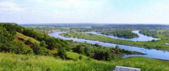
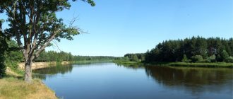
Pascal once said a brilliant phrase: “Rivers are roads that themselves move and carry us where we are going.” The Pra River is a “highway” through picturesque places where the Moscow, Ryazan and Vladimir regions come close to each other. Historically, the Klepikovsky district of the 62nd region is called the Ryazan Meshchera. The second word is an ethnonym, hinting at a fairly large Finno-Ugric tribe that lived here.
The smallest (northwestern) part of the reservoir flows through the territory of the Shatursky municipal district of the Moscow region. Almost the entire rest of the channel lies in the Klepikovsky district of the Ryazan region (the mouth is already in Spassky). The Pra River is a left tributary of the Oka. Its slope is insignificant. Food - only snow. Therefore, the current speed is 2-3 kilometers per hour. However, the flow is weak but winding: at some points the parameter can reach 5 kilometers per hour. The average depth is 1.3 meters. In the area of the throat - up to 2 meters. The total length of the channel is 167 kilometers. The catchment area is 5,520 square kilometers (there are several branches). The names of the Meshchera rivers are more of Finnish origin. It is all the more surprising to find among them “pra” - an idiom denoting age seniority in the Slavic (essentially Aryan) language. Apparently, this was the first Meshchera river colonized by the Russians.
Another version nevertheless “subordinates” the hydronym to the language of the indigenous Meshcheryaks, linking it with the concept of “head”. Perhaps here (among the Finno-Ugrians of the Ryazan principality) the Pra River was the most important artery, connecting all their ancestral villages, which later became towns - Chebukino, Kaldevo, Spas, Klepiki, Ekshur and Podgorye. Proulx was best described by Paustovsky - the “singer” of Meshchera. He called it the most “virgin and mysterious”... In Soviet times, canals were built from the most swampy shores, leading to local fields.
Source and mouth of the Pra River
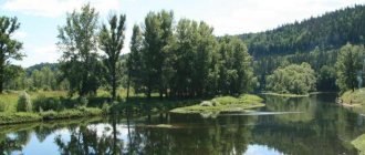
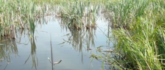
The water body is born from the resources of two lakes – Svyatoy and Dubovoye. Together, these bowls form a curving expanse of water about 15 kilometers long! The river “start” can be seen from the Yegoryevskoye Highway - at the southeastern entrance to the village of Meshchersky Bor. The nearest settlement is the village of Korenets. Swamps approach this unique location from the south (after all, we are talking about lowlands). Islands of reeds form on the water. Moreover, to the west of the named village, the Pra River itself expands to the size of a lake (the maximum spill diameter is 1.66 kilometers). To the north are thickets of river reeds. Forest from the southwest. There are swamps in the south. An agricultural canal running from this point feeds the fields of the village of Ivanovo. It is so beautiful here that visitors usually stop to take photos, and in warm weather, even to swim.
The mouth of the Pra River is located in the Spassky district of the Ryazan region - a few meters southeast of the horseshoe-shaped fragment of the old Oka riverbed. This is the Spatula. This oxbow has long been recognized as one of the most colorful tracts of the Ryazan Meshchera, attracting both fishermen and swimmers. As for the entrance of the described reservoir to the Oka, it is narrow, but at the same time quite deep (2 meters). In the river there is an island (wooded, 145 meters in greatest diameter)... A small creek has formed to the southwest. In late spring, the entire visible area is under water (we are talking about a loan). The nearest settlement is Brykin Bor. From here the river goes most tortuously, making 51 bends in a relatively short section of the route! By the way, on the opposite bank of the Oka there is a higher kilometer-long sandy beach, long favored by tent campers.
Pra River Basin
Beyond the “spill” part, the Pra River again does not exceed 10 meters in width. Goes to the southwest. Among the small fields of the Great Court, it expands to 100 meters, and later absorbs Yalma. A mixed forest appears along the eastern shore, consisting of thickets of alder, birch and aspen. And the spruce forests go in small groups at a short distance. The 12-kilometer Moscow section of the flow has been completed. Further (already in the Klepikovsky district of the Ryazan region) the river tends to the south, southeast, and east, as if “bypassing” the tiny villages of Knyazevo, Gorki and Abrakhovo. It meanders between the other 8 Klepikovsky lakes. Note that passing through Lake Sokorevo, the river basin overflows again and expands at Chebukino to 100 meters. At the same time, he goes a little further into the lowland.
In the vicinity of Averkievo, the reservoir is divided by swamps into 2 channels. In the area of most Klepikovsky lakes, its shores are inaccessible - up to the very south-eastern outskirts of Manshchino (but there are also rare solid areas). “Pravskaya” water acts as wide (up to 100 meters) inter-lake channels. There are a dozen villages in the immediate vicinity. There are already more birch forests here. The last feature is the constant availability of extensions.
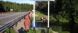
In the middle reaches (from the regional center of Spas-Klepiki) the Pra River has a width of 30-40 meters. More and more islands are found in the channel. There are several bridges across it. Closer to the new swamp area you will come to “cordon 273” - a memorable part of the Meshchersky National Park. Here (in the forester’s booth) Konstantin Paustovsky spent a lot of time, writing his best works. Mighty pine trees surround the stream on both sides. Far away (to Deulino) the water flows through a dense coniferous forest. The approaches to the shoreline are convenient (in all seasons except spring). A large network of canals appears on the eastern side. And even further, on the border of the Klepikovsky and Spassky districts, there are steep sandy beaches (the reservoir cuts through the more elevated part of Meshchera for some time).
To the east, the Pra River basin consists of continuous “crossroads” with tributaries. By the way, we indicated only Yalma, but there is also Urazh (on the same side) and a lot of left branches (Belaya, Kad, the river U Kordon Elovka, Vorovka, Sovka and Buzha). Don’t forget about the Klepikovsky lakes, which also share water with the Pra River.
In the Spassky district (lower reaches), the green floodplain of the river, being only 500 meters wide in the upper reaches, expands to 4 kilometers, turning into a dense reed-forested area of the Oksky State Reserve. On one side the shore is also covered with spruce forest. The other side of the riverbed is hidden in low-growing willow, aspen, alder, and dense meadow grass. The banks are swampy all the way to Brykin Bor. Further entry into the water is ideal right up to the mouth. The bristlecone, white aspen, the thinnest naiad and chilim (water chestnut) are today listed in the Red Book of Russia.
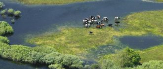
Speaking about fauna, it is worth adding that along its entire length the Pra River is the habitat of a relict inhabitant of the taiga - elk, as well as rare roe deer. The wild boar is an introduced animal. Among the predators there are wolves, foxes, raccoon dogs, hare (hare) and badgers. Today, these regions are increasingly visited by violent brown bears. From fur you can find the muskrat. All birds are meadow, forest and swamp. Lots of cranes. The most characteristic of Meshchera are waders, black grouse, hazel grouse, and kingfishers. The Red Book includes Russian muskrat, black-throated loon, black stork and curlew. There are the eagle owl and the gray shrike, which can only be seen at night when the forest area is suddenly illuminated.
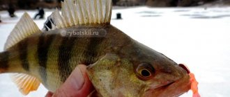
River Pra Ryazan region fishing
The lake is located in the Klepikovsky district, 100 kilometers from Ryazan. The lake is the largest in the Klepikovsky lakes complex. The lake covers an area of approximately 20.4 km, the approximate dimensions of the reservoir are 10 by 4.5 km, and the length of the coastline is about 34 km.
The lake connects two rivers, at the entrance the Vozha River, at the exit with Lake Shagara and through canals with Lake Beloye. There are several small and one large island (Beryozovy) on the lake. The banks are swampy and overgrown with grass.
The origin of the lake is thermokarst, its formation is about 10,000 years old.
On the territory near the village of Prudki there is the Meshchersky state reserve.
Sights of the Pra River
If you explore the source of the Pra River, at the same time explore the Tikhvin Cathedral. It is on the other side of the Yegoryevskoye Highway (only 300 meters from it). Sergei Yesenin especially appreciated the place. As you know, the poet adored the Ryazan region, personifying it with the “real” Russia. What can we say about the cathedral itself? It was originally founded back in the 1890s. Reconstructed to resemble the original (that is, in pseudo-Russian style). It has five domes with hipped domes.
Both recreational and historical holidays on the Pra River are at your service if you reach Spas-Klepikov. In the provincial town there is a museum of wooden architecture. And two more “business cards” - the Church of the Transfiguration of the Lord and the S. Yesenin Museum (ancient buildings where he was raised and studied). 2 kilometers below Makeevo you will find a fairly wide sandy beach. You can have a picnic and spend the night.
In some meadows between Spas-Klepiki and Deulino, lilies of the valley actively bloom in May.
The Trubins’ creative workshop operates in Deulino itself. On an area of 70 acres you will be surrounded by the wonders of Russian architecture and more. Everything that viewers see is the fruits of many years of work by the named family of carvers and home-grown architects. You will photograph their realized fantasies, embodied thoughts, examples of rare talent. Unforgettable works include stucco, forging, mosaics, and painting. Creators receive different orders. Some of the latter are the altar and the ritual staff. Everyone who comes here clicks at least a gigabyte worth of photo frames. Such a place...
The lower reaches and mouth of the Pra River are already the northern part of the Oka State Nature Reserve. The “historical” village of Brykin Bor will tell you everything about the local landscape. After all, there is a specialized Museum of Nature of the Oka State Reserve (it presents stuffed animals against the backdrop of biodioramas, maps, geological artifacts). According to his guides, interesting points for excursions include the habitats of the black stork in swamps and small lakes (the stork is the symbol of this GBZ). By the way, near Brykin Bor the Pra River is in the zone of action of a vivid legend. Here, they say, Ataman Brykin buried his treasures (that’s why the village was called that). What is this character famous for? The leader of the ushkuiniks (river robbers) chose the slightly elevated right bank of the Pra for raids. State troops caught the criminal.
Tourist sites on the Pra River in this sector are also memorable - with large beaches. They are sandy, with a gentle entry into the water. There are almost no other ones like this, so don’t get lost.
Tourism and recreation on the Pra River
Tourist holidays on the Pra River have a number of features. Its very upper reaches lie in a space of developed transport infrastructure (Egoryevskoye Highway, asphalt roads between the Klepikovsky lakes, the intraregional highway Ryazan - Spas-Klepiki). The source of the Pra River is the location of the comfortable park-hotel "Mikulin Island", several ponds stocked with fish, as well as the already indicated extension of the channel (behind the Tikhvin Cathedral). Therefore, if you are a “mattress person”, welcome to the local recreation centers. Fishing places are already equipped. Equipment is available for rent. Further on there are many settlements with shops, pharmacies, and bus stops. There is also a hospital. The river constantly “jumps” into the lakes, often expanding itself. There is no dense forest... Speaking of the upper reaches, travelers most remember Velikodvorye (a sandy stretch at the confluence with the Yalma River), Chebukino, Kaldevo (small islands of mixed forest), Lake Martynovo hidden in the floodplain forest, and a mini-beach near Polushkino.
Holidays on the Pra River in its middle reaches are connected with the regional center of Ryazan Meshchera - the village of Spas-Klepiki. Here the river is most navigable. Rafting on the Pra River has the least amount of difficulty (only the numerous pedestrian bridges make you strain). Beyond the far outskirts of the village there begins a coniferous forest with a large amount of dry wood. Here you can light an open fire for 9 months a year, fish with a rod for 12 months, and in some places hunt. Even a classic pine forest begins from “cordon 273”. Here you can stop every 500 meters. There are multiple “gaps” in the coastal ravines. One of them leads to the open-air museum of wooden sculpture. But in this same corner there are the most driftwood. Be careful! People ride here on an “iron horse” along the serviceable internal Laskovskoye-Deulino highway.
Parking lots on the Pra River can also be arranged in its lower reaches. But only before the land of the Okskaya PA begins. Sailing literally 2 kilometers down from Deulino, there is a chance to find comfortable coins with a lot of brushwood (there is a deciduous forest here). Running out of food? You can always return to the general store of the named settlement. Near Deulino and Old Kudom (and below - all the way to Maly Svyatogo Lake) the shores are not protected. However, in summer you cannot light an open fire here. The ban applies even to thickets free for fishing and tourism. Fire inspectors will come to see the smoke. Use folding grills. If you are “on wheels”, follow the road Ryazan - Spas-Klepiki to Deulino, and we described above how to turn later. Along the way is Solotchinsky Park, and from Laskovsky there will be lakes with marshy shores. There is no access to them. For safety's sake, follow all the way to Deulin without leaving the road.
On the territory of the Oksky GBZ (administratively subordinate to the Spassky district) you need to be more careful. The left bank here is reserved. “Landing”—putting up tents and fishing—is simply not possible. Relaxation on the Pra River is only available on the opposite side - in front of the canals. The swamps will begin only after 10 kilometers of rafting from the sign. And on this 10-kilometer stretch there is a dense mixed forest and a lot of firewood. You can get here by car by heading first to Novy Kistrus (from Spassk-Ryazansky), and then to Brykin Bor (already along a secondary road). Next is the primer.
Kayaking on the Pra River is a real pleasure. The route is not extreme at all, there are only a couple of inconvenient places. In a homemade “sculpture museum” (craftsmen carved mysterious figures from the bases of dead trees), kayakers attach signs with the name of their city and the date of arrival to the trunks of tall pine trees. During high water, trunks and branches “occupy” the banks of the flooded river. You need to know how to maneuver. There are, of course, more streams in May. You have to be able not to get lost in them.
Rafting on the Pra River (on catamarans, kayaks and rafts) also takes an organized form. Specialized tour operators are recruiting groups to travel the Spas-Klepiki (Pervushkino) - Deulino route, the features of which have just been described. A chartered bus delivers water extreme sports enthusiasts from Ryazan. He picks them up in Deulino. Such rafting on the Pra River takes 2.5 days. You will cover a total of 70 kilometers. Experienced watermen usually walk the entire river. But such a journey will take at least a week, and in the lower reaches of the fire, rangers from the Oka State Protection Zone will constantly gather to watch the smoke (they will need to make sure that the fire is burning in the grill). Under no circumstances should kayakers be picked up from here by car. This is a water protection zone.
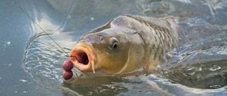
Fishing report on the Pra River in August
One of my favorite fishing places is the Pra River. These places are very well described by Paustovsky in “Meshcherskaya Side”. From the dacha it is most convenient for me to get to the village of Grishino or the village of Tyurvishchi. There are always a lot of people in Tyurvishchi on any day - the Moscow-Kasimov highway is nearby, and the shore is very swampy. But in Grishino, fishermen don’t sit on each other’s heads; you can walk along the shore, choose a place to your liking on the main channel, or go to the oxbow lake.
At the end of August, I don’t really like fishing on the Pre, because if the summer is dry, the water goes away, and the fish hide in the holes, and the gear clings to the snags, but then the children came to visit and gave them an entertainment program.