Determination (study) of the relief and structure of the bottom. Marker equipment
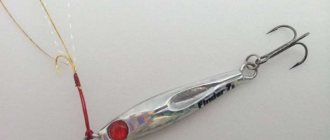
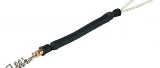
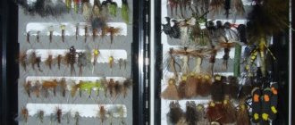
For this, there is so-called marker equipment, which you can make yourself. We will need: a special marker weight (with protrusions or spikes), a metal leash, a passage ring on one leg with a ceramic insert, a carabiner, a swivel, a bottle cap and a special marker float (photo 2).
You can do without a metal leash, a cork and a ceramic ring, but a metal leash will protect the load from being cut off on the shell rock, the cork will protect the ring from getting stuck in algae and will help it float, and in a ceramic ring the fishing line with a marker float glides better.
Today, there are three main ways to study the topography and structure of the bottom (jigging, pulling or dragging and measuring the depth with a marker float), as well as their combinations.
Jig (step) wiring
The simplest thing possible. You just need to know how to do jig wiring. How to do it is described in detail in Sergei Ripka’s article “Jig for Beginners.” We will only add that in our case the main requirement for wiring is the same amplitude and tempo of wiring. After each jerk, before the load falls to the bottom, you must count as quickly as possible, like using a machine gun. The difference in the score on adjacent jerks will allow you to detect differences in depth and imagine the relief of the reservoir.
If the score increases, then the depth also increases and vice versa. If the count is constant, then the bottom is level. This way we will find edges, holes, ledges and other features of the bottom topography. In Fig. Figure 2 in red shows the approximate trajectory of the load during jigging.
The numbers indicate the score for each jerk. The numbers, of course, are arbitrary and depend on the amplitude of the wiring and how quickly we count. It is clear that the smaller the amplitude, the more accurate the picture of the bottom relief. With this method, a float is not needed; the line is tied to the leash ring. The disadvantage of this method is that it does not provide information about the structure of the bottom.
Drawing or broaching
Keeping the end of the rod as low as possible, we pull the load along the bottom with the rod. Then we move the rod forward, reel in the line and pull it through again. At the same time, by the behavior of the quivertype and by the return to the hand, we determine which bottom the load is dragging along.
If the quivertype trembles, and we hear a ringing knock with our hand, the load goes over the pebbles; if we hear a dull shaking with our hand, it goes over shells; if the load goes easily, it’s sand; easily and sometimes even a slack is formed - down the slope. And so on.
When drawing, only the cord is used. At the same time, the faster the action of the rod, the better the bottom structure is recognized. Athletes use special ultra-fast marker rods for this. However, an experienced fisherman will make do with any fishing rod. Except that it will take a little more time.
This method in itself is completely self-sufficient and provides all the necessary information. Its disadvantage is that it is sometimes difficult to recognize some relief elements. For example, determining the relative heights of slopes of different steepness or distinguishing a gentle slope from a clayey area is not easy.
To master this method, you can spend some time training on the coastal shallows, where the topography and structure of the bottom are clearly visible. This way you can quickly understand, not in words, but in deeds, how the marker load behaves under different conditions. Suitable areas for training can also be found on the shore itself.
Combination of jig and pull
I think this method is the most universal. Since on flat areas we are interested in the structure of the bottom, and on slopes – their steepness and length, in the first case we give preference to pulling, and in the second – to jig.
In practice, it looks something like this: pull – jerk – pull – jerk. During the pull we determine the structure of the bottom, and during the jerk we keep score. Since on slopes we are not interested in the structure of the bottom, but only in the steepness and length of the slope, then, having discovered the slope, we only make jerks until the end of the slope.
The relative steepness of the slope is determined by the count, and its relative length is determined by the number of jerks. Then jerks and pulls alternate again. The disadvantage of this method is that you have to move the rod back and forth - when pulling, it is advisable to hold the rod lower, and when jerking, higher.
Marker float
In this case, the line is passed through the ring and tied to the float. When casting, just before the rig falls into the water, the rod makes a slight jerk upward. This will create additional friction on the rings, slow down the load and make it possible for the float to free itself from possible entanglement with the fishing line during flight. After the load falls to the bottom, the float is pulled towards the load.
Then, by hand releasing the line from the reel to the mark on the rod (if we have a marker rod) or to the first ring, we count how many times we released before the float surfaces. Knowing the distance to the mark or to the first ring, we determine the depth. You can do the opposite - let the float float up, and then, winding the line until the float stops with the load, count the revolutions of the reel. Knowing the characteristics of the coil, we determine the depth. Then, we drag the load along the bottom for a couple of meters, determining the structure of the bottom, and measure the depth again.
This method is the most accurate and is widely used by matchmakers. For a feeder, its main drawback is that it is not suitable for more or less serious currents, since the float, when ascending, is carried away and floats downstream horizontally, with the keel towards the load. As a result, it is almost impossible to detect. And when pulled up, the float immediately goes under the water.
Note also that for a feeder (unlike, say, a match), exact knowledge of the depth is not necessary. It is much more important to know the structure of the bottom and its relief.
What is an edge, a roll, a fall, watering, a navel CLEARLY
Today I propose to talk about our fishing terminology (river and lake), which includes such specific terms as edges, drops, tables, navels, which may seem incomprehensible to beginners in fishing.
And let's start with the most ambiguous and complex term - brow. The main difficulty is that it means different things in different cases.
The figure shows a certain slope in the relief: there was one depth, then a slope, and the depth went lower. In Russian, the noun “brovka” comes from the word brow and has many different interpretations in fishing literature, forums and documentaries about fishing.
Most often, an edge means a joint between two planes: straight or inclined. The joint at the top is called the top edge, the joint at the bottom is called the bottom edge. Between them there is a dump.
The edges are relatively compact, that is, if the dump stretches over 50 meters, then it cannot be called an edge. The most promising place for fishing with a feeder is most often the lower edge.
Let's move on to the next term. If we look at the edge from above, we will see that no one drew it in a straight line, with rare exceptions concerning artificial reservoirs. In natural reservoirs it is always rugged and broken.
Local protrusions towards the river bed (depth) are called tongues, and depressions towards the shore are called pockets. Such irregularities and anomalies in the topography of the edge are naturally very good points for searching and subsequent fishing.
The riverbed is where the river flows during the non-flood period, from bank to bank. Although some fishermen sometimes narrow this matter down to the point where the deepest section of the river is located (usually the ship's passage passes through).
Let's look at the channel in cross-section.
Irrigation is a large, extended section of the bottom of a reservoir, which smoothly rises from the edge either to the shore or to the next edge.
Steps are a characteristic relief similar to a staircase. The width of the steps is small, that is, more than 10 meters is no longer a step. Theoretically, each step can work and guarantee an excellent bite. Although it all depends on many factors, including shells, season, etc.
What is a table? Often used in relation to winter fishing as “fished on a riverbed table.” The table is actually watering, but more even. On reservoirs there are gigantic spaces where the depth changes by just 10-15 cm.
The figure shows a typical cross-section of the reservoir. There is a flooded river that used to flow there. To the left and right you can see wide, huge tables - flat areas where fish feed.
And if we're talking about reservoirs. There is such an anomaly in the bottom relief - the navel. Logically, it should be something concave, but in reality everything is exactly the opposite. The navel is a bulge at the bottom of the reservoir.
To understand what a belly button looks like, you need to imagine a man with a huge beer belly, who was laid on the bottom on his back. Over time, the man was covered with bottom sediments on all sides, leaving only a round mamon sticking out in all directions. This is a perfect example of a belly button. A very good place, fish always stay there.
A channel ditch is the deepest place in a river bed. There is also the concept of bank ditches, or they are otherwise called pre-channel ditches. They can be of artificial origin (for example, worked by a dredge) or natural.
To understand what type of channel ditches we are dealing with, it is recommended to walk along a section of the river with an echo sounder and try using a feeder from left to right. Typically, rivers up to 100 meters wide have one or maximum two ditches.
There is also the so-called entrance and exit from the pit. If we follow the flow of the river, then first there will be an entrance to the hole, and then, accordingly, an exit.
A riffle is a transverse shallow in a channel, a kind of rampart. It can go strictly across or at some angle. You don’t need to be a physicist to look at this picture and understand that the speed of the current increases sharply at the riffle.
What kind of fish can you catch on the edges?
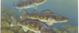
You can find any fish on the edge. But the edges become especially attractive for those peaceful fish that feed near the bottom or from the bottom. Among the carp fish, the most likely trophies may be bream, silver bream, bluefish, white-eye, carp, crucian carp and some others. Predators include pike and pike perch. Moreover, quite large specimens of fish are often found on the lower edge, because food competition has not been canceled.
Predatory fish not only set up ambushes on uneven bottom topography, but often patrol along the edges, catching unwary fish. At the same time, the victim can be either fry, who inadvertently swam to the upper edge from the shore, or edible, grown-up individuals who swam to the lower edge.
What is an eyebrow? How to find her? The meaning of the edge when fishing
The brow, in a simple layman's understanding for most fishermen, is a kind of step on the bottom topography of a reservoir. However, this is not quite true. In fact, on this step there are two edges, which are boundaries or lines separating the horizontal and inclined planes of the dump. Accordingly, a distinction is made between the upper and lower edges.
Usually, when they say that the fishing took place on the edge, it means the lower edge. And this is logical, because the concentration of fish is mainly observed at the bottom of the dump.
Types of edges
As a rule, a distinction is made between bank and channel edges:
- Coastal edges. They are found in all types of reservoirs, except for some small and silted ones, where the very concept of “edge” is absent. Sometimes there are several such edges due to the multi-stage nature of the bottom relief. Coastal edges are especially important for those fishermen who practice fishing with feeder gear or any other method of bottom fishing. In addition, they are coveted by spinning anglers who prefer fishing from the shore.
- Channel edges. Characteristic of reservoirs and large rivers. They are distinguished by their great length. On reservoirs, such edges are located in the beds of the rivers that formed the reservoir and are often located far from the shore. On rivers, channel edges are also located closer to the middle, but sometimes they can be located close to the bank on a concave (outer) bend of the river. Fishing on channel edges is especially popular in winter. During this period, in addition to general accessibility, such places are characterized by a large concentration of fish. In summer, fishing on channel edges is in most cases only possible from a boat.
Why should you fish on the edge?
Any unevenness of the bottom should be the object of close attention of the fisherman. After all, the upper and lower lines of these irregularities are, in fact, the edges. The edge is a place where fish gather and feed intensively. In addition, it serves as a shelter for both predatory and peaceful fish. On rivers with a fairly fast flow, the lower edge also becomes a resting place, where the flow speed is noticeably lower.
At the bottom of the dump, food always accumulates, which is brought by currents, both river and surf or coastal break. Therefore, when moving through a body of water, fish always stop in such places.