One of the most exciting experiences for thrill-seekers is riding a roller coaster. Their sharp turns can shake the soul out of the body and give the brightest emotions. But there are even cooler attractions in the world, for example, a bridge in Japan with the eloquent nickname “Trail of Death”. Many tourists who have seen it with their own eyes say that it looks like a giant roller coaster, only the rides on it are not special carriages, but ordinary cars.
Special design
Of course, the bridge was not built to scare tourists. The structure above the sea, connecting the cities of Sakaiminato and Matsue, was strongly curved so that large ships could easily pass under it. In St. Petersburg, for example, bridges are raised for this purpose, which is done at night. And the Eshima Ohashima Bridge is also a busy highway. There are a lot of ships sailing under the structure every day, making them wait until night is unprofitable. But blocking the traffic flow every time is inconvenient. So the architects had to get out differently.
As a result, a bridge with a length of 1.7 km and a width of 11 m was erected, which is the largest concrete structure in Japan and ranks third in the world ranking for this indicator. It has a two-lane highway connecting the two cities. The angle of inclination of the structure is actually not that large - 5-6%. And yet, the bridge was nicknamed the “Highway of Death” because it is scary to look at from the outside.
Cable-stayed bridges in Japan
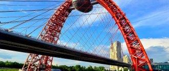
Cable-stayed bridge Tatara bridge
The cable-stayed Tatara bridge, with a span of 890 m and a pylon height of 220 m, connects the islands of Ikuchi (territory of the city of Onomichi) in the east and the island of Omishima (territory of the city of Imabari) in the west of Japan.
Cable-stayed bridge Tatara bridge
Parameters of the cable-stayed Tatara bridge
| No. | Main technical parameters of a cable-stayed bridge |
| 1 | Bridge layout: 270+890+320 m |
| 2 | The total length of the bridge is 1480 m |
| 4 | The length of the central channel span is 890 m |
| 5 | Bridge crossing width - 30.6 m |
| 6 | Underbridge clearance (clearance) - 26 m |
| 7 | Passage width - 5 m |
| 8 | Number of lanes – 4 (2 in each direction) |
| 9 | The height of the pylons is 220 m |
| 10 | Number of pylons - 2 pcs. |
| 11 | Start of construction - 1993 |
| 12 | Opening of the bridge crossing - May 1, 1999 |
| 13 | Construction cost: $605.8 million. |
| 14 | Location — 34°15′34.1″N 133°3′41.5″E |
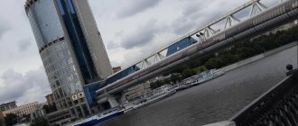
Cable-stayed bridge Tsurumi Tsubasa Bridge
Cable-stayed bridge (Tsurumi Tsubasa Bridge) is a cable-stayed road bridge with a span of 510 m and a total length of 1021 m, built in Kanagawa (Japan). Kanagawa is a prefecture located in the Kanto region on the island of Honshu, Japan. and opened in Tokyo (Japan) on December 21, 1994. The steel consumption for the bridge was 39,160 tons. The material of the pylon and span was steel.
Cable-stayed bridge Tsurumi Tsubasa Bridge
The width of the Tsurumi Tsubasa Bridge span is 38 m
Parameters of the Tsurumi Tsubasa Bridge cable-stayed bridge
| No. | Main technical parameters of a cable-stayed bridge/characteristics bridge |
| 1 | Total length of the cable-stayed bridge (total length) - 1020 m |
| 2 | Cable-stayed bridge width (width/deck width) — 38 m |
| 3 | Design span of the bridge (main span/longest span) - 510 m |
| 4 | Pylon height (hight pylons) - 183 m |
| 5 | Opening of the bridge (opened) - December 21, 1994 |
| 6 | Location/Coordinates — Kanagawa prefecture in Japan — 35° 28′ 19.14″ N 139° 41′ 57″ E |
Cable-stayed bridge Katsushika Harp Bridge
Cable-stayed bridge (Katsushika Harp Bridge) is a cable-stayed road bridge with a span of 220 m and a total length of 455 m, built and opened in Tokyo (Japan) on September 9, 1987. The steel consumption for the bridge was 7100 tons. Material of the pylon and span structure - steel
Katsushika Harp Bridge with a span of 220 m
Top view of the cable-stayed Katsushika Harp Bridge
Parameters of the Katsushika Harp Bridge
| No. | Main technical parameters of a cable-stayed bridge/characteristics bridge |
| 1 | Total length of the cable-stayed bridge (total length) - 455 m |
| 2 | Cable-stayed bridge width (width/deck width) — 23.5 m |
| 3 | Design span of the bridge (main span/longest span) - 220 m |
| 4 | Pylon height (hight pylons) - 65 m and 29 m |
| 5 | Opening of the bridge (opened) - September 9, 1987 |
| 6 | Location/Coordinates - Tokyo, Tokyo, Japan - 35° 43′ 21.47″ N 139° 50′ 32.97″ E |
Yokohama Bay Bridge
The Yokohama Bay Bridge is a cable-stayed road bridge with a span of 460 m and a length of 860 m, built in Yokohama, Japan. Bridge diagram 200+460+200. The height of the span is 13.75m.
Yokohama Bay Bridge 860 m long
Parameters of the Yokohama Bay Bridge
| No. | Main technical parameters of a cable-stayed bridge/characteristics bridge |
| 1 | Total length of the cable-stayed bridge (total length) - 860 m |
| 2 | Cable-stayed bridge width (width/deck width) — 40.2 m |
| 3 | Design span of the bridge (main span/longest span) - 460 m |
| 4 | Pylon height (hight pylons) - 172 m |
| 5 | Clearance below - 55 m |
| 6 | Construction start - November 1980 |
| 7 | Opening of the bridge (opened) - September 27, 1989 |
| 8 | Number of lanes - 6 |
| 9 | Location/Coordinates – Yokohama, Japan – 35°27′18″N 139°40′27″E |
Illusion of deception
Those who have seen pictures of the bridge are sure that it received its bad nickname because accidents often occur on it due to its sharp bend. In fact, accidents occur here no more often than usual. Rumors about the danger of Eshima Ohashima have been greatly exaggerated. And in general, the frightening steepness of the bridge itself is nothing more than a clever illusion. The building looks dangerous only from certain angles.
This feature of the bridge was first used by the automobile company Daihatsu Motor, which filmed its advertising video on it. In it, the car successfully overcomes the “death route”, which shows its reliability and toughness. The trend was picked up by photographers and bloggers, who deliberately began photographing the landmark from unfavorable angles and posting eerie pictures online. The Eshima Ohashima Bridge became famous, became a popular attraction and attracted a large number of tourists.
Seto Bridge
- Address:
Japan, 711-0925 Okayama Prefecture, Kurashiki - Telephone:
+81 86-426-3030 - Website:
kurashiki-tabi.jp - Opening date:
April 10, 1988 - Bridge length:
37 km - Fare:
3500 yen ($30.3)
The Seto Bridge is the greatest building of modern times, which has become a national treasure of Japan, its pride and confirmation of the highest level of development of its technology and industry.
Location
The Seto-Ohashi Bridge is an overpass in the Inland Sea of Japan that connects the cities of Kurashiki on the island of Honshu and Sakaide on the island of Shikoku, as well as the islands of Hokkaido and Hondo.
The history of the Seto Bridge
At the end of the 19th century, the first steam locomotive line appeared on the island of Shikoku, and with it the idea was born of the need to connect the island with the rest of Japan to facilitate transport communications and increase trade turnover. Construction of the bridge began in 1978 and lasted for 10 years. 50 thousand people were involved in the project. The implementation of the project required 1,130 billion Japanese yen (about $9 billion).
Small islands in the Inland Sea of Japan were used to construct the Great Seto Bridge. During construction, the increased seismic activity of Japan was taken into account (the Seto Bridge can withstand an earthquake of up to 8 points on the Richter scale) and the likelihood of tides (merchant ships will be able to pass under the bridge in this case, since its minimum height above the water will be at least 65 m) . The bridge began operating in April 1988, and today it is a symbol of the country's technical and economic progress.
What is interesting about the Seto Bridge?
Seto-Ohashi is a two-tier transportation complex that includes the four-lane Seto-Chuuoo Expressway and the Seto-Ohashi Shinkansen high-speed rail line located underneath it. There are 30 bus stops along the highway, travel on it is paid, the price is the same in both directions. As for the Honsi-Bissa railway line, it includes 3 stations: Kaminoho, Kojima and Kimi. Of particular interest is the section of the highway and railway line located in a special tunnel under water.
The Seto Bridge stretches from north to south in the form of a chain of 6 separate bridges, of which 3 are suspension bridges, 2 are cable-stayed and 1 is with through trusses. All bridges have separate names, and from north to south their sequence looks like this:
- Shimotsui-Seto
is a 1.4 km long suspension bridge on two supports with a longest span of 940 m. It connects the islands of Honshu and Hitsuishi; - Hitsuishijima
is a cable-stayed double-support bridge 790 m long with a maximum span of 420 m. It connected the islands of Hitsuishi and Iwakuro; - Iwakurojima
- similar in characteristics to the previous bridge. Links the islands of Iwakuro and Wasa; - Yoshima
is a five-span overpass with through trusses, fixed on two supports. The length of the Yoshima Bridge is 847 m, and the largest span is 246 m. It serves as a connecting link between the islands of Vasa and Yo; - Kita (North) Bisan Seto
is the second longest of all the bridges in the Seto chain and the 33rd in the world (1538 m). This is a double-support suspension bridge connecting Yo Island and the following Minami Bisan-Seto Bridge; - Minami (South) Bisan-Seto
is the longest among all the Seto-Ohashi bridges (1648 m), ranking 22nd in the world in terms of length. This two-legged suspension bridge connects Kita Bisan-Seto to Shikoku Island. The road surface at Minami Bisan-Seto is located at an altitude of 93 m.
How to get there?
To see the Seto Bridge, you can travel from Tokyo or Osaka. From the capital of Japan, you can travel by plane from Haneda Airport to Okayama Airport (flight time is 1 hour 15 minutes) or by train to Okayama (route takes 3 hours 20 minutes) and then another half hour on the JR Seto-Ohashi Line to the Kojima stop. From Osaka to the Seto Bridge it takes only 50 minutes by Shinkansen from Shin-Osaka Station to Okayama Station. You can appreciate all the beauty and grandeur of the bridge by driving across it by car or high-speed train, or by taking an excursion on a ferry that travels between the islands.
Scariest bridges in the world
The Japanese “Highway of Death,” of course, is unique in its kind, but there are other bridges in the world that are scary to even approach, let alone cross. In Russia, however, there are no such structures, but many tourists admit that they experienced sensations comparable to riding a roller coaster while driving along the serpentine road to Ai-Petri in Crimea. The angle of dangerous turns (there are 280 of them) here is 180 degrees, and the total steepness of the climb is 10%.
In China there is a bridge spanning the Xiduhe River at an altitude of 490 meters. It is the tallest in the world.
In the American state of Colorado, especially for tourists who love thrills, a bridge was thrown across a mountain gorge at an altitude of 291 meters. Travelers have to overcome a frightening path 380 meters long. In France there is the Millau Viaduct, 314 meters high.
Akashi-Kaikyo Bridge
general information
The total length of the bridge is 3911 meters, and the distance between the supports is 1991 meters. Due to its size, the bridge was twice included in the Guinness Book of Records. The bridge design has its own special technical features of the bridge, designed to ensure that the bridge can withstand extreme loads. This is a system of double-hinged stiffening beams that allow the bridge to withstand wind speeds of up to 80 meters per second, resist sea currents and withstand earthquakes of magnitude up to 8.5. Special pendulum systems are also used that operate at the resonant frequency of the bridge structure. About 500 billion yen were spent on construction. The bridge connected two large islands of Japan - Honshu and Shikoku. If you want to admire the views from the bridge and the bridge itself, then from the Kobe side there is a 317-meter long concrete promenade specially built for this purpose.
History of construction
The decision to build the bridge was made by the Japanese government back in the late 50s. It was forced to listen to the views of local residents who went on strike after the death of 168 children on two ferries that sank during the storm. However, the matter moved from a dead point only in 1988.
During the construction of Akashi-Kaikyo, the greatest difficulties were created by the sea itself with its salt water, strong currents and soft soil. To prevent the destruction of underwater bridge structures under the influence of sea water, the Japanese invented especially strong, quickly hardening concrete and built a plant for its production near the construction site. This concrete was used to create two huge round platforms, which were poured on the shore and then sunk with incredible precision for their size (the error was only 10 cm). They served as the basis for the pylons, the construction of which became the next stage of construction. Having withstood the 7.3 magnitude earthquake of 1995, the tallest pylons in the world at that time successfully passed the strength test.
The Akashi-Kaikyo Bridge opened on April 5, 1998, providing an alternative to the unsafe ferry crossing.
Interesting Facts
- If you tie all the cables of the Akashi-Kaikyo Bridge into one line, then they can encircle the globe 7 times!
- Since the construction of the Akashi-Kaikyo Bridge cost the Japanese government almost $5 billion, travel on it is paid - the cost is $20. Therefore, today those who want to save money risk their lives and continue to use the ferry crossing.
- The bridge has an unofficial name - Pearl Bridge.