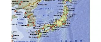
Administrative divisions of Japan
The structure of the state harmoniously combines traditions and innovations. The system of traditional ideas of Shintoism and Buddhism has led to the fact that in the Land of the Rising Sun great importance is attached to hierarchy. Any solution goes through certain levels, each of which complements and enriches it. Japan is characterized by both subordination to one's elders - in terms of status and age - and respect for a person's sovereign opinion and personal space. This became the basis for the allocation of territorial units in the country. At the end of the 19th century, administrative reforms took place in the country, which preserved the old form, but introduced improvements to it. This is how the prefectures of Japan, or todofuken, came into being. At first there were about 300, then there was a reduction to 72, and in 1888 their current number was determined - 47. In turn, prefectures can be divided into counties and districts. They are also part of larger regions; there are only 8 of them in Japan. Today, the rapid growth of some cities again raises the need to reform the territorial division of the country, but they are still in the draft.
Types of prefectures
Historically, the country has developed four types of territorial management:
- That. The Tokyo metropolitan area is designated as a separate administrative unit;
- ken. These are the prefectures themselves, which provide for a greater degree of autonomy from the central government; there are 43 of them in the country;
- before. This is a special territory with its own rights and characteristics - Hokkaido;
- ugh. These are two cities that have the status of a separate district: Kyoto and Osaka.
In turn, smaller parts are distinguished within these large territories. Each administrative unit is headed by its own governor; he has fairly broad rights to govern his part of the country. The prefectures of Japan are in close cooperation with the center, but are not subordinate to it in everything. Moreover, all positions of local government, including its head, are elected. The goal of territorial policy is to prevent conflict situations.
Full list
Eight large regions unite all the prefectures of Japan. The list of administrative units is as follows:
— Hokkaido is a special prefecture divided into 14 districts;
— the Kyushu region includes the prefectures: Miyazaki, Okinawa, Nagasaki, Kumamoto, Kagoshima, Saga, Oita, Fukuoka;
— Tohoku unites Fukushima, Aomori, Miyagi, Akita, Yamagata, Iwate;
— Shikoku includes the prefectures of Tokushima, Kagawa, Kochi, Ehime;
— the Kanto region consists of the prefectures of Chiba, Tochigi, Saitama, Ibaraki, Gunma, Tokyo;
— Chugoku unites Yamaguchi, Shimane, Tottori, Okayama, Hiroshima;
— the Kinki region consists of the prefectures of Wakayama, Hyogo, Mie, Nara, Kyoto, Osaka, Shiga;
- Chubu includes the territorial units of Yamanashi, Gifu, Nagano, Ishikawa, Niigata, Toyama, Fukui, Shizuoka, Aichi.
Lists of prefectures
Prefectures of Japan with colored regions
Various frame parsing systems are ways in which Japanese prefectures are perceived:
Japanese ISO
Prefectures are also often divided into eight regions ( Chih
). These regions are not formally defined, have no elected officials, and are not legal entities. But the practice of ordering prefectures based on their geographic region is traditional. This order is reflected in the Japanese International Organization for Standardization (ISO) encoding. From north to south (numbering in ISO 3166-2: order) the prefectures of Japan and their commonly associated regions are:
| Hokkaido | Tohoku | Kanto | Tube | Kansai | Chugoku | Shikoku | Kyushu |
| 1. Hokkaido | 2. Aomori 3. Iwate 4. Miyagi 5. Akita 6. Yamagata 7. Fukushima | 8. Ibaraki 9. Tochigi 10. Gunma 11. Saitama 12. Chiba 13. Tokyo 14. Kanagawa | 15. Niigata 16. Toyama 17. Ishikawa 18. Fukui 19. Yamanashi 20. Nagano 21. Gifu 22. Shizuoka 23. Aichi. | 24. Mie 25. Shiga 26. Kyoto 27. Osaka 28. Hyogo 29. Nara 30. Wakayama | 31. Tottori 32. Shimane 33. Okayama 34. Hiroshima 35. Yamaguchi. | 36. Tokushima 37. Kagawa 38. Ehime 39. Kochi | 40. Fukuoka 41. Saga 42. Nagasaki 43. Kumamoto 44. Oita 45. Miyazaki 46. Kagoshima 47. Okinawa |
By English name
The default alphabetical order in this sortable table can be changed to reflect traditional Japanese regions and ISO analysis.
| Prefecture | Capital | Region | Major Island | Population¹ | Area² | Density ³ | Distr. | Municipalities | ISO | Area code | ||
| Aichi | 愛知県 | Nagoya | 名古屋市 | Tube | Honshu | 7 484 094 | 5 172,48 | 1,446,9 | 7 | 54 | JP-23 | 052 |
| Akita | 秋田県 | Akita | 秋田市 | Tohoku | Honshu | 1 022 839 | 11 637,54 | 87,9 | 6 | 25 | JP-05 | 018 |
| Aomori | 青森県 | Aomori | 青森市 | Tohoku | Honshu | 1 308 649 | 9 645,59 | 135,7 | 8 | 40 | JP-02 | 017 |
| Chiba | 千葉県 | Chiba | 千葉市 | Kanto | Honshu | 6 224 027 | 5 157,65 | 1 206,8 | 6 | 54 | JP-12 | 043 |
| Ehime | 愛媛県 | Matsuyama | 松山市 | Shikoku | Shikoku | 1,385,840 | 5 676,11 | 244,2 | 7 | 20 | JP-38 | 089 |
| Fukui | 福井県 | Fukui | 福井市 | Tube | Honshu | 787 099 | 4 190,49 | 187,8 | 7 | 17 | JP-18 | 077 |
| Fukuoka | 福岡県 | Fukuoka | 福岡市 | Kyushu | Kyushu | 5 102 871 | 4 986,40 | 1 023,4 | 12 | 60 | JP-40 | 092 |
| Fukushima | 福島県 | Fukushima | 福島市 | Tohoku | Honshu | 1 913 606 | 13 783,74 | 138,8 | 13 | 59 | JP-07 | 024 |
| Gifu | 岐阜県 | Gifu | 岐阜市 | Tube | Honshu | 2,032,533 | 10 621,29 | 191,4 | 9 | 42 | JP-21 | 058 |
| Gunma | 群馬県 | Maebashi | 前橋市 | Kanto | Honshu | 1 973 476 | 6 362,28 | 310,2 | 7 | 35 year | JP-10 | 027 |
| Hiroshima | 広島県 | Hiroshima | 広島市 | Chugoku | Honshu | 2 844 963 | 8 479,45 | 335,5 | 5 | 23 | JP-34 | 082 |
| Hokkaido | 北海道 | Sapporo | 札幌市 | Hokkaido | Hokkaido | 5,383,579 | 83 424,31 | 68,6 | 66 | 180 | JP-01 | 011–016 |
| Hyogo | 兵庫県 | Kōbe | 神戸市 | Kansai | Honshu | 5 536 989 | 8 400,96 | 659,1 | 8 | 41 years old | JP-28 | 073 |
| Ibaraki | 茨城県 | Mito | 水戸市 | Kanto | Honshu | 2 917 857 | 6 097,06 | 478,6 | 7 | 44 | JP-08 | 029 |
| Ishikawa | 石川県 | Kanazawa | 金沢市 | Tube | Honshu | 1,154,343 | 4 186,09 | 275,8 | 5 | 19 | JP-17 | 076 |
| Iwate | 岩手県 | Morioka | 盛岡市 | Tohoku | Honshu | 1 279 814 | 15 278,40 | 83,8 | 10 | 33 | JP-03 | 019 |
| Kagawa | 香川県 | Takamatsu | 高松市 | Shikoku | Shikoku | 976 756 | 1876,72 | 520,5 | 5 | 17 | JP-37 | 087 |
| Kagoshima | 鹿児島県 | Kagoshima | 鹿児島市 | Kyushu | Kyushu | 1 648 752 | 9 186,94 | 179,4 | 8 | 43 years old | JP-46 | 099 |
| Kanagawa | 神奈川県 | Yokohama | 横浜市 | Kanto | Honshu | 9 127 323 | 2 415,83 | 3778,2 | 6 | 33 | JP-14 | 045 |
| Kochi | 高知県 | Kochi Kochi | 高知市 | Shikoku | Shikoku | 728 461 | 7 103,93 | 102,5 | 6 | 34 | JP-39 | 088 |
| Kumamoto | 熊本県 | Kumamoto | 熊本市 | Kyushu | Kyushu | 1,786,969 | 7 409,35 | 241,2 | 9 | 45 | JP-43 | 096 |
| Kyoto | 京都府 | Kyoto | 京都市 | Kansai | Honshu | 2 610 140 | 4 612,19 | 565,9 | 6 | 26 | JP-26 | 074 |
| Mie | 三重県 | 津市 | Kansai | Honshu | 1,815,827 | 5 774,40 | 314,5 | 7 | 29 | JP-24 | 059 | |
| Miyagi | 宮城県 | Sendai | 仙台市 | Tohoku | Honshu | 2,334,215 | 7 282,22 | 320,5 | 10 | 35 year | JP-04 | 022 |
| Miyazaki | 宮崎県 | Miyazaki | 宮崎市 | Kyushu | Kyushu | 1 104 377 | 7 735,31 | 142,8 | 6 | 26 | JP-45 | 098 |
| Nagano | 長野県 | Nagano | 長野市 | Tube | Honshu | 2 099 759 | 13 104,29 | 154,8 | 14 | 77 | JP-20 | 026 |
| Nagasaki | 長崎県 | Nagasaki | 長崎市 | Kyushu | Kyushu | 1 377 780 | 4 132,09 | 333,4 | 4 | 21 years old | JP-42 | 095 |
| Nara | 奈良県 | Nara | 奈良市 | Kansai | Honshu | 1,365,008 | 3 691,09 | 369,8 | 7 | 39 | JP-29 | 074 |
| Niigata | 新潟県 | Niigata | 新潟市 | Tube | Honshu | 2 305 098 | 12 584,10 | 183,2 | 9 | 30 | JP-15 | 025 |
| Ōita | 大分県 | Oita Ōita | 大分市 | Kyushu | Kyushu | 1,166,729 | 6 340,71 | 184 | 3 | 18 | JP-44 | 097 |
| Okayama | 岡山県 | Okayama | 岡山市 | Chugoku | Honshu | 1 922 181 | 7 114,50 | 270,2 | 10 | 27 | JP-33 | 086 |
| Okinawa | 沖縄県 | Naha | 那覇市 | Kyushu | Ryukyu Islands | 1,434,138 | 2 281,12 | 628,7 | 5 | 41 years old | JP-47 | 098 |
| Osaka | 大阪府 | Saka | 大阪市 | Kansai | Honshu | 8 838 908 | 1 905,14 | 4 639,9 | 5 | 43 years old | JP-27 | 06x |
| Saga | 佐賀県 | Saga | 佐賀市 | Kyushu | Kyushu | 833 245 | 2440,68 | 341,4 | 6 | 20 | JP-41 | 095 |
| Saitama | 埼玉県 | Saitama | さいたま市 | Kanto | Honshu | 7 261 271 | 3797,75 | 1 912 | 8 | 63 | JP-11 | 048 |
| Shiga | 滋賀県 | Otsu | 大津市 | Kansai | Honshu | 1,413,184 | 4 017,38 | 351,8 | 3 | 19 | JP-25 | 077 |
| Shimane | 島根県 | Matsue | 松江市 | Chugoku | Honshu | 694 188 | 6 708,24 | 103,5 | 5 | 19 | JP-32 | 085 |
| Shizuoka | 静岡県 | Shizuoka | 静岡市 | Tube | Honshu | 3 701 181 | 7 777,42 | 475,8 | 5 | 35 year | JP-22 | 054 |
| Tochigi | 栃木県 | Utsunomiya | 宇都宮市 | Kanto | Honshu | 1 974 671 | 6 408,09 | 308,2 | 5 | 26 | JP-09 | 028 |
| Tokushima | 徳島県 | Tokushima | 徳島市 | Shikoku | Shikoku | 756 063 | 4 146,65 | 182,3 | 8 | 24 | JP-36 | 088 |
| Tokyo | 東京都 | Shinjuku | 新宿区 | Kanto | Honshu | 13 513 734 | 2 190,93 | 6 168,1 | 1 | 39 | JP-13 | 03x042 |
| Tottori | 鳥取県 | Tottori | 鳥取市 | Chugoku | Honshu | 573 648 | 3 507,05 | 163,6 | 5 | 19 | JP-31 | 085 |
| Toyama | 富山県 | Toyama | 富山市 | Tube | Honshu | 1 066 883 | 4 247,61 | 251,2 | 2 | 15 | JP-16 | 076 |
| Wakayama | 和歌山県 | Wakayama | 和歌山市 | Kansai | Honshu | 963 850 | 4 724,69 | 204 | 6 | 30 | JP-30 | 075 |
| Yamagata | 山形県 | Yamagata | 山形市 | Tohoku | Honshu | 1,122,957 | 9 323,15 | 120,4 | 8 | 35 year | JP-06 | 023 |
| Yamaguchi | 山口県 | Yamaguchi | 山口市 | Chugoku | Honshu | 1 405 007 | 6 112,30 | 229,9 | 4 | 19 | JP-35 | 083 |
| Yamanashi | 山梨県 | Kōfu | 甲府市 | Tube | Honshu | 835 165 | 4 465,27 | 187 | 5 | 27 | JP-19 | 055 |
Notes: ¹ as of 2015; ² km²; ³ per km²
Territorial disputes
If you look at the Japanese version of the world map, you can see that it has a number of inconsistencies with maps created in other countries. This is due to the fact that Japan considers as its own some territories that officially belong to other states. Territorial disputes exist between the Land of the Rising Sun, China, Korea and Russia. Thus, part of the islands of the Kuril chain are, according to the Japanese, part of the Hokkaido Prefecture of Japan. The dispute arose as a result of the fact that following the Second World War in 1946, these islands became part of the Soviet Union. Before this, the Kuril Islands and Sakhalin were at times the property of Russia, and at times Japan. Historically, these lands were first inhabited by the Japanese.
Former prefectures
1870s
See the Japanese Wikipedia article for all the changes during that period. See also list of prefectures in Japan by population in English Wikipedia#Historical demographics of prefectures in Japan for lists of prefectures since the late 1860s.
1880s
| Prefecture | Japanese | Year of cancellation | Fate |
| Kanazawa | 金沢県 | 1869 | Renamed Ishikawa |
| Sendai | 仙台県 | 1871 | Renamed Miyagi |
| Morioka | 盛岡県 | 1872 | Renamed Iwate |
| Nagoya | 名古屋県 | 1872 | Renamed to Aichi |
| Nukata | 額田県 | 1872 | Merged with IT |
| Nanao | 七尾県 | 1872 | Merged with Ishikawa and Shinkawa |
| Iruma | 入間県 | 1873 | Merged into Kumagaya and Kanagawa |
| Inba | 印旛県 | 1873 | Merged with Chiba |
| Kisarazu | 木更津県 | 1873 | Merged with Chiba |
| Utsunomiya | 宇都宮県 | 1873 | Merged with Tochigi |
| Asuwa | 足羽県 | 1873 | Merged with Tsuruga |
| Kashiwazaki | 柏崎県 | 1873 | Merger with Niigata |
| Ichinoseki → Mizusawa → Iwai | 一関県→水沢県→磐井県 | 1875 | Merged with Iwate and Miyagi |
| Okitama | 置賜県 | 1875 | Merged with Yamagata |
| Niihari | 新治県 | 1875 | Merged with Ibaraki and Chiba |
| Sakata → Tsuruoka | 酒田県 → 鶴岡県 | 1876 | Merged with Yamagata |
| Taira → Iwasaki | 平県 → 磐前県 | 1876 | Merged with Fukushima and Miyagi |
| Wakamatsu | 若松県 | 1876 | Merged with Fukushima |
| Chikuma | 筑摩県 | 1876 | Merger with Nagano and Gifu |
| Tsuruga | 敦賀県 | 1876 | Merged with Ishikawa and Shiga |
| Niikawa | 新川県 | 1876 | Merged with Ishikawa |
| Sakai | 堺県 | 1881 | Merged with Osaka |
| Ashigara | 足柄県 | 1876 | Merged with Kanagawa and Shizuoka |
| Kumagaya | 熊谷県 | 1876 | Merged with Gunma and Saitama |
| Aikawa | 相川県 | 1876 | Merger with Niigata |
| Hamamatsu | 浜松県 | 1876 | Merged with Shizuoka |
| Hakodate | 函館県 | 1886 | Merger with Hokkaido |
| Sapporo | 札幌県 | 1886 | Merger with Hokkaido |
| Nemuro | 根室県 | 1886 | Merger with Hokkaido |
| Tokyo | 東京府 | 1943 | Reorganized into Tokyo Metropolis (東京都) |
Lost after World War II
Here are some territories that were lost after World War II. This does not include all territories of the Japanese Empire, such as Manchukuo.
| Territory | Prefecture | Allied occupation | Current status | ||||
| Name | Japanese | Capital | A country | Name | Capital | ||
| Mainland | Okinawa | 沖縄県 | Naha | United States | Japan | Okinawa | Naha |
| Karafuto | 樺太庁 | Toyohara | Soviet Union | Russia | part of Sakhalin | Yuzhno-Sakhalinsk | |
| Korea | Heian Hoku | 平安北道 | Shingishū | North Korea | North Pyongan | Sinuiju | |
| Heian-nan | 平安南道 | Heijou | South Pyongan | Pyongyang | |||
| Kankyo-hoku | 咸鏡北道 | Seishin | North Hamgyong | Ranam | |||
| Kankyo-nan | 咸鏡南道 | Kanko | South Hamgyong | Hamhung | |||
| Kokai | 黃海道 | Kaishu | Hwanghae | Haeju | |||
| Kōgen | 江原道 | Shunsen | Kangwon | Chuncheon | |||
| United States | South Korea | Gangwon | |||||
| Chusei-hoku | 忠清北道 | Seichu | North Chuncheon | Cheongju | |||
| Chusei-nan | 忠清南道 | Tayden | South Chuncheon | Daejeon | |||
| Keiki | 京畿道 | Keijo | Gyeonggi | Seoul | |||
| Keiso-hoku | 慶尚北道 | Taikyu | North Gyeongsang | Daegu | |||
| Keisho-nan | 慶尚南道 | Fuzan | South Gyeongsang | Busan | |||
| Zenra-hoku | 全羅北道 | Zenshu | North Jeolla | Jeonju | |||
| Zenra-nan | 全羅南道 | Koshu | South Jeolla | Gwangju | |||
| Taiwan | Hōko | 澎湖庁 | Mako | republic of china | Taiwan | Penghu | Magong |
| Karenko | 花蓮港庁 | Karenko | Hualien | Hualien | |||
| Shinchiku | 新竹州 | Shinchiku | Hsinchu | Hsinchu | |||
| Taichu | 台中州 | Taichu | Taichung | Taichung | |||
| Taihoku | 台北州 | Taihoku | Taipei | Taipei | |||
| Tainan | 台南州 | Tainan | Tainan | Tainan | |||
| Tait | 台東庁 | Tait | Taitung | Taitung | |||
| Takao | 高雄州 | Takao | Kaohsiung | Kaohsiung | |||
| Kanto | 関東州 | Dairen | Soviet Union | China | part of Dalian, Liaoning | ||
| Nanyo | 南洋庁 | Korra | United States | Palau | Ngerulmud | ||
| Marshall Islands | Majuro | ||||||
| Federated States of Micronesia | Palikir | ||||||
| United States | Northern Mariana Islands | Saipan | |||||
Prefectural flags
The prefectures of Japan emphasize their independence and uniqueness by having their own flag. Japanese culture attaches special importance to coats of arms and flags: they not only serve as a means of identifying a territory, but also convey a certain key message that describes the special characteristics of the region. Almost every village in the country has its own flag, not to mention the prefectures. The banners are decorated with pictograms with deep meaning; it is not always clear to a foreigner, but is well read by the residents of the country. Looking at the flags, you can see geometric and stylized images that are encrypted messages. For example, the city and prefecture of Aomori in Japan decorated its flag with a stylized symbol that is difficult for Europeans to read - the “crown of Honshu.” This is a simplified depiction of the outlines of the three parts that make up the land of the region. The background of the flag is white, which means the vastness of the prefecture, and the green color of the figure symbolizes hope for the development and prosperity of these lands. And Tottori Prefecture (Japan) decorated its flag with a white hiragana “to” sign, reminiscent of a white bird in flight. This image for the people of the region means freedom, development and peace of the prefecture.
Powers[edit]
Main article: Government of Japan § Local government
Japan is a unitary state. The central government delegates many functions (such as education and police) to prefectures and municipalities, but retains full control over them. Although local government spending accounts for 70 percent of total government spending, the central government controls local budgets, tax rates, and borrowing. [5]
The functions of the prefectural government include the organization of prefectural police, school supervision and maintenance of prefectural schools (mostly high schools), prefectural hospitals, prefectural roads, supervision of prefectural waterways, and regional urban planning. Their responsibilities include tasks delegated to them by the national government, such as maintaining most regular national roads (with the exception of certain major cities), and the prefectures coordinate and support their municipalities in their functions. De facto prefectures as well as municipalities were often less autonomous than the formal extent of local autonomy law suggests because
- most are heavily dependent on central government funding - a dependence that has recently been exacerbated in many regions by demographic transitions that are hitting rural areas harder/earlier as cities can partly offset this through rural migration, and
- In many policy areas, the basic framework is strictly established by national laws, and prefectures and municipalities are autonomous only within these frameworks.
Prefecture coins
Since 2008, the mint began producing “Japanese Prefecture” coins, which are also designed to highlight the uniqueness of each region. While not all prefectures have acquired their own coin, this program lasted for several years. But the issued banknotes impress with their beauty and thoughtfulness: the most important symbols of the territory are chosen for the image. For example, a coin from Shiga Prefecture features a drawing of the outline of Lake Biwa, the largest in Japan. Also on the reverse you can see an image of the little grebe bird, which lives on the lake. The coins of Okinawa, Miyazaki and Kanagawa prefectures depict warriors in typical attire for the region. The main architectural landmarks of the territory were chosen as the background for the human figures.
Special territory
Among all the regions of the country, Hokkaido Prefecture is the most different. Japan finally annexed this territory to its lands only in 1869 as a result of colonization. Before this time, very ancient settlements existed here. The Jomon culture began to take shape as early as the 6th millennium BC. It then transformed into the Satsumon culture, and in the 13th century AD it became the source for the emergence of the unique Ainu culture. This nation experienced constant Japanese encroachment on their lands; relations between the two cultures consisted of an alternation of wars and peaceful trade. But at the end of the 19th century, the island was finally colonized by the Japanese. But since those times, a special atmosphere has been preserved here, which is also supported by the special rights of this territorial unit. It is headed by a governor rather than a prefect, as in other states, Hokkaido has more autonomy and rights compared to other prefectures. The main city of the region is Sapporo. Hokkaido is the northernmost and largest prefecture of Japan. The country believes that part of the Kuril Islands should belong to this prefecture. The blue flag of Hokkaido Prefecture is decorated with a white seven-pointed star with red lines in the middle. In some ways this sign resembles a snowflake and symbolizes hope and development. For the Japanese, blue means the sea and sky of northern Hokkaido, white means light and snow, and red means the life-affirming energy of the people.
Other attractions
There are other attractions you can see on the Okinawa Islands in Japan. For example, the city of Chatan is a resort. It is very conveniently located for various tourist shops and catering establishments.
Also on the archipelago, it is worth visiting the large oceanarium Okinawa Churaumi, located in the park. It was built in 2002, its design is elegant, and the building looks like huge feet. There you can look not only at representatives of tropical, oceanic and underwater habitats. At the upper entrance, visitors will be able to see a beautiful view of coral reefs with unique species of fish. The lower you go, the more picturesque the view you will see.
The northern part of Okinawa is a mountainous region. In the center there are mountains with a height of 300 to 500 m. Residents call this area Yambaru. There you can see unique species of animals and plants.
A special place in southern Okinawa is Sefa Utaki, which is a sacred place and is mentioned in Ryukyuan legends. It was there that the monks were ordained, and the monarch personally visited this place twice a year to pray to the gods for a good harvest and hunting. This is a triangular grotto created by nature about 150,000 years ago as a result of an earthquake. Safa Utaki is part of the UNESCO World Heritage Site.