How the sea appeared in the Moscow region
The first thoughts about creating a canal connecting the Volga and Moscow Rivers appeared during the reign of Alexei Mikhailovich. His son Peter the Great considered the idea absurd and too expensive. Digging of the canal began only in 1825. The work was carried out for about 25 years, the canal operated for 10 years and then was abandoned for a long time. The issue was raised again at the beginning of the 20th century, when the need arose for an additional supply of drinking water to the capital. Construction of the canal was completed only in 1937. The very first flood completely filled the reservoir - the real Moscow Sea appeared.
Port of Five Seas
There is an expression “Moscow is a port of five seas.” However, looking at the map of Moscow, no seas are visible. To understand this expression, it is necessary to return to 1936, when the construction of the Moscow Canal was completed. The opening of the canal contributed to the influx of clean water from the Volga River, which was so necessary for the rapidly growing industrial city of Moscow. The opening of the canal influenced the launch of a number of similar projects for the construction of a network of other large water canals: the White Sea-Baltic, Volga-Baltic and Volga-Don. It turns out that being in the waters of the canal and the network of connected reservoirs, you can find yourself in the five seas of the Black, White, Baltic, Azov and Caspian at once.
Ivankovskoye Reservoir
Located in the European part of the country on the Volga River, it was formed by the dam of the Ivankovo hydroelectric power station. Currently it carries out regular drainage and is the main structure of the Moscow Canal. The name was obtained thanks to the town of Ivankovo, which in 1960 became part of the city of Dubna. The water surface area of the reservoir is 316 square kilometers, and the total capacity is 1,120 million cubic meters; for example, the Krasnoyarsk Sea is more than 70 times larger in volume of water contained in it.
Physiographic characteristics
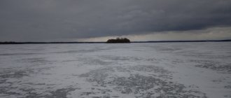
The Moscow Sea is spread over two regions: the Moscow and Tver regions. In the Capital Region, the Moscow Sea is the largest body of water, and in the ranking of the largest reservoirs in the Tver region, the Ivankovskoye Reservoir takes an honorable third place after the Rybinsk and Uglich reservoirs, the shallowest in comparison with the above. In this area, the Volga bed is blocked by a dam 22.5 meters high and more than 300 meters long. A dam with spans for releasing water was erected on the left bank. A lock with a canal was built on the opposite bank. This is where the entrance to the Moscow Canal is located. From the left bank you can see the Resurrection Cathedral, from the right - the Transfiguration Church. As mentioned above, the reservoir is located in a flooded area. During the filling of the Moscow Sea, more than a hundred settlements were flooded, including Konakovo, Ukhodovo, and Korchevo. The topography of the reservoir is mostly flat and hilly. There is a pronounced slope towards the east. The basin of the territory includes a large number of lakes. The largest: Upper Volga and Seliger lake regions. Among the flowing lakes are Sterzh and Volgo. Foam. All of them are united by the Verkhnevolzhsky reservoir. The Ivankovskoe reservoir is complexly formed and, according to its character and outline, is divided into three reaches.
- The first reach, Ivankovsky, is the deepest and widest (19 m and 8 km, respectively). It extends from the mouth of the Sozi to the dam itself.
- The Volzhsky Reach is the territory from the mouth of the Sozi River to Tver. Here the depth is subject to constant changes and tends to increase in the direction of the flow.
- The Shoshi Reach is the territory from the Shoshi Valley to the village of Turginovo. This is where the largest number of islands, channels and shallow waters are located.
Water quality
The Moscow Sea contains few minerals. Type – calcium bicarbonate. The general condition of the water is classified as polluted, and in some places very polluted. Biochemical analysis indicators show the presence of petroleum products, zinc and manganese in the reservoir. According to the criteria of biochemical and hydrochemical indicators, the Moscow Sea belongs to the type of eutrophic water bodies.
Eutrophic reservoirs, from the Greek word eutrophia, meaning “good nutrition,” are reservoirs, lakes, backwaters or oxbow lakes, as well as any reservoirs with a high level of nutrients in the water: bacteria, algae, silt and other aquatic organic objects.
As for water transparency, in summer it is 50 cm, in winter it increases to 3 meters. During the cold season, water quality deteriorates due to the decomposition of aquatic vegetation.
Physiographic characteristics
It is the largest reservoir in the Moscow region, in the Tver region it ranks 3rd after the Rybinsk and Uglich reservoirs in terms of total volume and 2nd place after the Rybinsk in terms of useful volume. Among the large Russian reservoirs, Ivankovskoye is the shallowest: water areas with depths of less than two meters at a normal retaining level account for almost half the area of the water surface[5].
Formed in 1937 by the dam of the Ivankovskaya hydroelectric power station near the former village of Ivankovo, where the Volga bed with the alluvium of medium-grained sand was blocked by an earthen dam 22.5 m high and 300 m long, passing from the left bank into a concrete spillway dam with eight 20-meter spans for releasing water. On the right bank there is a lock with an approach canal and an outport, adjacent to which is the entrance to the Moscow Canal [5][9][10].
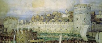
View of Korcheva from the left bank of the Volga, on the right is the Transfiguration Cathedral, on the left is the Resurrection Cathedral
As a result, 32.7 thousand hectares of land were flooded, including 7.4 thousand hectares of forests and bushes, 14.8 thousand hectares of agricultural land (7 thousand hectares of arable land, 7.8 thousand hectares of hayfields and pastures), 4, 8 thousand hectares of settlements, 3.5 thousand hectares of water bodies and 2.2 thousand hectares of inconvenient land. The territories of over a hundred villages were under water, including the once district town of Korchevy [# 1] and part of the working village of Konakovo. The process was associated with the removal of a large number of buildings, structures and communications, deforestation, forest clearance, special events with cattle burial grounds and the resettlement of about 50 thousand residents from the flood zone [5][9][10].
The normal retaining level (according to the Baltic height system) is 123.89 m, the dead volume level is 119.39 m, the forced retaining level is 124.09 m. The total volume of the reservoir at the NPU is 1120 million m³, the useful volume is 887 million m³, The surface area of the reservoir is 316 km², which is more than twice the area of pre-revolutionary Moscow. The backwater extends for 113 km along the Volga channel, 80 km along the Shoshi channel and 15 km along the Sozi channel. Length - 120 km, average width - 4 km, maximum width - 12 km, coastline length - 520 km. The average depth is 4 m, the maximum is 19 m. The drainage area, covering most of the Tver region, sections of the Smolensk, Moscow and Novgorod regions, is 41 thousand km²[5][7][10][12][13][14 ].
The relief of the reservoir basin is flat-hilly with a pronounced eastern and southeastern slope. In the northwestern part of the basin, in the area of the Valdai Upland, there is a large hilly terrain with large massifs of hills and elevations of 200-300 m above sea level. From the east it is adjacent to an area of hilly-flat relief, gradually turning into moraine and outwash plains[15]. The climate is moderate continental with prevailing westerly winds and an average annual air temperature of 3.0–3.7 °C[16].
There are many lakes in the reservoir basin. The Verkhnevolzhsky and Seligersky large lake regions are located in its northwestern part, the Orshano-Petrovsky lake region is on the swampy watershed of the Volga and Medveditsa, the flowing lakes of the Upper Volga region - Sterzh, Vselug, Peno, Volgo - are united by the Verkhnevolzhsky reservoir. The lake content coefficient[# 2] of the basin is 2.2%, the largest lake is Seliger. The density of the well-developed river network of the basin ranges from 0.30–0.35 km/km² in the Valdai Upland region to 0.12–0.15 km/km² in the Upper Volga Lowland. The rivers are fed predominantly by snow, the average annual flow module is 6.5–9.0 l/(s × km²), during spring floods about 40–60% of the annual flow passes, in summer – from 10 to 20%[18] .
Morphometric characteristics of reaches
I H W Length, km 27 84 36 Maximum width, km 8.0 2.1 5.0 Average width, km 5.9 0.9 4.0 Islandness, % 10.8 6.3 21.6 Area at NPL , km² 141 74 112 Percentage of the reservoir area 43 23 34 Average depth at normal level, m 3.3 4.9 1.7 Coastline development coefficient 6.6 - 10.1 Volume at normal level, km³ 0.46 0.47 0 .17 Percentage of reservoir volume 41 42 17 NPU - normal retaining level
I - Ivankovsky reach;
B - Volzhsky Reach; Sh - Shoshinsky reach [19]
The Ivankovskoe reservoir has a rather complex configuration, and according to the shape of the basin, the outline and nature of the banks, it is divided into three reaches - Ivankovsky, Volzhsky, Shoshinsky. In some sources, the Ivankovsky reach is called Nizhnevolzhsky, the part of the Volzhsky reach above the mouth of Shosha is called Verkhnevolzhsky, and below the mouth of Shosha is called Srednevolzhsky[20].
Ivankovsky Plyos
- the deepest (up to 19 m) and widest (up to 8 km) section of the reservoir from the mouth of Sozi to the dam, which is a lake-like expansion, always located in the backwater zone. It is characterized by a highly indented coastline, many islands and overgrown bays. The average depth is 3.3 m[21].
Volzhsky Reach
- the section from the mouth of the Sozi to the city of Tver. It is located in a zone of variable backwater and looks like a river with a width of 900 to 1500 m with hilly banks. The depth increases downstream[21].
Shoshinsky Reach
— the flooded Shoshi valley from its former mouth to the village of Turginovo. Here, open water spaces are combined with numerous islands, channels and overgrown shallow waters, often turning into coastal swamps[21].
Holidays on the Moscow Sea
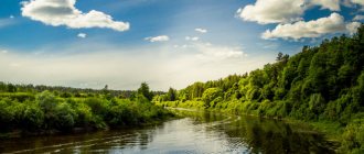
Today, the Moscow Sea is one of the most popular tourist sites in Moscow and the Moscow region. The nature of the reservoir is beautiful and clean, and there are many boarding houses and tourist centers on the territory. Not only residents of the capital, but also guests from neighboring regions relax here. Many of the visiting tourists get here by car and relax like savages, setting up tents on the shore. The best way to appreciate the beauty of the Moscow Sea is from the deck of a ship, as there are many attractions, mounds, and architectural monuments from the times of Tsarist Russia around the reservoir. In addition, on the territory of the Moscow Sea you can engage in extreme sports (surfing, yachting, jet skis).
The best vacation spots on the Moscow Sea
The most attractive place for tourists in the Moscow Sea is Ukhodovo Island. It is located on the Volga River. The island acquired its name in honor of the village of Ukhodovo, which was flooded during the construction of a canal. On the territory of the Moscow Sea there are a large number of lakes, rivers and reservoirs. But the most popular, undoubtedly, is the Istra Reservoir. Geographically, it is located in the north-west of the region. This is where the cleanest water is. However, there is no direct access to the reservoir. In order to get to it, you need to travel on foot through the forest along the Nudoli River.
History of the Ivankovo Reservoir
The Moscow Sea, as this basin is otherwise called, appeared in 1937. Although the idea of connecting the Volga and Moscow Rivers arose under Peter the Great. Then the project never came to fruition. This happened more than two centuries later. Construction of the canal began in 1932, and the reservoir was built two years later. Not far from the village of Ivankovo, a dam 22 meters high was erected, which blocked the Volga riverbed. During the work, meadows, swamps and more than a hundred settlements were flooded. The resulting object is the second stage of the Volga-Kama cascade. On the shores of the Moscow Sea are the cities of Konakovo and Dubna.
Recreation centers on the Moscow Sea
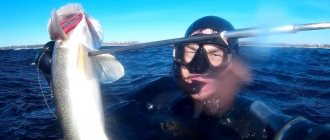
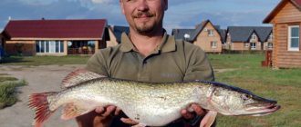
At the end of the last century, even during the existence of the Soviet Union, there were more than 35 boarding houses, tourist centers and recreation centers on the territory of the Moscow Sea. For several decades, the tourism business in this area has been developing inactively, however, in the last five years, many entrepreneurs providing tourism services have concentrated here. If the growth rate of the tourism business in the Konakovo region continues, then the Moscow Sea region can successfully become a leader among the resorts in the central part of the country. The pearl of the Moscow Sea is the youth tourist complex “Zavidovo”, famous throughout the country. "Karacharovo" is the main boarding house in the All-Russian Federation of Trade Unions. This complex specializes in active treatment and for the most part is a health resort. One of the largest complexes of the former Rosstourist, the Verkhnevolzhsky medical boarding house, also operates here. Since the tourism industry in this area is actively developing, there are more and more tourist complexes here every year. One of the most popular among new ones is the rural hotel “Daphne”. This is a four-star complex, which is the only private complex of this type in the middle zone. The recreation center "Pikhtovaya Alleya" is located on the cleanest territory of the Moscow Sea. Most often, tourists come here to fish. Fishing services are actively developed here. Absolutely all necessary gear is provided for rent, as well as boats, houses and fishing equipment. In addition, it is in this part of the reservoir that the largest number of fish live. Here you can catch both pike and catfish. Renting a boat and fishing gear is quite inexpensive. For evening relaxation there is also everything you need: gazebos, tents, barbecues, outdoor furniture, air mattresses and much more. The recreation center "Fir Alley" is located in one of the most picturesque areas of the bay. You can relax here at any time of the year.
Rest on the Ivankovskoye Reservoir
At least 2.5 million people come here on holiday every year. According to experts, the recreational potential is twice this figure. These places are especially popular in the summer. There is clean and clear water, gently sloping shores and many coves. There are also about 300 islands on the Ivankovskoye Reservoir. Most of them are overgrown with forests or swamps. There are several bays here, including Fedorovsky, Sukharinsky, Korovinsky.
There are a huge number of boarding houses and recreation centers on the banks. Here travelers stay in comfortable conditions in guest houses and rent the necessary equipment. Lovers of being “savage” in nature often come to the Ivankovskoye Reservoir with tents. Both in wooded areas and in open areas you can conveniently set up a bivouac. Part of the Moscow Sea territory is under state protection. The Zavidovo Nature Reserve is located here.
In winter, the frozen pond becomes a haven for thrill-seekers. For a decade and a half, the Moscow Sea Festival of Extreme Sports has been held here.
Moscow Sea how to get there from Moscow
The Ivankovskoye Reservoir is located in the Moscow and Tver regions, 130 km north of the capital. Getting to the Moscow Sea is not difficult. You need to move along the Leningradskoye Highway through Zelenograd, Solnechnogorsk and Klin. At the end of the route, you need to turn to the Novozadovsky village and then drive along the route to the required stopping place.
Train schedule with changes, ticket prices
You can get to the Moscow Sea station from Moscow from the Leningradsky station. There are direct routes with departures at 14:59, 18:10, 19:30, 20:43 and 22:14, as well as several trains with transfers to Klin, Redkino and Kryukov. The first train towards the Moscow Sea departs at 14:48, the last one at 22:14. The total travel time is 2-2.5 hours. The ticket price at the beginning of 2019 is 300 rubles. Trains depart daily. A more detailed schedule of commuter trains to the Moscow Sea can be found on any available electronic schedule or simply by arriving at the station, since the train schedule is rarely subject to changes.
Moscow Sea on the map
Discussions and reviews about the Moscow Sea
Muscovites are very fond of the Konakovsky district and trips to the Moscow Sea. The area is located near the city, the area is very large. Anyone can find a place for a tent here at any time of the year and even during the busiest season. For those who want to go fishing, there are special camp sites with all the necessary paraphernalia for rent. Those who want to relax among the savages can easily find a place to stop. In addition, daily cruise ships provide another opportunity to relax and escape from the bustle of the city.