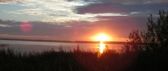
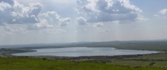
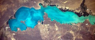
In the north of the Chelyabinsk region of Russia, near the city of Verkhniy Ufaley and the village of Vishnegorsk, Lake Arakul is located. The reservoir is of tectonic origin and is located in the north of the Ural Mountains, in the mountain yayla. The lake is quite large. The Arakul flooded over 3 km in length and almost 2 km in width. The reservoir is quite respectable in depth: the average is about 5 meters, but in the eastern and southern parts of the lake there are indicators of more than 10 meters. The maximum elevation of Arakul is 12 meters. The drainage basin area is 21.6 square meters. km. The chemical composition of the water in the lake is mineral; mineralization is 240 mg/l.
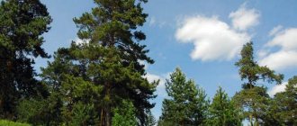
The forests located next to the lake are inhabited by squirrels, hedgehogs, hares, foxes, moose, bears and lynxes. The last of these are rare and are not suitable for the reservoir itself.
View gallery
Springs and flowing rivers
Arakul is a passing lake. Two small rivers flow into it - Olkhovka and Kaganka. Arakulka also gets its source from the lake. It is this river that connects Arakul with the water system of the Chelyabinsk region. The local name for the lakes in this area is Kasli or Kasli. From Tatar “kasli” means “blue hollow”. Lake Arakul is surrounded by green forests and is a favorite vacation spot for residents of the Chelyabinsk region. At the bottom of Arakul there are many small springs, because of this the water is constantly cold and warms up very slowly. Even in summer it retains its coolness.
How to get there
You can get from Chelyabinsk to Arakul by bus, by car or by taxi.
Bus
Every day from the Chelyabinsk bus station "South Gate" to the city of Verkhniy Ufaley buses No. 549, and from the Central Bus Station - No. 683/4 and 683. From Verkhniye Ufaley to the village of Silach there is bus No. 15. Then you need to get there on foot (more than 7 kilometers ), by taxi or hitch a ride. On the popular service for tourists Tutu.ru you can find a bus schedule from Chelyabinsk to Verkhniy Ufaley.
Or from the Central Bus Station to the village of Vishnegorsk you can take bus No. 687. From Vishnegorsk to Arakul it is about 17 kilometers, so you can get there by hitchhiking or taxi.
From Yekaterinburg to Lake Arakul from the Severny bus station to Verkhny Ufaley, buses No. 563 depart. Then you can transfer to bus No. 15 and get to the village of Silach, and from there to Arakul by minibus or taxi. See the bus schedule from Yekaterinburg to Verkhny Ufaley on Tutu.ru.
Automobile
From Chelyabinsk, take the Sverdlovsk Highway through the villages of Kazantsevo, Novoye Pole, Dolgoderevenskoye, then turn right towards lakes Urefty, Uzunkul, Agashkul, Kaldy, Karagaikul, Kuyash, Malye Allaki, then turn left and follow Lake Bolshiye Allaki, the village of Kisegach, lakes Kirety, Big Kasli, then after Kasli turn right and follow to Arakul. From Chelyabinsk to the lake 160 kilometers. You will spend about 2 hours 40 minutes on the way. You can see the route laid out on a Google map.
From Yekaterinburg, take the Koltsovsky Highway, then along the EKAD and the Chelyabinsk Highway past the village of Borodulino, the villages of Oktyabrsky, Olkhovka, Kashino, Ilyinsky Pond, lakes Bagaryak, Maly Bagaryak, Boevskoye, Tenyak, Cherkaskul, Maloe Yamskoye, Bolshoye Yamskoye, Karaguz, at the fork at Lakes Malye and Bolshie Allaki turn right, follow the lakes Bolshie Kasli and Kireta, Zatsepinsky pond, Lake Bolshoi Kagan. The distance is 148 kilometers, you will spend about 2.5 hours on the road.
You can also use the services of local taxi services - Yandex.Taxi and Uber.
Source
Hydrology
- Availability of permanent drainage: yes, wastewater.
- Swimming pool: Kyshtym River.
- Bottom: muddy.
Chemical composition
- Water: fresh.
- Salinity: 0.3 g/l.
- Water class according to salt composition: hydrocarbonate-magnesium.
- Coordinates: 55°37′10″ N. latitude, 60°39′16″ e. d.
- Altitude: 253.4 m.
- Coastal landscape: the surroundings of the lake are overgrown with mixed forest, in some places swampy (most severely on the western shore). There are several recreation centers and other recreational facilities on the northern and southern shores, and collective gardens on the eastern shore. Dirt roads stretch almost along the entire coast of the lake.
Territorial location
- Country Russia . Region: Chelyabinsk region . Districts: Argayashsky, Kyshtymsky.
Interactive map
The lake is located not far from the territory of the East Ural radiation trace, which was left after the accident at the Mayak production facility, which occurred in the 50s of the 20th century. Measurements made by specialists from Tomsk State University showed that the natural background radiation in the reservoir was 50 times higher.
Landscapes near the lake
3
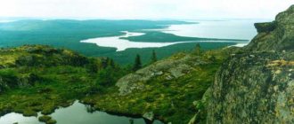
The surrounding landscapes add uniqueness and special beauty to the place. Among the forests there is an interesting rocky massif - Shikhany (Arakul Shikhan). Locals call it the Chinese Wall. It really does look like a wonder of the world. The fact is that at the top of the rock it stretches 2 kilometers long in bizarre shapes in the form of stone ridges. The height of the climbs is 60 m, and the width of the ridges reaches 40 m. From a distance, Shikhan resembles an impregnable fortress. The only difference is that it was created by nature. This is a fairly popular place among climbers. Training and competitions are often held here. However, there are still traces of human activity in this place. At the foot of the cliff, archaeologists have found several ancient sites. They date back to the Bronze Age (35-11 centuries BC) and the Early Iron Age (13-4 centuries BC). And in the stones at the top of Shikhan you can see dozens of depressions about 2 meters in size. Scientists suggest that they were used as a place for sacrifices or for performing other ritual rites.
Geography
- Coordinates: 55°37′10″ N. latitude, 60°39′16″ e. d.
- Altitude: 253.4 m.
- Coastal landscape: the surroundings of the lake are overgrown with mixed forest, in some places swampy (most severely on the western shore). There are several recreation centers and other recreational facilities on the northern and southern shores, and collective gardens on the eastern shore. Dirt roads stretch almost along the entire coast of the lake.
Territorial location
- COUNTRY: RF . Region: Chelyabinsk region . Districts: Argayashsky, Kyshtymsky.
Interactive map
This is interesting: Argazin Reservoir: fishing and what kind of fish is found
Walking around the Urals. Akakul.
Lake Arakul is located in the north of the Chelyabinsk region. Translated from Bashkir it means “intermediate lake” or “lake between the mountains”.
The length of Lake Arakul is about 3 kilometers, the width is 2 kilometers. The average depth is 5.3 meters, and the maximum is 12 meters. The greatest depths are in the eastern and southeastern parts of the lake. The height of the lake above sea level is about 300 meters. The lake is a hydrological natural monument.
The lake is waste. Through a system of swamps and channels, water is discharged into Lake Ulagach, located east of Akakul. In the western part, a river flows out of the lake and flows into Lake Bolshaya Akulya. On the shores of the lake there are numerous recreation centers and children's sports and recreation camps. Widespread recreational use is associated with high water quality and picturesque landscapes.
Depth - just over 3 meters. The water in the lake is clean, transparent, slightly mineralized (only 300 mg/l), with a large complex of microelements. According to the chemical composition, the water belongs to the soda type of the hydrocarbonate class of the magnesium group.
The Kaganka and Olkhovka rivers flow into it, and the Arakulka river flows out. Through this river, Lake Arakul is connected to the Kasli system of lakes. There are many springs in the lake, so the water in it is cold and warms up slowly in summer. Water transparency reaches 6 meters. The bottom of the lake is sandy and rocky, and closer to the center it becomes muddy.
Akakul, a typical reservoir of tectonic origin in the Ural region, is located in the Argayash region, 85 - 100 kilometers from Chelyabinsk (taking into account the route and access to the reservoir). The lake is elongated in shape with a water surface length of 5-3 km, average depth 4-6 meters, maximum (near the islands) up to 12 meters.
The southern shore is the Akakul tract, the western shore is connected to Lake Bolshaya Akulya, the eastern shore is connected to Lake Ulagach. There are recreation centers and sports camps around the reservoir.
Commercial fishing is carried out on the reservoir (in the past). The main maintenance of fish resources is stocking and spawning. In the past, recreational fishing was paid, but currently there are no permits. The spawning ban is carried out in accordance with the general provisions on fishing in the Chelyabinsk region.
Route:
Western bank of the reservoir. Chelyabinsk (Sverdlovsk tract) – Argayash – Kuznetskoye – Lake Akakul. A sign of the lake after 12 kilometers of the road to Kyshtym.
Eastern Shore. Chelyabinsk (Sverdlovsk tract) – Argayash – Novogorny – Bizhelyak station. Further through the crossing and 3 kilometers of forest road.
Peculiarities
The lake is located between the village of Vishnegorsk and the city of Verkhniy Ufaley. Nearby are the Maly and Bolshoi Kagan, Buldym and Svetlenkoe lakes.
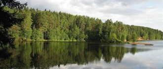
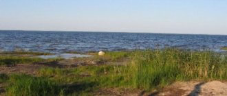
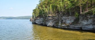
The banks are high, uneven, rocky, there are wetlands, but they are few. The water is clean and transparent. The reservoir is surrounded by mountains and forest. In the east of the lake there is an island 125 meters long and 17 meters wide.
Arakul from Bashkir means “distant lake”: the shores of the reservoir are high, rocky, it seems that you simply cannot approach the lake, and one of the main attractions of these places is the Arakul Shikhany rock massif.
© Dmitry Stepanov
Arakul Shihans
The rock massif has become one of the main attractions of these places. The length is 2 kilometers, the width is 40–50 meters, and the height of the ridge is 60 meters. You can often meet climbers here.
The summit of Chamberlain is the highest point of the massif (approximately 80 meters). It offers a beautiful view of the Cherry Mountains and 11 lakes located in the vicinity of Arakul.
The Arakul Shikhans are notable not only for their appearance, but also for their archaeological finds. Experts found two-meter deep depressions at the top of the rock massif. It is believed that they were made by ancient people to perform sacrifices here. Archaeologists also discovered sites of ancient people on the shores of Lake Arakul.
© Valentina Pushkareva
Tourists
Lake Arakul (Chelyabinsk region) and its surroundings are very popular among tourists. Every year more and more people go to these regions for recreation. Slowly but surely the infrastructure is developing here, routes are being organized - weekend tours. There is a parking lot for camping. This is now the most common type of holiday. Also on the left bank of the lake, the Arakul Village, a guest complex, was built. You can rent houses, catamarans, boats, barbecues, and sports grounds. In winter, sleighs, skis, snowmobiles and skates are available for rent.
How to get there (get there)
The following is a list of entrances (approaches) to the reservoir - 2 options.
Eastern Bank (from Yekaterinburg)
- Coordinates: 55°36′23″ N. latitude, 60°40′53″ e. d.
- Distance from Yekaterinburg: 176 km.
- Delivery option: any car.
- How to get there: from Yekaterinburg you should go in the direction of Chelyabinsk. After Tyubuk, turn right - onto Kasli, and continue driving in the direction of the city, having passed which, you need to move further - to Kyshtym, on the outskirts of which there will be a sign “Karabash / Chelyabinsk”, a railway crossing and a three-way intersection, at which you need to turn left. Next, follow the signs towards Chelyabinsk until you leave the city. Next - through the village of Kaolinovy towards Kuznetsky. After a few kilometers there will be signs for Akakul, Bizhelyak and recreation centers - after them you need to turn left, then go to the fork, at which you turn right (there will be a sign “bereg recreation center”). After a while, a lake will appear to the left of the road.
Eastern Shore (from Chelyabinsk)
- Coordinates: 55°36′23″ N. latitude, 60°40′53″ e. d.
- Distance from Yekaterinburg: 98 km.
- Delivery option: any car.
- How to get there: from Chelyabinsk you should go in the direction of Yekaterinburg, at the junction near Dolgoderevensky, turn to Argayash and then move to this settlement. On the outskirts of Argayash there will be a sign to Kyshtym, Ozyorsk and Kuznetskoye - turn left, where you need to turn, then move in this direction. On the outskirts of Kuznetsky - turn towards Kyshtym - right, then drive a few kilometers to the signs “Akakul / Bizhelyak” and “recreation center”, after which turn right. Next - as in the previous version.
Where is it, how to get there
The Arakul Shikhan, photographs of which convey the majestic impression of the beauty of these fabulous places, is located in the Verkhneufaleysky urban district of the Chelyabinsk region, 6 km east of the railway station in the village of Sivach.
You can get there by commuter trains.
- Suburban trains depart from Chelyabinsk daily from the Main Station 2 times a day: at 9-12 and 18-35. The ticket can be purchased immediately before boarding. The fare is about 350 rubles. The duration of the trip is almost 3 hours.
- Electric trains from Yekaterinburg to Verkhniy Ufaley leave at 10-03 and 17-57. The fare is about 200 rubles, travel time is 2 hours 40 minutes. Next, you need to change to an electric train towards Chelyabinsk and go to Silach station.
Arakul Shikhan and Lake Arakul
You can get there by regular intercity bus.
| Point of departure | Bus station | Flight number | Destination |
| Chelyabinsk | South Gate | 549 | Verkhniy Ufaley |
| Central | 683 and 683/4 | Verkhniy Ufaley | |
| Central | 687 | Veshnegorsk | |
| Verkhniy Ufaley | bus station | 15 | Strongman |
| Ekaterinburg | Northern | 563 | Verkhniy Ufaley |
It is more comfortable to travel to your destination by private car:
- From Yekaterinburg, the distance is 140 km, the travel time is from 2.5 to 3 hours, you need to follow the M5 and M36 highways, after the village of Tubuk turn to Kasli, and then follow the signs to the mountain range itself.
- From Chelyabinsk you will need to travel 165 km, although the distance is much shorter in a straight line. First, the route goes along the M36 highway to Kasli, there you should drive through Zavety Ilyich Street and turn right at the intersection, then follow the signs to the Arakul Shikhan.
It is worth considering that at the end of the path there is a dirt road, which is quite bumpy in dry weather and impassable in places during the rainy season. You can leave your car in a forest clearing or near a lake, and then walk along a clearly visible well-trodden road.
The route can be plotted using a car navigator by entering GPS coordinates: 55.984378 and 60.492484.
Ecology of the reservoir
The water in the lake is clean. Mineralization - no more than 300 mg/liter. The chemical composition of water belongs to the hydrocarbonate class according to the soda group and magnesium group. In terms of softness, water belongs to the first category. A mixed forest (linden, pine and birch) grows around the lake. It contains a lot of mushrooms and berries that can be collected directly on the territory of recreation facilities. Small rocks are scattered in the forest. Fruit-bearing trees and shrubs grow: rowan, cherry, apple, raspberry and bird cherry. Birds, squirrels and hedgehogs live in large numbers in the forest. In summer, the lake water warms up well and remains warm until the autumn cold. Due to the absence of industrial enterprises, the composition of the water and the large amount of vegetation, the air on Akakul is clean and fresh. It has a beneficial effect on the functioning of all organs and systems of the human body. The bottom of the reservoir is predominantly muddy. On the beaches they clear it, the bottom there is sandy. The eastern shore is steep and rocky. There are 3 rocky capes and islands covered with vegetation.
Lake Arakul,
Lake Arakul is a beautiful, clean, picturesque body of water. Recognized as a natural monument. Near the lake are the most interesting Shikhan rocks.
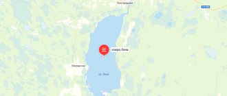
Location:
Lake Arakul is located in the Kasli district, Chelyabinsk region. Approximately at the same distance from three cities - Snezhinsk, Verkhniy Ufaley and Kasley.
Distance from Yekaterinburg to Lake Arakul: approximately 140-150 km. Travel time on average: 2-2.5 hours.
Distance from Chelyabinsk to Lake Arakul: 160 km (2-3 hours to get there).
Nearby are Lake Silach, Lake Sungul, Lake Kirety.
Very close are the lakes Maly Kagan and Bolshoy Kagan.
Nearest settlements: village. Arakul, village Strongman, Vishnegorsk city.
Reference:
Lake Arakul reaches a depth of 12 meters (maximum point), the average depth is 5 meters.
The area of the water surface is approximately 3 km2.
Several rivers flow into the lake and Arakulka flows out, turning into the Gorkaya River.
There is one elongated island on the lake. Popularly it has a name: Island of Love.
The bottom of Lake Arakul is muddy. In some places there are thickets of reeds.
There are forests and mountains around, giving a picturesque view.
The water in the lake is very clean, transparency reaches 6 meters!
Since 1969, Arakul has the status of a natural monument.
There used to be a lot of crayfish in the lake, but in recent years there have been none.
Name and legends:
The literal translation of the name of the lake: “lake between the mountains” (“ara” - “between”, “kul” - “lake”). But there are other translation options. For example, “distant lake” or “lake of tears”.
There are many legends about the lake. One of the most common is about the love of a girl and a young guy. The evil spirit tried to separate them, but failed. Then he turned the guy into stone. And the girl cried and cried, and holes and paths appeared on the stone, and the lake at the foot became large and clear, like a tear. And when the spirit wanted to take the girl, a boulder fell off the stone and hit the villain. Then he got angry and turned the beauty into stone. A little later, the guy’s father, an old hunter, took revenge on the spirit, wrapped him in belts and threw him into the middle of the lake. They say that this is why ripples appear so often in the center of Arakul, even when the entire lake is smooth and calm.
Rest:
The shores of the lake are flat. Some are rocky, some are sandy.
Possible as a “wild” holiday - there is a place for a tent camp (mainly on the northern shore).
It’s also civilized – there are guest houses. There are also boat rentals, water skiing, volleyball courts and all the infrastructure.
You can also stay in one of the nearby cities.
Entry fee: 500 rubles.
Near the shores it is very shallow.
Fishing is available from a boat. But they claim that little fish is caught.
What else to see?
Not far from the lake are the Shikhan rocks. Main local attraction.
Shikhan is a rock massif made up of huge boulders and layers of granite containing quartz. Located on the top of Mount Arakul. The length of the ridge is 2 km.
It was here, at the foot of the massif, that traces of ancient man were discovered.
Some rocks resemble animals in their outlines and have corresponding names - Elephant, Turtle, Lioness, Eagle, etc. There is the Old Woman rock, the Palm rock and others.
Shikhan is a favorite place for rock climbers, tourists, and photographers (there is a beautiful view of the surrounding area, lakes, mountains, forests, and you can see cities in the distance).
Some recognize Shihan as a place with the strongest energy.
Pros and cons of holidays on Lake Arakul:
Pros:
- very beautiful area, mountains, rocks, forests, fresh air,
- the lake is transparent, clean, is a natural monument,
- garbage is removed, cleanliness is monitored,
— one of the most interesting sights of the Urals, the Shikhan rocks, is located nearby.
Minuses:
— there are a lot of vacationers during the season, there is nowhere to put up a tent,
— poor access to the lake (country road),
- paid entry,
— there are a lot of ticks in the forest area! (the beach has been processed).
How to get there?
From Yekaterinburg:
By car:
We leave Yekaterinburg towards Chelyabinsk, move along the M-5 highway to the village. Tube. Then turn onto Kasli (right). We reach the city and turn to Verkhniy Ufaley (right), and then after about 8 km turn right again, following the sign for Vishnegorsk. From Vishnegorsk we follow the signs to Arakul.
Access to the lake by passenger cars is only possible from the village. Arakul or next to Shikhan.
By public transport:
You can get from Yekaterinburg to the city of Kasli or the city of Verkhny Ufaley by bus, and from there take a taxi to Arakul.
Or take the train from Yekaterinburg to Silach station (direction Verkhniy Ufaley). From there it is about 4-5 km on foot.
From Chelyabinsk:
By car: exactly the same as from Yekaterinburg. We drive along the M-5 highway to the village. Tube, turn left onto Kasli. And then - the description above.
Recreation centers on Lake Arakul:
— “The village of Arakul”
You can also stay in Vishnegorsk, or near the Sungul and Bolshie Kasli lakes (there are recreation centers).