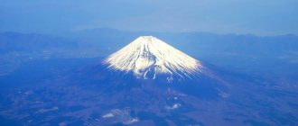
Mount Fuji - in addition to being an active volcano, it is also the highest mountain in Japan, whose height is 3776 m above sea level. The volcano is located on Honshu Island, southwest of the capital Tokyo. In 2013, it was included in the UNESCO World Heritage List as a cultural heritage site and source of artistic inspiration. This volcano is revered as a sacred mountain and is Japan's calling card.
Geological characteristics
The origins of Fuji , whose topography has been affected by volcanic activity, are unknown. According to folk tradition, the mountain was formed after an earthquake in 286 BC. Volcanologists believe that the current volcano is the result of four separate phases of volcanic activity that characterize its shape and structure. The regular conical shape of the mountain is the result of the overlapping layers of hardened lava and volcanic ash.
The main crater of Mount Fuji is located on a fault that is part of the Pacific Rim, between the Eurasian Plate, the Okhotsk Plate and the Philippine Plate. Although the main phase of Fuji's volcanic activity occurred 11-8 thousand years ago, the volcano is not considered extinct. Since 781 there have been 10 eruptions, including three significant ones. The last eruption occurred from October 28, 1707 to January 1, 1708. It was accompanied by a strong earthquake on October 28, 1707.
A consequence of volcanic activity and the stratification of the structure of the Fuji volcano, there are 150 solidified lava flows, among which the largest are the Mishima and Mano flows. These flows have created numerous natural caves with lava rocks along the slopes of the mountain.
In addition to the caves, you can also observe the characteristic “lava trees” (lava coating around a tree trunk left by a lava flow).
The surface of the mountain is covered with valleys and gorges formed by the corrosion of wind, water and snow over the centuries. The largest and most extensive of these gorges, goes to the western side of the peak at an altitude of about 2200 m. The gorge is 2 km long with a width of 500 m, and a depth of 150 m.
HOKKAIDO ISLAND AND NEARBY ISLANDS. SHIRETOKO-AKAN VOLCANIC SERIES
Hokkaido Island is the region of the end junction of the Sakhalin-Japanese and Kuril island arcs.SHIRETOKO-AKAN VOLCANIC SERIES
It continues the chain of the South Kuril Islands. The volcano is located here from northeast to southwest. Shiretoko, Shiretoko-Iwo-Zan, Rausu, On-nebetsu, Unabetsu, Syari, Kuttiyaro caldera and many others.
Shiretoko (1254 m)—on the Shiretoko Peninsula. 44° 13′ N, 145°20′ E Pleistocene stratovolcano; andesites and their pyroclasts. In the area of the volcano there are solfata fields and hot springs. In 1936, an eruption of molten sulfur occurred from one of the parasitic cones.
Shiretoko-Iwo-Zan (1536 m) - on the volcanic ridge. Shiretoko Peninsula. 44°08′ N, 145° 10′ E Stratovolcano; pyroxene andesites and their pyroclasts. Dm. cone 10 km. At the top are the explosive craters Kita (dm. 1200 m), Naka and Minami (dm. 1500 m). Vlk. known for eruptions of molten sulfur. There are hot springs in his area.
Rausu (1661 m) continues to the south a series of volcanoes. Shiretoko Peninsula. 44° 05′ N. latitude, 145° 07′ E. village Stratovolcano; pyroxene andesites. Dm. cone 7 km. There are numerous hot springs around it.
Onnebetsu (1331 m) - in the southern part of the Shiretoko Peninsula. 44° 01′ N, 145° 02′ E d. The structure of this stratovolcano is similar to the previous two.
Unabetsu (1419 m) - merges with the previous volcano. 43°53′ N, 145° 53′ E e. Pyroxene andesites. There are hot springs in his area.
Syari (1545 m) is the southwestern end of the volcanic ridge. Shiretoko. 43°45′ N, 144°45′ E It forms a hill among the coastal plain, composed of horizontally lying Neogene deposits. Shield stratovolcano dm. 25 km; pyroxene andesites and their pyroclasts.
Further to the southwest of the ridge. Shiretoko grades into a vast volcanic plateau covered with Pleistocene ignimbrites and pyroclasts. It contains large calderas: Kuttyaro, Masyu and Akan.
Kuttiyaro Caldera (581 m) is the largest in Hokkaido. Her dm. 20 and 26 km. Located in the center of the volcanic plateau, among ignimbrites. 43°35′ N, 144°20′ E In the Pliocene and early Pleistocene, a large shield volcano formed here. Kuttiyaro, composed of andesites and tuff breccias. In the Middle Pleistocene, acidic pyroclasts erupted and a caldera formed.
In the late Pleistocene (20 thousand years ago), volcanism reached its maximum development; a large number of pyroclasts were again erupted from the caldera, fields of late Pleistocene ignimbrites formed around it and pyroclastic flows along river valleys. Later, secondary volcanic groups arose on the caldera swell: Mokoto (1000 m) on the northern part of the swell, Nakayama on the southern segment. The Atsanupuri volcanic group formed in the eastern part of the caldera.
Volcano Atsanupuri
(574 m) - 43°37′ N, 144°26′ E. d. Complex volcanic massif consisting of volcanoes. Atsanupuri (510 m), Rishiri (395 m), Oputateshike (504 m), Nupuri (230 m), Maruyama (226 m), Wakoto Oyakotu (216 m), Tosamoshibe (370 m), Nibishi Oyakotu (195 m ), Sawan Tizappu (521 m), Makuvan Tizappu (574 m). Atsanupuri has dm. bases 850 and 950 m. This is an explosive crater dm. 1000 m with a central dome of hypersthene andesites. The somma is formed by augite dacites.
Nakajima (365 m) forms an island near the southeastern shore of the lake. Kuttiyaro. 43°44′ N, 144° 10′ E Dm. volcano cone 3 km; Late Pleistocene hypersthene andesites of tholeiitic magma.
Mashu Caldera (858 m)^in the eastern part of the Kuttiyaro Caldera. 43°34′ N, 144°34′ E The formation of the volcano, and then the Masyu caldera, went through four stages. In the first of them (about 20 thousand years ago), there were emissions of pumice from the Kuttiyaro caldera in a volume of about 100 cubic meters. km. Pumice covered a large area and spread in the form of pyroclastic flows along the river valleys that were formed after the Late Pleistocene regression of the sea. In the second stage (17 - 12 thousand years ago), the shield volcano was formed. Masyu, composed of augite and hypersthene basalts and andesites (its length reached 17 km). It was planted on a ring fault on the eastern side of the Kuttiyaro caldera. In the third stage (11–7 thousand years ago) there was a new oxidation of magma, new eruptions of pumice of andesitic composition. The subsidence and formation of the Mashu caldera began. This is a mixed caldera, Krakatoa-Glencoe, dm. its 9 km. There is a lake at the bottom. In the fourth stage (the last 7 thousand years), an andesite-dacite complex of lavas and pyroclasts was formed. Small volcanic cones and lava domes appeared on the caldera ridge. Examples of these are the Kamuinupuri cinder cone and the Kamuisu lava dome.
Akan Caldera
(400 m)—in the southern part of the vast ignimbrite plateau. It has the shape of an ellipse dm elongated in the southwestern direction. 24 and 13 km; Middle Pleistocene age. It contains the active Holocene stratovolcano Akan, or Oakan (1371 m), 43°27′ N, 144° 10′ E. d. Pyroxene andesites and their pyroclasts. Dm. 7 km. To the west in the caldera there is a dammed lake. Akan. Northeast of the stratovolcano in the caldera there is a dammed lake. Heavens. On the slopes of volcano numerous parasitic cones.
In the southwestern part of the Akan caldera there is an active volcano. Meakan (1503 m). 43°23′ N, 144°01′ E d. This stratovolcano is closely merged with the volcano. Akan-Khuzi (1400 m). The tops of both cones have small crescent-shaped craters. Slopes of volcano broken by radial faults. To the east of the Meakan cone (in the same Akan caldera) is the Furebetsu stratovolcano (1300 m). Its structure is similar to the previous ones.
TAISETSU-TOKACHI VOLCANIC RANGE
It is located in the Tokati Highlands, which have been isolated in relief since the Paleogene. Later, volcanoes arose here repeatedly, and the highlands grew due to neighboring troughs. The last outbreak of volcanism occurred in the Pleistocene. It led to the formation of a number of large volcanoes, planted on the covers of sintered tuffs of Pliocene-Pleistocene age. Vlk. formed by a diverse complex of rocks - from basalts to rhyolites of the calc-alkaline type.
Taisetsu (2290 m) - on board the newest Ishikari trough, on the banks of the river of the same name. 43° 41′ N, i42°53′ E d. Volcanic massif dm. 14 and 11 km. In its center is the caldera dm. 2 km of explosive origin. On the outer slopes of the caldera there are parasitic cones confined to the zone of ring faults framing the caldera. These are the domes: Kuro (1984 m), Keigetu (1945 m), Riun (2131 m), Hokutin (2246 m), Hakuun (2229 m).
Tokati (2077 m) - in the southern part of the ridge. Tokati. 43°25′ N, 142°41′ E Shield volcano, dissected by erosion into a number of peaks - former volcanoes. The latter form a row extending to the southwest, in the middle of a vast caldera.
The following volcanoes are located here: Biel (2052 m), Tokati (2077 m), Khurano (1912 m), etc. The total length of this series is 12 km. 2 km southwest of Tokati peak there is an ancient explosion crater dm. 1 and 2 km. 1 km northwest of the Tokati peak is the crater dm, formed in 1926. 1 km. It is open to the northwest. There are many explosion craters around it, formed in 1962. The largest of them is in the area of the volcano. Taysio. In the area of the volcano. Shirogane hot springs.
Climatic conditions
Due to the high altitude of the peak, there are different climate types along its slopes. Much of the mountain has an alpine climate , characterized by cold temperatures and strong winds blowing from west to northwest. Due to severe turbulence, a Boeing 707 911 crashed into a mountain on March 5, 1966, killing 124 people on board.
The summit is only snow-free for a short period during the summer months, although sudden snowfalls can occur even during the hottest time of the year.
Tourism development of Mount Fuji
Mount Fuji can be seen from countless points in the surrounding regions. On clear days, its peak is visible hundreds of kilometers away; however, more often than not, the view of the mountain top is obstructed by low hanging clouds or poor visibility.
The volcano and its massif are the site of numerous tourist trips and pilgrimages. The official climbing season is July and August. At the very top there are four hiking trails with ten paid tourist huts. Up to 2400 m above sea level in summer it can be reached by asphalt road by car or cruise bus . There is a meteorological observatory at the top.
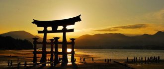
Near Mount Fuji, in Yamanashi Prefecture, there are lakes:
- Kawaguchi;
- Yamanaka;
- Sai;
- Motosu;
- Shoji.
The mountain is officially open for climbing in July and August on several routes.
In June 2009, Japan's Mount Fuji Shizuoka Airport opened to several domestic and international flights.
On the southwest side are the Shiraito Falls, and on the northwest side are the Fujiten ski areas. The entire area is a target of mass tourism and part of the Fuji-Hakone-Izu National Park . It also includes the plain and the infamous Aokigahara Forest.
The mountain is officially open for climbing in July and August on several routes.
, Japan's Mount Fuji Shizuoka Airport opened to several domestic and international airlines.
VOLCANO UNZEN
Mount Unzen is a group of composite volcanoes, the highest of which is Mount Fugen, located at about 4,462 feet above sea level. In 1792, Mount Razzen suffered a violent eruption that killed up to 15,000 people. In fact, it was perhaps the deadliest destruction in Japanese history. Mount Unzen is located on a peninsula east of Nagasaki. Mount Unzen is known as the deadliest of all volcanoes in Japan, having recorded several violent eruptions with numerous casualties. However, it is also a popular tourist destination due to the hot springs on its southwestern side. Unzen calmed down for several years, but it erupted in 1990, after which many periodic eruptions followed. Also, in 1991, a group of journalists and scientists ventured into the mountain's danger zone, where the mountain erupted and killed them all. The last eruption ended in 1995, as the mountain remains dormant. Unzen" is now also considered part of the Unzen-Amakusa National Park, which has become a popular destination for attracting visitors from all over the world.
VOLCANO UNZEN
VULCANO ASO
Mount Aso is located in Kyushu Kumamoto Prefecture. It is an active volcano with one of the largest calderas in the world, with a circumference of about 120 km. It is also the largest active volcano in Japan and one of the largest in the world. It stands majestically in Aso Kuju National Park on the island of Kyushu at an altitude of about 1,592 meters above sea level. The Aso Central Cone Group consists of five peaks, namely Mount Neko, Taka, Naka, Eboshi and Kishima. The highest point is the Taka peak, located at an altitude of 1592 m above sea level. The current Aso Caldera was formed by four huge caldera eruptions that occurred about 90,000-300,000 years ago. The caldera also includes the city of Aso, as well as Aso Takamori-cho and South Aso-mura, which has been designated a Site of Scenic Beauty, or Natural Monument. According to the study, Mount Aso has produced more explosive eruptions than any other volcano in the world, which is mainly composed of basaltic and emissive ash with stromblic magmatic activity.
VULCANO ASO
VOLCANO KIRISHIMA
Mount Kirishima is a 1,700 meter high group of active volcanoes located in Kagoshima Prefecture and Miyazaki Prefecture, Kyushu, Japan. The highest peak is Karakuni-dake, and other peaks are Takachiho Mountain and Shinmoedake, both of which are active volcanoes. Since 742, many eruptions have been recorded. But very strong eruptions occurred in 788, 1716 and 1717. Mount Kirishima is part of the Kirishima Yaku National Park and is also considered one of the 100 famous Japanese mountains. The area is often foggy, and the name Kirishima is believed to come from the island-like mountain in the fog. The last eruption of one of the Mount Kirishima volcanoes occurred in April 2018. However, one of the five volcanoes, Mount Nakadake, is still active and is the main attraction of the region, but when the volcano erupts
VOLCANO KIRISHIMA
VOLCANO OSIMA-OSIMA
One of Japan's remarkable volcanoes, Oshima Oshima is the most inactive volcano in Japan, having last erupted in 1741, killing more than 1,500 people. Today it forms a small uninhabited island, 4 km wide, located 55 km west of the southwestern tip of Hokkaido in northern Japan. It is a basaltic-andesitic stratovolcano with a relative altitude of about 2300 meters above sea level. It is one of the most active volcanoes in the world, having erupted more than a hundred times in the past. The 1741 eruption was the largest eruption in history, culminating in the construction of a basalt grinding cone at the head of a breached caldera. The diameter of the caldera is about 3-4.5 km, which opens to the east. There have been no eruptions since the last eruption in 1790, but in 1996 there was some seismic disturbance underneath the volcano. Oshima has the second largest photographed lava fountain, which has a typical Strombollian eruption style with basaltic magma.
VOLCANO OSIMA-OSIMA Tags Ratings Japan
Meaning in culture
The distinctive silhouette of a volcano, the top of which is covered with snow for most of the year, is a popular motif in art. The famous mountain landscapes are captured as woodcuts in two series under the same title: 36 Views of Mount Fuji (Hokusai), 36 Views of Mount Fuji (Hiroshige), were created separately by two artists named Hokusai Katsushika and Hiroshige Ando. Hokusai repeated this theme in an illustrated book published in three volumes entitled One Hundred Views of Mount Fuji between 1834 and 1849.
Fuji is also a sacred mountain for followers of Shintoism, as is the female deity Konohana no Sakuyahime no Mikoto. It is considered one of the country's "three sacred mountains", along with Mount Tate and Mount Haku.
Emergence
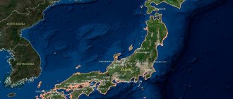
Since the territory in which the Japanese islands are located is part of the Pacific Ring of Fire, there are a huge number of both active and extinct fire-breathing mountains. If you look closely at the map of Honshu, you will find that on this island alone there are more than twenty volcanoes (half of them erupted in the past, and some even in this century).
As for Fuji, this mountain is located at the junction of several lithospheric plates: the Philippine, Eurasian and Okhotsk. It did not appear immediately: first Sen-Komitake was formed, and after its collapse - Komitake, but that did not last long.
Eighty thousand years ago, “Old Fuji” appeared in its place, which after 20 thousand years began to exhibit constant volcanic activity that lasted for ten centuries, and as a result the volcano was destroyed.
Instead, 11 thousand years ago, a young volcanic cone, “Young Fuji,” appeared, on the slopes of which more than a hundred lateral clefts subsequently formed . And some time later, the flows of basaltic lava erupted by it blocked the road to the rivers, the sources of which began in the north of Fuji, forming the Five Lakes of Fuji.