Waterways of varying widths and depths beautify a city, but create difficulties when there are too many of them. The area dotted with bodies of water is difficult to develop, and due to rainfall and melting snow, even small rivers quickly overflow their banks. And, of course, there will always be those who will turn a stream or river into a sewer in the middle of the city, pouring sewage into a convenient natural “trash can.”
The city authorities solved these problems by hiding the rivers in underground sewers. They were built in an open or closed way. The first was most often used in Moscow: a trench was dug next to the riverbed (or a natural ravine formed by the river was used), a collector was erected in it, water was redirected there, and the collector itself and the old riverbed were covered with earth. The closed method, in which tunnels are laid using mining shields, is rarely used. You can admire the red brick river sewers of the 19th century and see modern concrete ones in the photographs of diggers who are exploring the city's underground communications. We'll tell you about the most famous Moscow underground rivers (now you know where to look for them).
Neglinnaya
The Neglinnaya River flows in Moscow in the historical part of the city. Currently it is located entirely in an underground sewer. Previously, the river flowed near the Kremlin wall and not far from the Vodovzvodnaya Tower, then flowed into the Moscow River.
Currently, next to the large shopping mall in the Alexander Garden, you can observe an imitation of Neglinnaya over its historical bed. The real river runs much deeper.
Human settlements and shipping
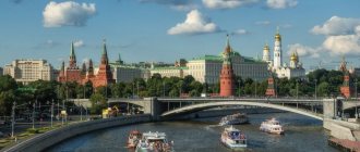
There are a number of settlements on the banks of the Moscow River. The main ones are Mozhaisk, Zvenigorod, Krasnogorsk, Dzerzhinsky, Zhukovsky, Voskresensk, Kolomna and, of course, Moscow. Within the capital, the length of the river is 80 kilometers. Here its width varies from 80 meters near the Kremlin to 200 meters near Luzhniki.
The Moscow River is navigable up to the Rublevskaya dam (210 km from the mouth). Both cargo and passenger transportation are carried out along its bed; cruises and boat trips are popular.
Historical reference
In 1401 the name of the river was “Neglimna”. There are versions that this name comes from the word “neglinko” (swamp), as well as from the Bulgarian word “glim” (depth), because in ancient times Baltic tribes lived on the territory of Moscow.
During a walk along the Moscow River on a motor ship, you can see that Neglinnaya gave names to many streets and squares of the capital. Trubnaya Square was named so because there was a hole in the wall of the White City through which Neglinnaya flowed.
Samotechnaya Street is named after the pond, which was the beginning of the Neglinnaya tributary (it was then called Samotek). Kuznetsky Bridge also owes its name to this river.
crustacean
We will continue the list of Moscow rivers with this river. It began near Maryina Roshcha, in a swampy area, then turned to the west at the Bird Tower near the wall of Kitay-Gorod. The crustacean flowed out of a nasty puddle, which today is called Chistye Prudy. Why does it have such an unusual name? In the Belarusian language, the river sounds like “crustacean”; it owes its name to this ancient word.
The crustacean was considered a dirty river; after floods, it resembled a large dirty puddle. Historians say that Rachka once flooded the Church of the Holy Trinity in Gryazekh. Then the river flowed near Ivanovskaya Gorka through Kulizhki, then crossed Vasilievsky Meadow, and flowed not far from the Belogorodskaya Wall into the Moscow River.
Nowadays, only Podkopaevsky Lane reminds us that the Rachka River once existed. Its unusual name is due to the fact that clay was mined in this place on the river, by digging up its banks for this purpose.
Pine
Cherkizovsky (Bishop) pond. Preobrazhenskoye district. Photo: Photobank Lori
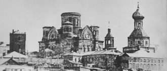
The village of Cherkizovo 1888. Edition by N. A. Naidenov. Photo: pastvu.com
Golyanovsky pond. Golyanovo district. Photo: Photobank Lori
Near the village of Kaloshino 1890-1917. Photo: pastvu.com
Sosenka stretches near Moscow for 8.8 kilometers. Once upon a time, pine trees grew along its banks - hence the name (the village of Chernitsyno, the villages of Golyanovo and Cherkizovo were also located here). Sosenka originates on the southern outskirts of the village of Vostochny outside the Moscow Ring Road. The river flows only in sewers, coming to the surface only at two ponds. South of Shchelkovskoye Highway it crosses the border between the city and the region, runs along Novosibirskaya Street and flows into Golyanovsky Pond. The second time it appears, flowing into the Cherkizovsky Pond, after which it crosses the Sokolnicheskaya metro line in the collector and merges with the Serebryanka River (together they form the Khapilovka River).
Sivka Creek
Considering the list of Moscow rivers, one cannot ignore this water source. The large stream originated at the site of the Patriarchal Pond, in the Goat Swamp, and flowed into Moscow near the Seven-Top Tower of the White City wall (next to the modern Cathedral of Christ the Savior). Sivtsev Vrazhek, on the Arbat, got its name from the stream. “Chertoroy” in translation means a water pothole, a ravine. Until 1658, Prechistenka Street was called Chertolskaya, but a lane with the same name still exists on the map of Moscow.
Presnya
The list of rivers in Moscow and the Moscow region would be incomplete without this reservoir. The river is mentioned in Ershov’s fairy tale “The Little Humpbacked Horse,” and it also appears in the works of Vladimir Mayakovsky. Thanks to the river, the Presnya district appeared in the capital.
It was on this river that the Humpbacked Bridge was located, which is associated with important historical events of the 20th century. This small river originated in the territory where the Timiryazevsky Forest Park is located, flowed towards the Moscow Zoo, and flowed near the Government House into the Moscow River.
Such small rivers of Moscow as Bubna and Kabanikha flowed into Presnya in the area of the Patriarch's Pond. The only ponds that remain from the Bubna River are Presnensky Ponds.
Short story
Since ancient times, the Moscow River has been a fairly important transport route, the waterways of which connected Moscow with Smolensk and Novgorod, with the Volga and Don rivers. Settlements of the Vyatichi (Eastern Slavs) appeared on the banks of the river in the last quarter of the 1st millennium AD (from the 8th century). Before the Slavs and for a long time together with them, Finno-Ugric and Baltic tribes lived in the river basin, after which they left a noticeable mark on the region.
The name of the river is ancient, and its origin is still somewhat controversial. There are many hypotheses of a possible Finno-Ugric, Slavic or Baltic source.
The rest of the article provides information about the mouth and where the Moscow River flows.
Yauza
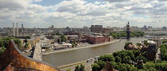
Considering the list of Moscow rivers, it is necessary to mention the Yauza River. It is considered the second largest in the capital and was mentioned back in 1156. Historians claim that its name has Baltic origins. Large trade routes were located near Yauza; it was along it that cargo from the south of Russia arrived in Vladimir.
Currently, the Yauza has been preserved without any major changes; there is also a beautiful embankment. In the Sokolniki area it is a navigable river. The river begins near the Losiny Ostrov national park, flows through Mytishchi, the north of the capital, crosses the Yaroslavl railway, and at the House on Kotelnicheskaya embankment it flows into the Moscow River.
Many small rivers flow into it, including underground reservoirs. Under the Yauza there are three large branches of the Moscow metro, as well as the Lefortovo tunnel. 2 open metro bridges, 22 road bridges, and 5 large railway bridges were built over the Yauza. Not everyone knows where the Yauza River flows in Moscow, although in size it is second only to the Moscow River.
Why were rivers hidden underground?
There are some reasons why Moscow's rivers currently flow underground.
Ecology
Once upon a time, underground rivers, still flowing in a free channel, were quite clean. They fished there, drank water, and used them for economic activities. But gradually, with the increase in population, they became polluted. Citizens dumped waste and sewage there. At some point, it became clear that these rivers were no longer suitable for drinking or even for swimming.
The unsatisfactory condition of Moscow rivers: Neglinnaya, Rachki, Sorochka, Nadprudnaya and Samotek - seriously threatened people's health. Fetid trenches flowed freely through the streets.
The sanitary and epidemiological danger became the reason for the construction of collectors for small watercourses in the capital.
Construction
Small rivers with swampy banks prevented the construction of buildings and the construction of roads and street passages. During floods and heavy rains, even streams caused floods, eroding the foundations of nearby objects.
To eliminate emergency situations, streams were filled up, and rivers began to be hidden in stone tunnels.
Moscow River
It begins in the Starkovsky swamp, which is on the Smolensk-Moscow Upland. In the old days, the source of this river was called the Moskvoretskaya Puddle. 16 kilometers from the source it passes through Lake Mikhalevskoye in the Smolensk region.
Walking along the Moscow River by boat is a favorite recreation option for Muscovites and guests of the capital. The river is navigable, the Pepervinskaya and Karamyshevskaya dams were built on it, and there is a system of locks.
It has always been considered the main transport route that connects the capital with the Don, Volga, Smolensk, and Novgorod. Previously, the river periodically overflowed, causing serious economic damage to the city. In order to cope with such a problem, the Vodootvodny Canal was built in 1783.
In total, about 70 different tributaries flow into the Moscow River, mostly hidden in special drainage pipes. There are many monasteries built along the banks, so during a boat trip around Moscow you can admire the domes of the Novodevichy, Danilov, and St. Andrew's monasteries. The quality of the water in it, unfortunately, leaves much to be desired. Due to the increased content of heavy metal cations, swimming in the river is prohibited. Instead, Muscovites like to ride along it on river boats in the summer.
How rivers are hidden underground
A natural source will always find its way to the surface, so simply filling it with sand or soil will not solve the problem.
There are two ways to transfer a river underground:
- open;
- closed.
Public method
In the 18th–19th centuries, an exclusively open method was used in the construction of tunnels. A trench was dug parallel to the riverbed and a canal was built in it. The current was redirected to a new highway, and the old channel was filled up.
In London in the 19th century, rivers that interfered with the construction of roads and structures began to be actively removed underground. The River Fleet is London's most famous underground river. There is even a term “London brickwork style”. From the point of view of hydrodynamics, and not from appearance, these collectors are very advanced and still function to this day.
In Vienna (late 19th century), a collector for the Vienna River of the same name was built using an open-cut method.
Engineering technology has changed little since ancient times. The process begins with preparing the base from crushed stone and gravel. The slab is laid on the compacted surface, taking into account the center and slope. If the installation is without flaws, then the block is lifted with a crane and the bottom is filled with cement mortar. The collector is lowered into place and the joints are sealed. The device is covered with hot bitumen and concrete rims.
The good thing about the open version is that the assembly is carried out in a continuous flow. Disadvantages include the need to block transport and pedestrian routes.
Private method
Closed technology does not involve laying trenches. In this case use:
- horizontal pushing of pipes using a special installation;
- adit construction method;
- panel version of the tunnel arrangement.
Trenchless excavation does not depend on terrain parameters and soil category. Can be used without restrictions.
Material
Brickwork has long been practiced in the construction of tunnels. Modern technologies use pipes made of durable concrete, and plastic is also replacing them.