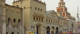
Leningradsky became the first station built in the capital; at first it was called Nikolaevsky. The station building in St. Petersburg bore the same name. The fact is that Emperor Nicholas I issued a decree on the start of construction of a railway between Moscow and St. Petersburg. After 1917, the Moscow station was renamed Oktyabrsky, and only later it received its modern name. The building was built in 1849.
Now the platform receives and dispatches trains heading to the northwestern and northern regions of the country, trains traveling abroad, and it also serves suburban routes. began traveling between the two capitals precisely from Moscow's Leningradsky station.
Leningradsky railway station is located at the Moscow-Oktyabrskaya station, and it is subordinate to the Oktyabrskaya railway division.
How to get to Leningradsky Station by metro
Leningradsky Station is located on Komsomolskaya Square, 3.
Nearest metro stations: Komsomolskaya (Circle line - brown - No. 5) Komsomolskaya radial (Sokolnicheskaya line - red - No. 1)
The Circle Metro Line connects all lines of the Moscow Metro, as well as seven of the nine railway stations in Moscow (except Rizhsky and Savelovsky), serving as a kind of interchange circuit. Therefore, the best way to get to the station is by metro.
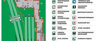
Map of Komsomolskaya metro stations at the end of the article.
Get directions to Leningradsky Station yourself
Features of construction
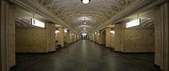
The station building was built in the mid-19th century according to the design of the architect Konstantin Ton. Exactly the same station was built in St. Petersburg, only a little larger in size. The interior decoration was luxurious: oak parquet, marble stoves, and there was a fireplace in the toilet rooms.
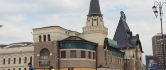
The first reconstruction of the station took place in 1934. Then they expanded the territory for ticket offices, equipped a mother and child room, and a telegraph and information desk appeared. Subsequently, alterations to the station premises took place many more times.
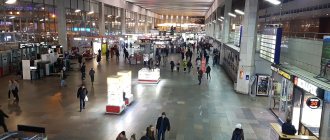
Now it is a modern station complex. There is everything you need for the comfort of departing and meeting people. As of 2016, 380 thousand people passed through the station building.
How to get from and to Leningradsky Station by public transport
Bus No. A - Luzhniki Stadium → Metro Komsomolskaya No. 40 - Krasny Put Plant → Metro Sokolniki No. 122 - Metro Lubyanka → Metro Sokolniki
Trolleybus No. 14 - Severyanin Platform → Elektrozavodsky Bridge No. 41 - Komsomolskaya Sq. → Ussuriyskaya
Tram No. 7 - Tverskaya Zastava → Metro Rokossovskogo Boulevard No. 13 - Kalanchevskaya → Children's sanatorium No. 37 - Kalanchevskaya → Novogireevo No. 50 - Kalanchevskaya → DC Compressor
Travel from other stations in Moscow
From Yaroslavsky railway station
Exit the Yaroslavsky station, turn right and enter the Leningradsky station building.
From Kazansky station
Go down from the Kazansky railway station into the underground passage under Komsomolskaya Square and go to the Leningradsky railway station.
From Kursky station
Go down from the Kursky station to the Kurskaya metro station and get to the Komsomolskaya station.
From Paveletsky station
Go down from the Paveletsky station to the Paveletskaya metro station and get to the Komsomolskaya station.
From Kievsky railway station
Go down from the Kievsky railway station to the Kyiv metro station and get to the Komsomolskaya station.
From Belorussky railway station
Go down from the Belorussky railway station to the Belorusskaya metro station and get to the Komsomolskaya station.
From Rizhsky station
Go down from the Rizhsky station to the Savelovskaya metro station. At the Prospekt Mira station, change from the Kaluzhsko-Rizhskaya line to the circle line. Get off at Komsomolskaya station.
Leningradsky station - Sheremetyevo how to get there
- Aeroexpress - Metro From Sheremetyevo Airport, take the high-speed Aeroexpress train to the Belorussky railway station. Aeroexpress high-speed trains run every 20-30 minutes. Travel time is 30-40 minutes. Next, go to the Belorusskaya metro station (Circle Line) and drive towards Novoslobodskaya to the Komsomolskaya station.
- Bus - metro From terminal D of Sheremetyevo Airport to the Rechnoy Vokzal Metro stop, take minibus No. 949 or bus No. 851. Then from the Rechnoy Vokzal metro station (Zamoskvoretskaya line) get to the Teatralnaya station. Go to the Okhotny Ryad station (Sokolnicheskaya line) and go to the Komsomolskaya station.
- Bus - metro From terminal D of Sheremetyevo Airport to the Planernaya Metro stop, take bus No. 817 or minibus No. 948. From the Planernaya metro station (Tagansko-Krasnopresnenskaya line) get to the Kuznetsky Most station. Go to the Lubyanka station (Sokolnicheskaya line) and get to the Komsomolskaya station.
Domodedovo - Paveletsky station how to get there
- Aeroexpress From Domodedovo Airport, take the high-speed Aeroexpress train to Paveletsky Station. Aeroexpress high-speed trains run every 30 minutes. Travel time is 40-50 minutes. The airport terminals have ticket machines that give change and also accept payments by bank cards. The railway platform from which Aeroexpress departs to Paveletsky Station is located next to the airport building, opposite the exit from the arrivals area.
- Bus - metro From Domodedovo Airport to the Domodedovskaya metro station, take bus No. 308. From the Domodedovskaya metro station (Zamoskvoretskaya line) get to the Paveletsky station.
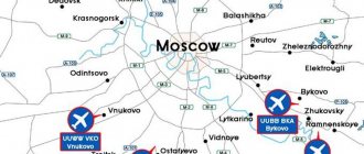
Leningradsky station - Vnukovo how to get there
- Aeroexpress - metro From Vnukovo airport, take the high-speed Aeroexpress train to Kievsky railway station. Aeroexpress high-speed trains run every hour. Travel time is 35 minutes. Go to the Kyiv metro station (Koltsevaya line) and go to the Komsomolskaya station.
- Bus - metro From the public transport stop “Vnukovo Airport” take bus number 911 to the “Salaryevo Metro” stop. From the Salaryevo metro station (Sokolnicheskaya line) get to the Komsomolskaya station.
Long distance train schedule
There are 10 tracks on the station platform. They are equally divided between long-distance and suburban trains.
About 65% of all passengers travel to the northern capital. Trains depart from the platform to Pskov, Murmansk, Petrozavodsk, Arkhangelsk and Novgorod.
International trains go to Tallinn and Helsinki. In addition to regular trains, branded trains depart from Leningradsky Station:
- Peregrine falcon;
- Nevsky Express;
- Red Arrow;
- Lev Tolstoy;
- Grand Express and others.
Suburban destinations are represented by trains to Tver, Konakovo, Kryukovo, Klin. In the summer season, passenger traffic increases significantly.
Leningradsky Station - Domodedovo Airport how to get there
- Aeroexpress - metro From Domodedovo Airport, take the high-speed Aeroexpress train to Paveletsky Station. Aeroexpress high-speed trains run every 30 minutes. Travel time is 40-50 minutes. Go to the Paveletskaya metro station (Circle line) and go to the Komsomolskaya station.
- Bus - metro - metro From Domodedovo Airport to the Domodedovskaya metro station, take bus No. 308. From the Domodedovskaya metro station (Zamoskvoretskaya line) get to the Paveletsky station. From the Paveletskaya metro station (Circle line) get to the Komsomolskaya metro station.
Additional service
For a comfortable wait for the departure or arrival of a train, the station has everything you need. In addition to a large number of comfortable chairs in the 2 waiting rooms, station visitors can take advantage of free WI-FI. Entrance to the toilet is free upon presentation of your ticket. There are ATMs from different banks inside. There is a children's corner in the waiting room for children.
The information board informs about the arrival and departure of trains.
There is a mother and child room. For one parent and a child under 3 years old, admission is free for 3 hours. You can also spend the night here, but the service is paid.
There are cafes and buffets in the main station building.
Other paid services include:
- Office services at the information desk (printing of documents);
- Paid parking;
- Luggage storage;
- Rest rooms and other services.
Moscow metro map - interactive diagram with time calculation
The Moscow Metro is historically the first and largest metro in Russia. This metro system is the fifth most heavily used metro system in the world. The first line opened in 1935 and bore the name of Kaganovich, and from 1955 it began to bear the name of Lenin.
Moscow metro stations have a rich history, and the stations of the Stalin period have rich decoration. Many of them are recognized as cultural heritage sites. For example, today many consider Mayakovskaya station the most beautiful, and during the Second World War there was a hospital there.
There are many legends associated with the Moscow metro. For example, the Revolution Square station is decorated with sculptures. And there is a belief that if a student rubs the nose of a dog near the sculpture “Border Guard with a Dog,” then he will have good luck in the exam.
Today the Moscow metro system consists of 14 lines. It is constantly evolving, with up to a dozen new stations appearing every year. And if you compare what the map/scheme of the Moscow metro was like at least 5 years ago and what it is like today, the difference will be very noticeable.
The government plans to build 53 more new stations by 2021.
In the fall of 2021, the 14th line opened - the Moscow Central Circle. Physically, this is a separate structure from the metro, operated by Russian Railways, but no additional fare is required when transferring from this line to others. At some stations the transfer takes very little time, while at others you need to walk a short distance along the street. When constructing a route, the Moscow metro map of our website takes into account the time required to move from line 14 to others. And despite the transfer not always being immediate, this ring allows you to move around the city much faster.
It is very easy to get confused in the metro map, especially for guests of Moscow. Our website was created to help you easily plan your route and get to your destination. We have a detailed metro plan.
There are about ten different maps of the Moscow metro on the Internet. We analyzed them all and realized that we could make ours more convenient and informative.
An interactive diagram/map of the Moscow metro lays out the route and highlights it on the map, and also determines the travel time and the number of transfers. Left-click on two stations in succession, and our website will show you the route, as well as an approximate travel time estimate. If you find it difficult to find a station on the map, use the panel at the top of the screen: start entering the name of the station in the “From” and “To” fields, select the necessary stations from the list that appears, and they will be marked on the map along with the route.