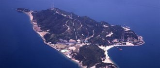
The territory of Japan is located on 6,800 islands of a stratovolcanic archipelago in the Pacific Ocean, its area is 377.9 thousand km². China and Taiwan in the northeast are separated from the Japanese coast by the East China Sea, Korea in the east by the Sea of Japan, and to the north of Japan lies the territory of the Russian Federation.
Relief of Japan
The coastline of Japan is highly rugged; there are a large number of bays and sea bays. A characteristic feature of the local terrain is the predominance of mountains, constituting 71% of the entire territory of the country. The number of plains and lowlands is small; these are small coastal areas near the sea or in river valleys, bordered by mountain peaks.
(Detailed relief map of Japan)
The relief of Japan is the result of mountain building processes that continue to this day in the seismically unstable Pacific geosynclinal region. Every year thousands of earthquakes of varying amplitude are recorded here; if an earthquake occurs at the bottom of the sea or ocean, the danger of huge tidal waves and tsunamis rising increases; their destructive power can cause significant harm to both people and their property.
How Fuji got its name
The etymology of the name Fuji still remains unknown. In Japan, Fujisan symbolizes antiquity; the mountain was sacred to both monks and ordinary citizens. Supposedly, Fuji literally translates to “immortality.” This is confirmed by one of the sources dating back to the 10th century AD. Records survive dating back centuries to the Edo Dynasty. According to them, the name of the mountain comes from an ear of rice and is associated with slimness.
There is an opinion that Fuji received its name thanks to the Ainu people who once lived here. This name can be associated with fire. However, a number of linguists refutes this version, believing that the name can be associated with a rainbow.
The majestic beauty of Japan's highest mountain
Modern Chinese characters, which are used in the current writing of the Japanese and appear in the name of the mountain, are associated with wealth and nobility. However, their semantic load is small, since they can rather be classified as additional words.
The main version suggesting that Fuji means “immortality” comes from the tale of the old man Taketori. However, folk etymology claims that the name is directly related to the word “incomparable.” There is also a claim that the etymology goes back to the word “inexhaustible.” The version about the connection of the name with the spikelet was created by the scientist Hirata Atsutane.
The association of the name Mount Fuji with fire came from the missionary John Botchelor. However, Japanese linguists refute this version, citing phonetic development. The connection with the wisteria tree was found by toponymist Kanji Kagami. He also suggested that a parallel could be drawn with the word rainbow. The phrase “Mount Fuji” is redundant, but this is how Western sources prefer to write it. The Japanese themselves consider this kind of reading to be incorrect. There are many spellings of the name of the volcano, but they are used only in poetry. For example, Fuyo-ho means "lotus peak", most likely due to Fujiyama's association with the lotus flower. The name Fugaku is also found, which suggests that Fuji is a proper name.
Mountains and volcanoes of Japan
Mountain peaks are characterized by medium and low heights; they are often elongated in the meridional direction, sometimes they have a labyrinthine shape (the mountains of Kyushu Island). One of the most significant Japanese mountain systems, the Japanese Alps (so called by Walter Westen, an English missionary who preached Christianity to the Japanese), are located in the central part of the island of Honshu. These are three ridges parallel to each other, up to 3 thousand meters high, separated by deep gorges and glacier platforms.
Geological characteristics
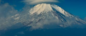
The origins of Fuji , whose topography has been affected by volcanic activity, are unknown. According to folk tradition, the mountain was formed after an earthquake in 286 BC. Volcanologists believe that the current volcano is the result of four separate phases of volcanic activity that characterize its shape and structure. The regular conical shape of the mountain is the result of the overlapping layers of hardened lava and volcanic ash.
The main crater of Mount Fuji is located on a fault that is part of the Pacific Rim, between the Eurasian Plate, the Okhotsk Plate and the Philippine Plate. Although the main phase of Fuji's volcanic activity occurred 11-8 thousand years ago, the volcano is not considered extinct. Since 781 there have been 10 eruptions, including three significant ones. The last eruption occurred from October 28, 1707 to January 1, 1708. It was accompanied by a strong earthquake on October 28, 1707.
A consequence of volcanic activity and the stratification of the structure of the Fuji volcano, there are 150 solidified lava flows, among which the largest are the Mishima and Mano flows. These flows have created numerous natural caves with lava rocks along the slopes of the mountain.
In addition to the caves, you can also observe the characteristic “lava trees” (lava coating around a tree trunk left by a lava flow).
The surface of the mountain is covered with valleys and gorges formed by the corrosion of wind, water and snow over the centuries. The largest and most extensive of these gorges, goes to the western side of the peak at an altitude of about 2200 m. The gorge is 2 km long with a width of 500 m, and a depth of 150 m.
Japan's highest mountain peak
Fujiyama
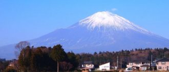
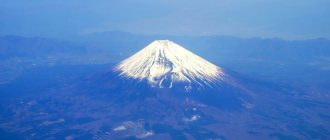
The highest point in Japan and the world famous Japanese mountain is the active stratovolcano Fuji (3776 m) on the island of Honshu, 90 km southwest of the capital of Japan - Tokyo, part of the Japanese Alps system. At this time, it exhibits weak activity; the last volcanic activity was recorded here at the beginning of the 18th century.
The volcano has a classic cone-shaped shape; for Buddhists and Shintoists it is an object of religious worship, for guests of the country it is an object of admiration, for Alipinists it is an object of conquest. The indigenous people affectionately call it “Fuji”; it is a bright symbol of the country, along with sakura and origami, glorified in Japanese art for hundreds of years.
Mount Zao
| Cable car on Mount Zao. Are you brave enough to ride it? |
No matter what you are looking for, be it great hot springs, active winter outdoor recreation, snow-covered trees that look like some kind of monster, scenic mountainous terrain, autumn leaves or a tourist adventure, you will find it all at Mount Zao . True, in order to be amazed by the beauty of the snow-covered expanses, to be afraid of monsters or to devote time to winter sports, you will still have to go at another time of the year. For now, we are interested in autumn - especially the magnificent autumn landscapes on the slopes of Mount Zao. By the way, unlike admiring the falling leaves, the opportunity to visit hot springs is relevant throughout the year. Mount Zao is a special place that can give you the best vacation.
| Okama Crater Lake on Mount Zao. Amazing color! | Source: Tomoaki INABA |
It is located on the border between Yamagata and Miyagi prefectures in Tohoku Prefecture. A volcanic mountain range like this will not only make you feel proud to have conquered its hiking trails, but also offer incredible natural wonders like the Okama Crater, where an incredibly beautiful lake was formed.
Would you like to admire the brilliant colors of the local autumn landscapes? If so, head to Zao Onsen where you'll be boarded on the Zao Ropeway for stunning views of the area. Autumn colors will win your heart. To enjoy them, you don’t have to be an experienced tourist or a mountain fan; you just need to rely on the cable car, which will give you all the best viewpoints. The most recommended place to visit Mount Zao is mid-October.
Mountain ranges and volcanic peaks
Most of the Japanese peaks are extinct or active volcanoes (there are about 200 of them, of which 67 are classified as “living”, i.e. active or dormant). The most active volcanoes in Japan are Asosan (more than 70 eruptions have been recorded, its crater is one of the largest in the world), Miharayama, Asama, Sakurajima.
Hida
The northern mountain range of the Japanese Alps, its length is 140 km, the mountain peaks reach an altitude of more than 3100 meters, the highest peaks of the range are Mount Tayatema, 3015 meters high, and Hotaka Mountain Peak, 3190 m.
Kiso
A chain of mountain ranges 150 km long in the central part of the island of Honshu as part of the Japanese Alps (central ridge). Consisting of granite rocks, its highest point is Mount Komagatake (2956 m). The foothills of the mountains are covered with dense coniferous forests; a high degree of dissection of the steep slopes by the valleys of the Kiso and Tenryu rivers is noticeable.
Akaishi
The southern range of the Japanese Alps, located in the central part of the island of Honshu, includes the territories of Nagano, Yamanashi and Shizuoka prefectures. The highest point is Mount Quito, 3193 m high.
Daisetsuzan
A mountain range stretching for 100 km in the center of the island of Hokkaido, the highest point is the extinct volcano Asahidake (2290 m). It is based on granite, quartzite, sandstone and shale. Within its borders there is a National Park of the same name.
Kitakami
The mountain range is about 200 km long and 60 km wide, located in the northeastern part of the island of Honshu, the highest peak is Mount Hayatine.
OU
This is the main watershed ridge in the northern part of the island of Honshu, 400 km long, the highest point is the Iwate volcano.
Echigo
A mountain range in the northwestern part of Honshu, bordered in the southeast by the Echigo Plain, length - 170 km, the highest peak is the Kusatsu-Shirane volcano (2171 m).
How beautiful you are, Japanese mountains. Mount Nantai
Japanese mountains are one of the interesting topics, since there are a large number of them in Japan. The bulk of the mountains are volcanoes, often active. Mount Nantai (男体山), located in Nikko National Park, is one of the list of mountains recommended for visiting by the Japanese. Its height above sea level is 2486 kilometers. According to the book written by the Japanese writer and mountaineer Kyuya Fukado, Mount Nantai is included in the list of 100 famous mountains in Japan. In his list, Fukado-san included mountains based on the criteria of historical value, grace and individuality, and the height of the mountains varied from 1500 meters and above above sea level. Crown Prince Naruhito was inspired by the book and thought about climbing to the top of each of the mountains. The 1980s saw a boom in climbing throughout Japan.
Mount Nantai literally translates as mountain of the male body and is a stratovolcano, another name is Futara Volcano. According to research, the volcano erupted 7,000 years ago. And accordingly, scientists believe that the mountain should be classified as an active volcano and plans should be developed to prevent natural disasters. Settlements are located near the mountain and the mountain itself is a tourist destination.
Theoretically, it was planned that having climbed to the top of the mountain, a picturesque view of Lake Chuzenji and the Senjogahara plateau would open in front of us. And the goal was to reach the top of Nantai, visit the Futarasan shrine and see the symbol of imperial power, the sword Kusanagi no Tsurugi (though I did not find information about what this sword has to do with Mount Nantai, knowledgeable people, please respond and enlighten me).
To be honest, when I chose the tour, I did not plan to climb the mountain, but then I hoped that the climb would not be difficult and that the attentive Japanese had made a convenient path and stairs to make it easier for tourists to visit the sanctuary. In reality, everything turned out to be not so rosy.
Despite the fact that already in the evening it was clear that we would not see any picturesque views, the upcoming ascent was complicated by incessant rain, nevertheless, waking up at five o’clock we got ready to hit the road.
The estimated time, as everyone writes, is 4 hours to the top of the mountain and 2 hours back. Well, yes, perhaps if you have climbed Elbrus and other smaller mountains, you will reach the top in 4 hours.
This time is designed for young and resilient people. Our further tour was also calculated from this ideal time. Even when in the evening we talked with the manager of the ryokan and said that we were going to Nantai, he looked at us so meaningfully, as if he respected us, or maybe doubted us. Nevertheless, we agreed that we would return by 12 o’clock (and since we need to check out of the room at 10.00, our things would be taken out and they would wait at the reception) and he said that upon our return we could take a shower and onsen. He understood what he was talking about, I still didn’t understand...
By six in the morning we were already at Futarasan Temple and bought tickets. Entry costs 500 yen. They told us and showed us the route, gave us amulets for the road and wished us a safe journey. In the morning there was absolutely no time to take photos, upon my return I took a photo and here it is.
After standing at the altar, we thought that we should throw a coin and ask for help from the kami (gods in Shinto), but we didn’t do this, but hurried on. Perhaps if I cupped my hands and made a wish, I would have additional strength? Now I don't recognize it.
Immediately behind the temple, steep stone steps began, which soon ended and the path up the mountain continued through the torii.
The guys somehow quickly rushed forward and I thought that I should probably complete my “climbing”, but they quickly realized that I was not a conqueror of peaks and slowed down the pace a little. Alexey, who lives in Japan and was our guide for a couple of days, offered me his trekking poles. I didn’t even imagine that they could make it so easy not only to climb, but also to descend. Thank you very much, Alexey!
Expecting that it would be cold at the top, I properly wore thermal underwear and a sweater. We had not walked even 300-400 meters and I began to undress, otherwise I would have simply exploded. The first part of the path is an earthen, steep path, sometimes dotted with numerous tree roots. Considering that it was dripping from above, the ground was slippery and walking was, of course, difficult.
The guys were still trying to talk, but I diligently walked forward, remained silent and conserved my strength. Forward is a strong word, I just silently climbed behind the guys and thought “why do I need this peak?” There won't be any good photos because it was gray and foggy around. I can’t say that I’m a mountain lover. When I was young, yes, I liked it, but for all my time. And our deadline, of course, was a little stressful.
And then, lo and behold, we came out onto an asphalt road, along which only official vehicles traveled somewhere far up the mountain. We walked along the road for about 20 minutes, during which time our breathing was restored and our strength gradually began to return. I also joined the conversation, now there was no fear of losing my breath.
So imperceptibly we reached the third level.
Further, stones and boulders began to appear more and more often, I climbed more and more slowly and the guys stopped more often to wait for me.
I read on Wikipedia the following phrase: “the climb up the mountain is carried out along a stone staircase with steep steps and takes a lot of time.” Of course there were a couple of stairs, a couple of dozen steps like in the picture above, but starting from the middle of the path it began to look like this:
Further on there are more stones, less forest and a steeper climb and this is called “along the stone stairs”? On the way up there was no time for photography at all; on the way back, having walked most of the way, I suddenly came to my senses and realized that now I had a minute for photography, so a lot was left behind the scenes.
But for now we continued to persistently move forward. The allocated 4 hours for the climb have already ended, and we have only reached level 7. I started to worry about myself, about time, and about the guys, that I was slowing them down. But Alexey encouragingly said that we shouldn’t think about the top, but rather think about the next step. And that we will continue our journey together. The thought of having to return made me feel uneasy. We joked about the helicopter. Alexey said that he would have to pay several million yen for evacuation by helicopter. I climbed further, the stones became very large. I already knew that I wouldn’t go to the top, but for some reason I went up. I was soaked through, realizing that if I stopped, I would immediately freeze.
So we reached the eighth level, I decided that I would return. The guys started talking about getting up again, I understood that they were worried that they would leave me alone. I promised that I would wait for them here, but I understood that I would not wait, since closer to the top it became colder and windier. The guys also understood this. We agreed that if I wasn’t here, then I would leave... We drank coffee and chocolate and here we saw a cheerful Japanese man who was already returning back. He told us that it was still an hour's walk to the top. In terms of time, he left at about the same time as us, but somehow we were late...
Alexey handed me back his poles (what would I do without them, I would sit on one of the high stones and wait for someone to take me down) and we went our separate ways.
If there were no time limit, I would have reached the top in my relaxed rhythm, but when you go in a group you have to adapt to it, they adjusted to me too, but that’s what was stressful, I tried my best, but I couldn’t keep up the rhythm .
And only when I began to descend did I realize how high we had climbed. The road seemed endless, it seemed that we went up from the seventh to the eighth level faster than I went down. Here another group of muscles started to hurt and oh my poor knees. The descent is also very difficult, but I walked alone and could choose the pace I needed. Going lower, I remembered my camera and took a few pictures.
While I was walking down, the guys reached the top of the mountain and captured the views of Nantai, they say it was not easy to get there. Photos from the summit by Dmitry Tselishchev.
I went down for about 3 hours, slowly admiring the nature and fresh air. Somewhere in the middle of the mountain I met a briskly walking couple of middle-aged Japanese, I think about sixty years old, with large backpacks on their shoulders. And once again I thought that the Japanese are a hardy, trained people. Their life consists, among other things, of such pilgrimage ascents to sanctuaries, we said hello and everyone went their own way. On the way I met two more groups of young people. On this day, not many people rushed to the top of Nantai.
It was very pleasant to note that particularly difficult sections of the path were “improved”, sandbags were stacked somewhere to make some kind of steps, in places where it is almost impossible for one to climb or descend, ropes and all sorts of other little things were tied for convenience.
The last steps were the most difficult, I left my water there at the top and wanted to quickly get to the water dispenser, but there were still relics on the way that we didn’t photograph at first and I, torn between fatigue and curiosity, photographed and photographed everything. This was my first acquaintance with the Japanese mountains. To make it happen again you need to practice a little, but that will be another story...
Before returning back and entering the official territory of the temple again, there was a special fountain with brushes and all the bells and whistles to get yourself (or rather, your shoes) in order after a long journey, and this was by the way, I felt a little piggy - dirty, wet, sweaty .
Finally, I took another photo of the temple and we headed to the ryokan.
Instead of the planned 6 hours, we walked through the mountains for 9 hours and returned to the hotel at three o’clock. We took a shower, without it it would have been hard, and we were fed our missed breakfast. If it really was breakfast, then it looked like a full lunch and we went further, on the way we stopped at the 97-meter Kegon waterfall, but because of the fog it was not visible at all and only the sound of water was heard.
Ahead was the path along the Japanese romantic road to Minakami, where we were to spend the evening and morning at Takaragawa Onsen.
For information, Mount Nantai is open to the public from May 5th to October 25th. The mountain, like the territory of Nikko itself, is a place where pilgrims come to honor the deity of the Futarasan Temple.
The Night Climbing Festival is held from late July to mid-August. The result of the climb is admiring the sunrise at the top of the mountain.
Friends, there are still many stories about the sights of Japan ahead; I am not quickly, but consistently, mentally retracing my path, my first personal acquaintance with Japan. It was an exciting and educational journey. I would be glad if you share your thoughts, and perhaps stories. Until next time.
PS
Many thanks to Olga for interesting and informative comments and beautiful photographs. It's always interesting to listen to eyewitness accounts. Every year, and perhaps every month, there are fewer and fewer places in Japan where Olya has not set foot; she is constantly on the move, on the way to new beautiful and historical places in Japan.
Explanation for the photos in the comments.
View of the lake from Mount Syazan
Similar articles
- The relief of Japan and its features Ridge
is considered axial.
... In Japan
there are few of the usual gentle slopes into the plains; more often
the mountain
breaks off and a lowland begins. Read more - Fuji sacred mountain of Japan myths and legends
One of the symbols of the Land of the Rising Sun is Fuji, the sacred
mountain of Japan
. This is a volcano considered “young”. Read more - The symbol of Japan is Mount Fuji
One of the most visited and hard-to-reach places
in Japan
is
Mount
Fuji. This is an unextinguished volcano, at the same time, the calling card of the Land of the Rising Sun. Read more
Plain lowlands
The share of plains and lowlands in the country's topography is about 25% of the territory. These are small low-lying areas along sea coasts and in river valleys. Their width can be from several tens of kilometers to 150-160 km (like the Tokyo Lowland). There are 7 Japanese plains, differing from each other in area: Kanto or Tokyo Lowland, Ishikari, Echigo, Nobi, Kitakami, Setshu and Tsukyushi.
Kanto
The largest of all the lowland plains of Japan, it covers an area of 13 thousand km2. Located in the vicinity of Tokyo, on the east coast of the island of Honshu. This is a tectonic depression, filled with sea and river alluvium, with layers of volcanic ash. Suitable for agricultural use, the lands of the plain are intensively cultivated.
Ishikari
It is located in the western part of the island of Hokkaido, in the coastal areas of the Sea of Japan, with an area of 3.8 thousand km2. It is composed of alluvial deposits of the Ishikari River and its tributaries. There are many swamps on its territory; large deposits of coal are located here.
Echigo
The area is 2 thousand km2, located over 150 km on the western coast of northern Honshu, at the mouth of the Shinano River. It is based on a layer of river alluvium from the Shinano River and marine sediments.
Noby
The lowland is located on the Pacific coast of the island of Honshu, near Nagoya, with an area of 1.8 thousand km2. It is composed of alluvial sediments of the Kiso River and marine sediments.
Kitakami
Located north of the city of Sendai on the Pacific coast of the northern part of Honshu, it has an area of 1.2 thousand km2.
Setshu
A lowland near the city of Osaka, off the eastern coast of Honshu, washed by the inland Sea of Japan, area 1.24 thousand km2.
Mount Fuji: Kawaguchiko Fifth Station
| Fifth Autumn Mount Fuji Station: Kawaguchiko | Source: japan-guide.com |
And here, finally, is the last (in order, but definitely not least!) mountain that can be visited in the autumn season. This is the fifth station of Kawaguchiko or the fifth station of the Fuji Subaru Line. It is located in the middle of the Yoshida Route, one of the most popular hiking trails for conquering Mount Fuji. There are many karamatsu - or, in other words, Japanese thin-scaled larches - that grow in incredible autumn colors. You can definitely enjoy them if you head to the fifth station, because with the arrival of autumn, these colorful colors literally take over the rocky slopes of Mount Fuji near the fifth station of Kawaguchiko.
The yellow-golden leaves reach the peak of their beauty and richness at the end of October each year. Slowly and carefully climb the hiking trail, looking for the best spots to photograph the surrounding landscapes and autumn valleys below. Mount Fuji can rightfully be called the most beautiful mountain in Japan, and therefore, if you don’t go to Fuji during your autumn trip, you’ll be missing out on a lot.
| In autumn, the slopes of the Japanese mountains are truly magical! | Source: Takuma Kimura |
All these mountains are scattered across very different regions throughout the country. If you take a trip to any popular mountain tourism destination, you will not only get acquainted with rare sights and experience a sea of emotions, but also plunge into the lifestyle of mountain settlers. Their amazing cultural traditions and the splendor of the surrounding nature will inspire you for life.
visa to Japan for Ukraine, Kazakhstan and Belarus | excursions in Japan | tours to Japan
Fuji and religion
The mountain is considered a cult place for all religious people who have chosen Shintoism. According to their beliefs, gods live here. It is believed that the god Ainu, personifying fire, built a forge on the top. The very top is guarded by the goddess Sengen, who will throw off anyone who dares to encroach on the shrine.
The image of Mount Fuji has always been associated with Shintoism
The road to Fujisan is open only to the right person. The god Konohana flies on a snow-white cloud directly above Fuji. Shintoists associate Fuji with marital fidelity. Pilgrims come here every year. Moreover, they have a funny saying that a person who has never climbed Mount Fuji is a fool. But if he climbed twice, it means he is a fool twice. This saying was born out of a high sense of beauty. You can appreciate all the beauty only the first time; the second time it no longer makes sense. The paradox of conquering Fuji is that it became accessible to women only in 1912, although the spirit of the mountain has always been associated with the female gender.
Climbing Mount Fuji: routes
Fujisan became famous far beyond Japan. People come here for various reasons. For example, some people simply take photographs, others paint pictures, and others go for inspiration. But there are always many climbers trying to conquer Fuji. The best time for climbing is mid-summer. During this period, rescue centers and mountain huts are opened. Here you can not only take a nap, but also buy food and drinks. This will definitely come in handy for every traveler, because climbing the mountain with a heavy backpack will not be easy. It is much better to replenish supplies while moving towards the top.
Crowds of people climb Mount Fuji
In addition, from mid to late summer it is relatively safe here. Already in autumn, snow begins to cover the top, and the layer can be very thick, so travelers are not recommended to tempt fate. Many routes are closed during snowfalls.
The mountain is conventionally divided into 10 levels, starting from 5 there are 4 routes. You can get to level 5 directly along the toll road, which starts from Lake Kawaguchiko. On the side of the lake there is a route along the territory of which mountain huts are distributed. The main number of trails falls on it. Even an unprepared traveler in good physical shape can cope with the route, but the journey can last as long as 8 hours, not counting rest. The descent is faster and takes about 5 hours.
Not only people climb Mount Fuji, but also bulldozers. Separate routes are provided for them. With their help, goods are delivered to the mountain, which are then sold in mountain huts. They can also quickly evacuate people. You cannot walk on such roads, as this poses a serious danger: the stones are not reinforced, they may begin to crumble. Nevertheless, there are reckless people on bicycles who often travel along such routes. One should not follow their example, because the steepness is very high, and stones bouncing off the wheels pose a threat to climbers who choose neighboring routes that lie next to the routes for bulldozers. It is noteworthy that about 30% of those visiting Fuji are foreigners.