Water resources, presence of rivers, lakes
The hydrographic network of the Tambov region is represented by rivers, lakes, swamps, ponds and reservoirs. The rivers of the Tambov region are located in the basins of two rivers: the Volga and the Don. In total, 1,400 rivers and streams flow through the region, 1,200 of which are less than 10 km long. The total length of all rivers in the Tambov region is 6800 km. Drainage area of the river basin The Don is 20.1 thousand km2, river. Volga 14.2 thousand km2. The main (70.3%) river flow occurs in the spring. According to the existing classification, there are no large rivers in the region, only small and medium ones.
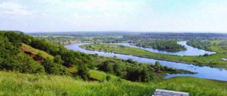
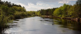
River Tsna. Third-order tributary, river basin Volga. The total length of the river is 446 km, of which more than 300 km flows through the Tambov region. The river originates in the southwest of the region, flows north and goes into the territory of the Ryazan region.
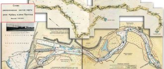
Karachan River. Second-order tributary, Don River basin. The river originates in the Tambov region and goes to the Voronezh region. The total length of the river is 95 km, of which km in the Tambov region, 75 km in the Voronezh region. Vorona River Second-order tributary, Don River basin. It starts in the Penza region, flows in the Tambov region and goes to the Voronezh region. The length of the river is 454 km, of which 216 km is in the Tambov region.
Savala River (border of Tambov region and Voronezh region). Second-order tributary, Don River basin. The length of the river is 285 km, of which 119 km are within the Tambov region, the rest of the river is located on the territory of the Voronezh region.
Bityug River. First order tributary, left tributary of the Don River. The length of the river is 379 km. In the Tambov region, the length of the river is 99 km. It flows from east to west and goes into the territory of the Voronezh region.
Voronezh River. First order tributary, left tributary of the Don River. Within the Tambov region, the length of the river is 22 km. The river flows from east to west and goes into the territory of the Lipetsk region.
Matyra River. Second-order tributary, Don River basin. The length of the river is 180 km. The length of the river within the Tambov region is 120 km. It originates within the Tambov region and goes to the territory of the Lipetsk region.
According to average long-term observations, spring floods on the rivers of the region begin in the south in the third ten days of March, and in the north – in the first ten days of April. The water level rises by 4-6 m in 10-15 days. The volume of runoff from the territory of the region of 75% supply is 4.1 km3, 95% - 1.49 km3. The forecast operational resources of groundwater in the Tambov region are 717 million m3 per year.
Lakes.
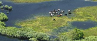
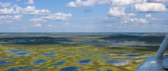
There are about 300 lakes on the territory of the Tambov region, with a total area of 88.6 km2. The lakes are small in size and are located on floodplains, occasionally on river terraces and watersheds. Large floodplain lakes are located in the river valley. Crows.
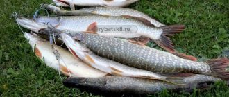
Lake Ramza is the largest in the Tambov region (area 250 hectares, depth up to 2 m, about 60 years ago it was more than 4 m). The bottom of the lake is covered with a layer of black, greasy silt (sapropel) with the smell of hydrogen sulfide. In 1990, white swans, water hens, and several species of ducks settled on Ramza. The lake is rich in fish. Below are the fish-rich lakes Kipets, Ilmen, and Semerka. At the bottom of Lake Ilmen there are 40-50 thousand tons of sapropel. Smaller lakes are oxbow lakes on the river. Vorona is Prorva, Lebyazhye, Zverinoye, Kurganskoe, etc. In the river valley. Tsna also has small lakes: Knyazhevo, Chistoe, Orekhovoe, Krutoe, Tyoploe, etc. Some of the Tsna lakes became shallow, and they turned into swamps. Some lakes are quite deep and drain into the river. Tsnu. Thus, Lake Svyatovskoye near the city of Tambov has a depth of 12-13 m. On the terraces of Tsna, lakes Chistoe, Krugloye, Berezovoye, Karasevo stretch out in a chain. Lake Chistoe has been declared a natural monument.
Ponds and reservoirs.
In addition to natural surface water bodies, there are 880 ponds and reservoirs in the region. with a total water reserve at NPL of 530 million m3. More than 560 of them are located in the territory belonging to the river basin. Don, and 320 water bodies with a total water reserve of 227.2 million m3 are located in the Volga River basin. The largest reservoirs include: Tambov on the river. Lesnoy Tambov, Shushpanskoye, Chelnavskoye, Kershinskoye, Yaroslavskoye. To artificial water bodies that partially regulate river flow. Tsna also includes 10 waterworks of the Tsna lock system, eight of which are located in the region and serve to supply water to industrial enterprises in the cities of Tambov and Morshansk, irrigate land and create a favorable water-air regime for floodplain agricultural land. The total volume of water regulated by hydraulic structures is 97.5 million m3.
Tambov Region
Tambov region is a subject of the Federation in the European part of Russia. The region is located in the center of the East European Plain, occupies the central part of the Oka-Don lowland, the eastern part extends onto the slopes of the Volga Upland. The relief is characterized by flat surfaces of watersheds, which alternate with wide forest valleys, and developed ravines and ravines.
The Tambov region is part of the Central Federal District. The administrative center is Tambov.
The region's territory is 34,462 km2, the population (as of January 1, 2017) is 1,040,327 people.
Surface water resources
The watershed between the Black Sea-Azov and Caspian basins passes through the Tambov region - the region’s water bodies belong to the Volga and Don basins (43% and 57% of the territory, respectively).
The river network of the Tambov region is represented by 1,398 rivers with a total length of 9,110 km (the density of the river network is 0.26 km/km2), most of which are small rivers and streams. The region's rivers are flat in nature, have low slopes, low flow speeds, and the river floodplains are often swampy. The rivers of the Tambov region are characterized by mixed nutrition with a predominance of snow (60–70%). The rivers of the region belong to the Eastern European type of water regime, they are characterized by high spring floods, summer-autumn low water, interrupted by rain floods, and low winter low water. They freeze in late November - early December, open in mid - late March. The largest rivers of the region in the Don basin are the Khoper with its tributary Vorona and the Voronezh River, in the Volga basin - the Tsna (tributary of the Moksha). The full flow of the Tsna River in the interests of local navigation is supported by the hydraulic structures of the Tsna lock system.
The average long-term river flow is 4.1 km3/year. In 2015, river flow in the Tambov region amounted to 3.2 km3/year, which is 21.95% lower than the long-term average (the smallest negative deviation among the regions of the federal district). Below is the dynamics of river flow in the Tambov region from 2010 to 2015.
According to the Institute of Lake Science of the Russian Academy of Sciences, in the Tambov region there are more than 2,900 lakes and artificial reservoirs with a total area of about 190 km2 (lake content 0.54%), including about 120 lakes with an area of more than 0.01 km2 and a number of smaller lakes. Most of the lakes are floodplain, located in the floodplains of Vorona, Voronezh and Tsna. There are several glacial lakes in the northeast. The largest lakes in the Tambov region are Ramza, Ilmen and Kipets in the floodplain of the river. Crows have an area of 2.16, 1.65 and 1.08 km2, respectively. Artificial reservoirs are much larger than natural ones; the largest of them are the Tambov (Kotovskoe) reservoir on the river. Lesnoy Tambov (right tributary of the Tsna) and Shushpansokoye reservoir on the river. Shushpanke (left tributary of Lesnoy Voronezh).
Swamps and wetlands occupy 1.27% of the territory of the Tambov region - 439 km2.
The area and number of lakes and artificial reservoirs, swamps and wetlands are variable; they depend on natural (water regime, climatic phenomena, swamping, meandering, etc.) and anthropogenic (drainage of territories, flow regulation, etc.) factors.
Groundwater resources
The forecast groundwater resources of the Tambov region are 6192 thousand m3/day (8.36% of the total volume of forecast groundwater resources in the Central Federal District and 0.71% in Russia). Groundwater reserves in the region as of January 1, 2015 amounted to 925.8 thousand m3/day, which corresponds to a degree of knowledge of 14.95%.
According to data as of January 1, 2015, 232.2 thousand m3/day were produced and extracted from groundwater bodies in the Tambov region during the year, including 151.2 thousand m3/day in the fields. The degree of development of groundwater reserves is 16.33%.
Provision of population with water resources (according to 2015 data)
The provision of the population of the region with river flow resources is 3.047 thousand m3/year per person, which is significantly lower than the Russian average (31.717 thousand m3/year per person), but higher than the indicator of the Central Federal District (2.082 thousand m3/year per person).
The provision of predicted groundwater resources is 5.895 m3/day per person, which is comparable to the Russian average (5.94 m3/day per person) and higher than the figure for the Federal District (1.894 m3/day per person). According to this indicator, the Tambov region ranks third among the regions of the federal district after the Smolensk and Tver regions.
Below is the dynamics of provision of the population of the Tambov region with river flow resources in 2010–2015.
Water use (as of 2015)
The intake of water resources from all types of natural sources in the Tambov region is 103.02 million m3, most of the resources are taken from underground water sources - 79.29%, the share of intake from surface water sources is 20.71%. Below is the dynamics of fresh water intake in the Tambov region in 2010–2015.
The total water losses during transportation in the Tambov region are 9.98 million m3 or 9.69% of taken water, which is higher than the federal district (5.39%), but lower than the Russian average (11.02%). Below is the dynamics of water losses during transportation in the Tambov region in 2010–2015.
Direct-flow water consumption – 93.04 million m3. Most of the water was used for drinking and domestic purposes, as well as for industrial needs (<59.11% and 27.52%, respectively), with agricultural water supply and irrigation accounting for 5.16% and 2.58%, respectively. Below is the dynamics of water consumption in the Tambov region in 2010–2015.
Domestic water consumption per capita in the Tambov region is 52.366 m3/year per person, which is lower than both the Russian average and the federal district indicator (56.205 and 59.952 m3/year per person, respectively). Below is the dynamics of domestic water consumption per capita in the region in 2010–2015.
The volume of circulating and re-sequential water consumption in the region is 223.44 million m3 or 70.6% of the total water consumption in the region. Below is the dynamics of direct-flow and recycling and re-sequential water consumption in the region in 2010–2015.
Discharge of wastewater into water bodies of the Tambov region is 54 million m3, of which 23.39% is conditionally pure and standardly treated wastewater, the volume of polluted and insufficiently treated wastewater is 76.61%. The region generates 1.29% of the total volume of polluted and insufficiently treated wastewater of the district and 0.29% of the country. Below is the dynamics of water disposal in the region in 2010–2015.
Water quality (based on 2014 data)
In 2014, in the centralized water supply systems of the Tambov region, non-compliance with standards for sanitary and chemical indicators was recorded in 15.8% of samples taken, and for microbiological indicators - in 2.8% of samples. There are no data on water quality in non-centralized water supply systems.
Water management
The Tambov region is in the area of responsibility of the Don Basin Water Administration of the Federal Agency for Water Resources of Russia.
The functions of providing public services and managing federal property in the field of water resources in the region are carried out by the Water Resources Department of the Don BVU in the Tambov Region.
The powers in the field of water relations transferred to the constituent entities of the Russian Federation, the functions of providing public services and managing regional property in the field of water resources in the region are carried out by the Department for Environmental Protection and Natural Resources Management of the Tambov Region.
The state program “Environmental protection, reproduction and use of natural resources of the Tambov region” for 2013–2020 is being implemented in the region - a regional program, the subprogram “Development of the water management complex” of which is aimed at the construction of new reservoirs, environmental rehabilitation of water bodies, and the prevention of the negative impact of water , increasing the level of safety and reducing the number of ownerless hydraulic structures.
When preparing the material, data from the State reports “On the state and protection of the environment of the Russian Federation in 2015”, “On the state and use of water resources of the Russian Federation in 2015”, “On the state and use of land in the Russian Federation in 2015”, were used. “On the state and protection of the environment of the Tambov region in 2015”, collection “Regions of Russia. Socio-economic indicators. 2016". The ratings of regions for surface and underground water resources do not take into account the indicators of federal cities - Moscow, St. Petersburg and Sevastopol.
Economic importance
The Tsna River is a calm, flat water flow that is regulated by a system of dams. It is navigable only in places, from the regional center of the region to the mouth. But only the section from the village of Tensyupino to the place where the Tsna flows into the Moksha is included in the list of waterways of the Russian Federation. Before the revolution, barge haulers pulled barges along it. During the Soviet era, the entire length of the river was used for water communication; ships of the Zarnitsa type (hovercraft) followed it. Now, due to the fact that one of the dams in the Ryazan region has collapsed, the river has become very shallow. Other segments have only local significance. Tsna water is used for drinking purposes, to supply settlements and industrial enterprises, to irrigate fields and generate electrical energy. There are many fish farms along the banks of the river.