Duct
The channel is a right tributary of the Kuban River.
The river flows from the Fedorovsky hydroelectric complex (Tikhovsky farm) to the Sea of Azov (the village of Achuevo). Separates the Slavyansky district from the Krasnoarmeysky and Primorsko-Akhtarsky districts. The length of the river is 140 km. It is navigable along its entire length, but is practically not used in this capacity. Water is taken from the river to irrigate the rice systems of the Slavyansky and Krasnoarmeysky districts, as well as to desalinize flood plains (estuaries).
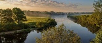
The river valley is a flat plain. The floodplain is poorly expressed. As it approaches the sea, it expands and turns into continuous floodplains, the coastal ramparts stretch along the channel in parallel ridges, rising above the adjacent area by 1.5 - 2 m. Earthen dams were erected on them to protect against floods.
In December - January the Channel is covered with ice, which lasts for 35 - 40 days. Navigation on the river lasts 10 months, and in some years it does not stop at all.
Previously, the river was called “Kara-Kuban” (Black Kuban), “Kumli-Kuban”, “Black Channel” and finally just Channel. The Protoka railway station in the city of Slavyansk-on-Kuban is named after the river.
Settlements on the left bank: the city of Slavyansk-on-Kuban, the village of Serbina, the village. Sovkhozny, village. Pribrezhny, village Sadovy, the villages of Baranikovsky, Neshchadimovsky, Vodny, Pogorelovo, Galitsyn, Krasnoarmeysky town, Zaboysky, Derevyankovka, the villages of Golubaya Niva and Achuevo. On the right: the villages of Tikhovsky, Korzhevsky, Turkovsky, Chigrina, Krizhanovsky, Trudobelikovsky, Protichka, Prototsky, the villages of Cheburgolskaya and Grivenskaya.
Types of fish: Tsutsik goby, Round goby, Verkhovka, Chub, Dace, Silver bream, Asp, Crucian carp, Rudd, Carp, Bream, Tench, Burbot, Perch, Gudgeon, Sturgeon, Roach, Sterlet, Carp, Bluefish, Bleak, Chekhon , Catfish, Pike perch, Pike, Ide.
Reference Information.
Length: 140 km Basin: Sea of Azov River basin: Kuban Source: Kuban River Location: x. Tikhovsky (Krasnoarmeysky district of the Krasnodar Territory) Coordinates: 45°11′06″ N. w. 38°12′47″ E. Ustye village: Sea of Azov Location: Achuevo village (Slavyansky district of the Krasnodar Territory) Coordinates: 45°44′38″ s. w. 37°47′04″ E. d.
span style=”font-size: medium; font-family: 'times new novel', 'times';"
Source
Map of river channel Krasnodar region
Download “ Map of the Kuban River from the Krasnodar hydroelectric complex to the mouth of the river. Channel from source to mouth »
Download “Plavni Kuban - atlas for hunters and fishermen”, 1:100,000
Download “Map of the Kuban River from the Krasnodar hydroelectric complex. » for free, and you can also download many other maps in our map archive
The Kuban River is formed by the confluence of the Uchkulan and Ullu-Kan rivers, flowing from the glaciers of Elbrus and the Watershed Range. The length of the Kuban is 870 km, of which 240 km flows through the Stavropol Territory and 630 km through the Krasnodar Territory of the RSFSR. Flowing initially in a northern and northwestern direction, the Kuban at the village of Temizhbekskaya turns to the west and maintains this general direction until it flows into the Sea of Azov.
The river basin has a sharply asymmetrical shape. On the left, the Kuban receives a number of large tributaries from the northern slopes of the Greater Caucasus, the main of which are the rivers Urup, Laba, Belaya, Pshish, Psekups; there are no significant tributaries on the right. The area of the Kuban River basin is 57,900 km2.
In the upper reaches from the source to the city of Nevinnomyssk, the Kuban is a typical mountain river, rapidly flowing in a narrow valley, with steep, sometimes steep slopes. The average fall of the river in this section is 610 cm/km, the flow speed reaches 22 km/h. At the end of the section, the channel is blocked by a dam, which serves to create a backwater of water and direct it to the Nevinnomyssk irrigation canal.
In the middle section, below the city of Nevinnomyssk, the Kuban gradually becomes a flat river, its valley expands, and a floodplain is formed, the width of which reaches 4 km by the end of the section. The river in the middle section is winding, the bed is sandy and rocky in places; It is divided into branches, forming numerous islands. The average river fall here is 60 cm/km.
From the mouth of the largest tributary, the Laba River, the lower section of the Kuban begins. The river here becomes full of water.
In the lower section, Kuban is regulated. From the village of Voronezhskaya to the Krasnodar hydroelectric complex the Krasnodar reservoir is located. The Krasnodar hydroelectric complex was built in 1974 above the city of Krasnodar. The hydroelectric complex has a head of 13.6 m. In the area of the Fedorovskaya village (153 km), the Fedorovsky hydroelectric complex was built in 1967. Its pressure is 4.64 m. Downstream near the village of Tikhovskaya on the Kuban River, the Tikhov hydroelectric complex is being created with a projected pressure of 2.3 m. Hydroelectric complexes perform several functions: irrigation of land, passage of river vessels, regulation of flow in order to protect against floods and provide conditions for fish farming.
Information and literature about the Protoka River
Contents:
Protoka River - Encyclopedic reference
Protoka is a river in Russia that flows through the territory of the Krasnodar Territory. It is the right branch of the Kuban River. The source is located in the Tikhovsky farm, Krasnoarmeysky district. The channel separates the Slavyansky district from the Krasnoarmeysky and Primorsko-Akhtarsky districts. The length of the river is 140 km. It is navigable along its entire length, but is almost never used in this capacity. Water is actively withdrawn from the river for irrigation of rice systems in the Krasnoarmeysky and Slavyansky districts, as well as for desalination of floodplains. Previously it had other names: Kara-Kuban (Black Kuban), Kumuzyun (“kum” - sand, “uzun” - middle, among), Kumli-Kuban (sandy Kuban), “Black Channel” and simply Channel. The Protoka railway station in the city of Slavyansk-on-Kuban is named after the river. Some settlements located on the left bank: the city of Slavyansk-on-Kuban, village. Sovkhozny, village. Pribrezhny, the villages of Serbina, Baranikovsky, Vodny, Pogorelovo, Krasnoarmeysky town, Zaboysky, the villages of Golubaya Niva and Achuevo. On the right: the villages of Tikhovsky, Krizhanovsky, Chigrina, Trudobelikovsky, Turkovsky, Prototsky, the villages of Grivenskaya and Cheburgolskaya.
ASSESSMENT OF THE ECOLOGICAL STATE OF THE RIVER PROTOKA IN THE CITY OF SLAVYANSK - ON - KUBAN, KRASNODAR REGION
Published in 2021, Issue August 2016, EARTH SCIENCES | No comments yet
Mamas N.N.
Candidate of Biological Sciences, Associate Professor, Kuban State Agrarian University
ASSESSMENT OF THE ECOLOGICAL STATE OF THE RIVER PROTOKA IN THE CITY OF SLAVYANSK - ON - KUBAN, KRASNODAR REGION
annotation
The study of the bank of the Protoka River is caused by the current critical situation, which is characterized by siltation of the river bed and overgrowing of the banks with hygrophytes. Analysis of the total projective cover of vegetation predicts changes in the state of the coast and the development of eutrophication processes. Coastal research is carried out for the purpose of analyzing the ecological state. Having selected plants that are more sensitive to pollution, we used a biotesting method, which allows us to assess the environmental situation. The next step of the work is the use of river silts after cleaning the riverbed in agricultural production.
Key words: Protoka River, general projective cover, biotesting, assessment of ecological condition.
Mamas NN
PhD in Biology, Associate professor, Kuban State Agrarian University
EVALUATION OF THE ECOLOGICAL STATE OF THE RIVER FLOW IN THE TOWN OF SLAVYANSK – NA – KUBANI KRASNODAR TERRITORY
Abstract
The Study of the river Flow caused by the critical situation, which is characterized by siltation of the river bed, clogging the banks of the hygrophytes. The analysis of the total projective cover of vegetation predicts changes in the state Bank and the development of eutrophication processes. The Bank carried out a study with the aim of analyzing the ecological status. Selecting the more sensitive to contamination of the plants, used method of bioassay that allows to assess the environmental situation. The next step is the application of river silt after cleaning of the bed.
Keywords : river Flow, total projective cover, bioassessment, ecological status evaluation.
Aquatic ecosystems play a huge role in the existence of all life on the planet. Without water, it is impossible to imagine most natural and anthropogenic processes. The issue of protecting aquatic ecosystems and rational use of their resources is a matter of life on Earth. Decision-making in this area should be based on reliable information about the state of water bodies and trends in its change.
One of the most important problems of water bodies flowing through cities is pollution from household waste. This mainly occurs as a result of poor performance of public utilities. For the city of Slavyansk-on-Kuban with a population of more than seventy thousand people, this problem is especially acute. This determines the relevance of the study.
The Protoka River, as a steppe river, is characterized by a weak current (velocity no higher than 0.6–0.7 m/s) and shallow depths (1–1.5 m). The river valleys are wide with gentle slopes, on which two terraces are faintly visible. River floodplains include numerous swampy saucer-shaped depressions, gullies and ravines. Natural conditions determine the distribution of plant groups and complexes within the floodplain and their species composition.
The most numerous in terms of species composition in the study area are the families Compositae (31 species, accounting for 23.5% of the total number of plants), cereals (13 species - 9.8%), legumes (11 species - 8.3%), and Lamiaceae (10 species – 7.6%). The average in the number of recorded species were pink (6 species - 4.5%), mallow and sedge (5 species each - 3.8%), umbrella (4 species - 3.0%), buckwheat and goosefoot (3 species each - 2.3%). The remaining families were small and included no more than two species (1.5%).
The coastal part of the river is occupied by yellow thistle, ragwort, and horse sorrel. In general, the vegetation of the valleys of small steppe rivers presents a monotonous picture. In the development of vegetation, its deep degradation is clearly visible, which is expressed in a reduction in phytocenotic diversity. This is due to a radical change in habitats - plowing of virgin lands, siltation of riverbeds, slowdown and complete loss of the “living flow” of water. Vegetation in the river floodplains has not been preserved in its original form. The destruction of the vegetation of river valleys and gullies led to deep disturbances of the entire natural complex (flooding of land, soil erosion, etc.).
The city of Slavyansk-on-Kuban is located within the climatic province of the Azov-Kuban Plain, which is part of the climatic region of the Northern slope of the Greater Caucasus and the plains of the Ciscaucasia. This territory is exposed to polar and Atlantic air masses.
The climate of the region is temperate continental. The main factor determining the peculiarity of the climate is the proximity of the Azov and Black Seas, which significantly soften the continentality, giving the climate a moderately warm character.
In winter, northeast winds predominate, in summer – southwest. Average wind speed is 2.4 m/s. The average number of days with strong winds (more than 15 m/s) is 19, the highest speeds (18-20 m/s).
Meadow-chernozem soils predominate in the study area. They are usually confined to depressions (closed flat depressions), open depressions, deltas and river beds. They are considered semi-hydromorphic analogues of chernozems and have most of the morphological characteristics of zonal soils. They have a different water regime from chernozems, which results in hydromorphic features in the lower soil horizons.
The studied left bank of the Protoka River in Slavyansk-on-Kuban has a stretch of 5 kilometers along the river bed. To conduct research along the river, 3 test sites (SP) measuring 25x25 meters were selected. PP 1 was located in the area of the city stadium and the beach, PP 2 was located in the area of Chernomorskaya Street in the private sector of the city. PP 3 was selected in the area of the Ostrovok forest park in the suburban village of Sovkhozny. All areas are coastal zones with developed tree, shrub and herbaceous vegetation.
The width of the river in the study area varies widely – from 80 to 160 meters. The narrowest place is located near the bridge along Kovtyukha Street, and the widest is 100 meters downstream from the Ostrovok forest park. The average width of the river is 100 meters. The river flow speed is 0.5 m/s and does not change in the central current, however, there are backwaters with almost stagnant water near the banks. The depth of the river is varied: near the banks, in particular at the location of the city beach, the depth does not exceed 2 meters, but in the fairway the depth reaches 5 meters, since the river is navigable.
The description of the species diversity of herbaceous vegetation and the determination of the total projective cover (TPC) were carried out at 3 sampling sites. The main plants predominant on the shore are dandelion (Taráxacum officinále), hogweed (Cýnodon dáctylon), yarrow (Achilléa millefólium), field sow thistle (Sónchus arvénsis), chamomile (Matricāria chamomīlla), great plantain (Plantágo). major).
On the second sample site, a more abundant total projective cover was recorded, which amounted to 70%.
The overall projective coverage is higher on the second survey site. This allows us to conclude that the territory of this site is characterized by compaction. The results of the woody vegetation study show that the trees on the second sample site are in better condition than the trees on the first and third sites. The worst condition of woody vegetation was found at survey site 3, which is probably due to high recreational load. Further in our work we plan to use compost based on river silts when growing crops.
To assess the ecological state of the reservoir and assess the toxicity of river silt, we have chosen the biotesting method - this is a procedure for determining the toxicity of the environment using test objects that signal danger regardless of what substances and in what combination affect the test objects. Due to its simplicity, efficiency and accessibility, biotesting has gained widespread recognition throughout the world.
To conduct the experiment, a 6 kg sample of sludge was taken, then a plant was selected as an indicator of winter wheat grain. Wheat seedlings are most sensitive to pollution. To conduct the experiment, we needed an extract from sludge and clean water, filter paper, plastic cups, and a measuring cup. To obtain an aqueous extract from sludge, take 20 g of sludge and place it in a plastic cup, cover it with a paper filter and fill it with 100 ml of clean tap water and leave until the next day. When starting the experiment, filter paper was placed at the bottom of a plastic cup, then 10 grains of wheat, soaked in a 1% solution of potassium permanganate and washed with water. 10 ml of aqueous extract from sludge was added to each cup, and pure water was added to the control. On day 4, the total germination of grains was calculated and the length of the main root was measured.
As a result of the experiment, we found that plant seedlings are very sensitive to environmental pollution; they are good to use as a test object for biotesting. After placing winter wheat grains in plastic cups, 10 ml of sludge extract was added to the experimental variants for three days, and ordinary water was added to the control.
The experiment showed good germination of wheat in an aqueous extract from sludge. In cups with water extract, wheat sprouts are higher, germination is on average 90%, and the length of the main root is longer in cups with water extract than in the control with plain water. The longest root was 11.2 cm, and the shortest in the control experiment was 0.7 cm.
One can note the positive effect of sludge on wheat germination, which indicates the absence of strong toxic substances in the sludge masses that slow down plant growth.
After the research, we can conclude that the ecological state of the reservoir is satisfactory. The next step of work, after cleaning the riverbed, is the use of river silt in agricultural production.
Literature
- Alekseevsky N.I. Small rivers and the ecological state of the territory / N.I. Alekseevsky, S.O. Grinevsky, P.V. Efremov, M.B. Zaslavskaya, I. L. Grigorieva / Water resources. 2003. T. 30. No. 5. 595 p.
- Andryushchenko V.Yu. Atlas-directory “Natural resources of Kuban” / V.Yu. Andryushchenko, V.G. Goncharov, A.G. Druzhinin, - Rotov-on-Don: Publishing house SKNTs VSh 2004. – 64 p.
- Belyuchenko I.S. Ecological problems of the Kuban steppe zone, causes of their occurrence and solutions / I.S. Belyuchenko // Ekol. Vestnik Sev. Caucasus. – 2011. – T. 7. – No. 3. – P. 47-64.
- Belyuchenko I.S. Assessment of the state of river systems in the steppe zone of the region and proposals for improving their ecological situation / I.S. Belyuchenko, N.N. Mamas // Ekol. problem Kuban. – 2005. – No. 30. – P. 199-207.
- Ryabtseva O.V. Research in the floodplains of rivers in the steppe zone of the Krasnodar Territory / O.V. Ryabtseva, E.V. Solodovnik, N.N. Mamas // Electronic scientific journal of KubSAU, No. 83(09), 2012.
- Mamas N.N. Regulated flow of the flat territory of the Krasnodar Territory / N.N. Mamas, A.A. Prudnikov, Electronic scientific journal of KubSAU. – Krasnodar: KubGAU, 2014. – No. 01 (095).
References
- Alekseevskiy NI Malie reki I ecologishescoe sostoynie territorii / NI Alekseevsky, SO Grinevsky, and PV Efremov, MB Zaslavskaya, LI Grigor'eva / Water. 2003. Vol. 30. N. 5. 595 RUR
- Andryushchenko V. Atlas-reference book “Natural resources Kubani / V. Andryushchenko, VG Goncharov, AG Druzhinin, - Rostov-on-don: Izd-vo sknts VSH 2004. – 64p.
- Belyuchenko IS Ecologicheskie problemi stepnoi zoni Kubani, prichini vosniknovenia I puti solution / IS Belyuchenko // Ecol. Bulletin Of The North. Caucasus. – 2011. – T. 7. – No. 3. – S. 47-64.
- Belyuchenko IS Ocenka coctoyania rechnix system stepnoi zoni krai I predlogenia ulutshenia ecologichescoi situacii/ IS Belyuchenko, NN Mamas // Ecol. Probl. Kuban. – 2005. – N. 30. – S. 199-207.
- Ryabtseva OV Issledovania v poimah rek stepnoi zoni Krasnodarscogo kraya /A. Ryabtseva, EV Solodovnik, NN Mamas // Electronic scientific journal of the Kuban state agrarian University, no. 83(09), 2012.
- Mamas NN Zaregulirovannost stoka ravninnoy territorii Krasnodarscogo kraya / NN Mamas, AA Prudnikov, Electronic scientific journal of the Kuban state agrarian University. – Krasnodar: Kubsau, 2014. – No. 01 (095).
Protoka River
Serves as a water border between two regions, Slavyansky and Krasnoarmeysky, also Primoro-Akhtarsky. The total length of the river is 140 km. It is deep enough along its entire length, so that ships could easily navigate, but the Channel is not used in this way these days. The river's water is used differently; it serves as a natural source of water for irrigating the rice systems of those nearby regions, which it divides as a border.
The channel is also the right branch of another river, the Kuban, starting from the Fedorovsky hydroelectric complex all the way to the edge of the Sea of Azov. Previously, it was called Kara-Kuban or “Black Channel”, then another word disappeared, leaving just Channel.
Character of the river
Downstream it is quite populated. On the left is the Serbina farm, then Slavyansk, to the side are the villages of Sovkhoznoe and Pribrezhnoye, as well as many others. The channel seems to connect them with each other, serving not only as a border in the regions, but also as a connecting link.
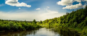
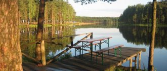
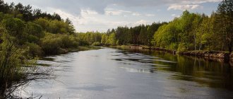
The places there are very beautiful, the shores just beg for a walk. With the arrival of spring, the grass blooms wildly and the trees turn green, painting the world around us with shades of green. In autumn it all turns yellow and red, evoking romantic thoughts. The climate in the region is quite mild, winters are not so severe, frosty days are rare.
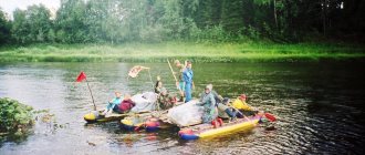
Tourists often come there not only to visit the numerous villages and farmsteads scattered along the banks of the Protoka here and there, but also to simply greet the river, walk along the shore or sit with a fishing rod, fortunately there are plenty of convenient places. The banks are gentle, and here and there there are hills covered with bushes and herbs. The flow of the river is calm, sometimes it seems that it is not moving at all, the water surface is so motionless. In winter, it is covered with ice in places, it lasts for some time, then melts. Spring comes early to those parts, slowly making itself known as early as February. There are many different fish in the Channel, making it attractive to anglers.
Source
Download “Map of the Kuban River from the Krasnodar hydroelectric complex…. » for free, and you can also download many other maps in our map archive
The Kuban River is formed by the confluence of the Uchkulan and Ullu-Kan rivers, flowing from the glaciers of Elbrus and the Watershed Range. The length of the Kuban is 870 km, of which 240 km flows through the Stavropol Territory and 630 km through the Krasnodar Territory of the RSFSR. Flowing initially in a northern and northwestern direction, the Kuban at the village of Temizhbekskaya turns to the west and maintains this general direction until it flows into the Sea of Azov.
The river basin has a sharply asymmetrical shape. On the left, the Kuban receives a number of large tributaries from the northern slopes of the Greater Caucasus, the main of which are the rivers Urup, Laba, Belaya, Pshish, Psekups; there are no significant tributaries on the right. The area of the Kuban River basin is 57,900 km2.
In the upper reaches from the source to the city of Nevinnomyssk, the Kuban is a typical mountain river, rapidly flowing in a narrow valley, with steep, sometimes steep slopes. The average fall of the river in this section is 610 cm/km, the flow speed reaches 22 km/h. At the end of the section, the channel is blocked by a dam, which serves to create a backwater of water and direct it to the Nevinnomyssk irrigation canal.
In the middle section, below the city of Nevinnomyssk, the Kuban gradually becomes a flat river, its valley expands, and a floodplain is formed, the width of which reaches 4 km by the end of the section. The river in the middle section is winding, the bed is sandy and rocky in places; It is divided into branches, forming numerous islands. The average river fall here is 60 cm/km.
From the mouth of the largest tributary, the Laba River, the lower section of the Kuban begins. The river here becomes full of water.
In the lower section, Kuban is regulated. From the village of Voronezhskaya to the Krasnodar hydroelectric complex the Krasnodar reservoir is located. The Krasnodar hydroelectric complex was built in 1974 above the city of Krasnodar. The hydroelectric complex has a head of 13.6 m. In the area of the Fedorovskaya village (153 km), the Fedorovsky hydroelectric complex was built in 1967. Its pressure is 4.64 m. Downstream near the village of Tikhovskaya on the Kuban River, the Tikhov hydroelectric complex is being created with a projected pressure of 2.3 m. Hydroelectric complexes perform several functions: irrigation of land, passage of river vessels, regulation of flow in order to protect against floods and provide conditions for fish farming.
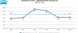
The average annual flow of the Kuban at the Krasnodar water gauging station is 13.5 km3. The maximum water flow discharged into the downstream of the Krasnodar hydroelectric complex is about 1300 m3/s.
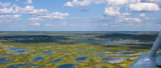
At a distance of 117.5 km from the mouth, a navigable branch is separated to the right of the Kuban River - the Protoka River, 133 km long. The channel flows into the Sea of Azov below the village of Achuevo. From the source of the Protoka River begins the vast Kuban delta with the most fertile soils; The delta area is 4500 km2.
The bed of the Kuban River, especially in the middle part, is subject to deformation. The destruction and sliding of the banks is largely caused by waves of unsteady flow during releases from. reservoirs. Coasts composed of sand, sandy loam and loam are most susceptible to erosion.
The national economic importance of the Kuban and Protoka rivers has increased significantly with the commissioning of the Krasnodar hydroelectric complex. The waters of these rivers began to be more fully used for irrigation of agricultural land, in particular rice fields. The construction of the dam significantly reduced the threat of large floods that caused damage to the region's agriculture. Conditions have improved for the further development of fisheries. The importance of the Kuban and Protoka rivers as transport routes has also increased, especially for passenger transportation and the transportation of mineral and construction cargo.
The climate of the Kuban River basin is soft, formed under the influence of warm and humid masses of Black Sea air. The duration of the warm period, from a stable transition of the average daily air temperature through 0°C in the spring to the transition to negative temperatures in the fall, is on average 250 days. According to long-term observations, the average date for the air temperature to cross 0°C in the spring is March 17, in the fall - November 23. The annual range of extreme air temperatures is 55–60°C.
Winter here is warm, unstable, with thaws, and begins in mid-December. The average air temperature in January is minus 1.5°C. The absolute minimum temperature is minus 20°C. Spring usually begins in late February - early March, when the average daily temperature rises above 0°C. Due to the rapid change of air masses, spring is characterized by the return of cold weather.
Summer in the Kuban basin is clear and warm. The warmest month is July. The average air temperature in July is plus 23-24°C. The absolute maximum temperature is plus 39°C.
In the second half of October frosts begin. The average daily air temperature during this period does not rise above plus 10°C. Autumn is characterized by increased cloudiness and fog.
Winds. The wind regime in the Kuban River basin is characterized by the predominance of winds in eastern and western directions throughout the year, and eastern winds are more often observed in the period from September to March. In summer, winds mainly blow from the southwest.
The average annual wind speed varies across the territory from 2.5 to 5.5 m/s. During the navigation period, the wind speed averages 2.8–4.9 m/s.
The number of days with strong winds, the speed of which exceeds 15 m/s, is 8-11 per year. The highest wind speeds are observed in the winter-spring period with an average monthly maximum in February - March. The maximum observed wind speed in the Kuban basin is 33–35 m/s. Strong and even moderate winds are accompanied by dust storms.
Fogs and precipitation. The average number of days with fog on the Kuban and Protoka rivers is 35 per year. Fogs are observed mainly in the cold season (October - March) - up to 6 days a month. Their duration during this period averages 6-7 hours per day. In the warm season (April - September) there are no more than two days with fog per month. Fogs, as a rule, appear at night and in the morning and last for about 3-3.5 hours.
The average annual precipitation in the mapped area varies from 550 mm in the west to 750 mm in the east. During the navigation period, up to 400 mm of precipitation falls, the maximum of which (60-80 mm per month) occurs in June - July.
Showers and hail are common during the summer months. Thunderstorms occur between May and October.
Areas difficult for navigation . On the Kuban River from the Krasnodar hydroelectric complex to the mouth and on the Protoka River from source to mouth there are many sharp bends that make it difficult to see the shipping passage, as a result of which the detection of vessels in oncoming traffic occurs at a short distance, which requires special caution from navigators. In some areas, swimming is complicated by pressure currents acting in narrow areas, steep bends and bends. At night, in the area of large populated areas, due to the large accumulation of extraneous light sources on the shore, the signal lights of ships and the lights of navigational signs are difficult to distinguish.
When the upper tail of the Fedorovsky hydroelectric complex is open, the depths on the approach to the lock are reduced to the guaranteed ones. As a result of large drift conditions, navigation conditions in the upper approach channel become more difficult.
A detailed description of difficult sections for navigation and sections of the route where passing and overtaking are prohibited are given on the corresponding sheets of the map.
When sailing on the Kuban and Protoka rivers, all vessels must maintain a constant VHF radio watch in order to safely pass oncoming vessels.
PORTS AND MARINES. On the mapped section of the Kuban River there are two ports of the Kuban River Shipping Company: Krasnodar and Temryuk; The port berths are equipped with mechanization equipment for loading and unloading operations. In addition, in Kuban there are piers Krasnodar, Afips, Fedorovskaya, Ivanovskaya, Varenikovskaya and Temryuk.
On the Protoka River there are Slavyanskaya and Grivenskaya piers.
On the Kuban and Protoka rivers there are also berths and unloading points for ships transporting mineral and construction cargo.
Telephone, intercom and VHF radio stations are available in ports and marinas.
The procedure for mooring ships at berths is determined by the “Fire Safety Rules on Ships and Coastal Facilities of the Ministry of River Fleet of the RSFSR.”
Fleet Maintenance . Ships are supplied with fuel and lubricants in the Krasnodar backwater, at the Ivanovskaya pier and in the Temryuk port. You can replenish your supply of drinking water in the backwaters of Pashkovsky, Gorsky, Krasnodarsky, Slavyansky, at the Ivanovskaya pier and in the Temryuk port. Current repairs of ships are carried out in the Krasnodar and Temryuk ports, at the Slavyanskaya pier and in the Krasnodar backwater.
Historical reference
In written sources until the end of the 19th century it is mentioned under the name Rotok
, which gave the name to the entire historical area of Belaya.
The ancient Russians called this river by the name Rut
. It was in the tract near Ruta that a large detachment of Tatars was defeated by united Russian-Lithuanian forces in 1511. For a long time, this event was considered the first victory over the Tatars, due to the fact that in the book of legends about the localities of the Kyiv province a typo was made and instead of “1511”, “1311” was printed [3]. This caused a number of misunderstandings - this date was indicated even in dissertations and textbooks on local history of Porosye.
Notes
- ↑Hydroecological assessment of the Ros River
- ↑A. P. Stadnichenko, R. K. Melnichenko, L. M. Yanovich, G.E. Kirichuk, O. P. Zhitova. “The role of mollusks in the distribution of radionuclides in aquatic ecosystems”
- ↑ L. I. Pokhilevich. "The Legend of the populated areas of the Kyiv province." page 490
What is wiki2.info Wiki is the main information resource on the Internet. It is open to any user. Wiki is a library that is public and multilingual.
The basis of this page is on Wikipedia. The text is licensed under CC BY-SA 3.0 Unported License.
Wikipedia® is a registered trademark of the Wikimedia Foundation, Inc. wiki2.info is an independent company and is not affiliated with the Wikimedia Foundation.
- Categories
- Featured Lists
- Portals
- Current events
- Articles of the year
Source