Hydrology
- Water system: Chusovaya → Kama → Volga → Caspian Sea.
- The nature of the flow: in the upper reaches - foothills, in the middle and lower reaches - flat.
- Reservoirs: Permyakovsky pond, Sylvinsky reservoir, Sylvinsky pond.
- Bottom: mostly rocky and pebbly, there are also sandy and clayey places.
Fishing on Sylva – fishing with passion
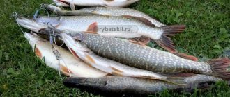
Fishing on Sylva is carried out all year round. In the river you can catch such fish as perch, ruffe, gudgeon, pike perch, burbot, bleak, roach, dace, ide, bream, carp, pike, sabrefish and tench. Fish can be caught in the upper sections of the river, on the rifts and at the mouth. Local fishermen prefer bends under steep banks, where holes washed away by the current are convenient for fishing.
Chub caught on Sylva
The most popular places for fishing on the Sylva River in the Perm Territory: the village of Lyady, Sylva, Troitsa, Lyady, Mostovaya, Novosely, Snegiri, the city of Kungur, Posad, Sukhoi Log, Mazuevka, Sasykovo, Torgovishche. You can fish with regular and bottom fishing rods, as well as spinning rods. Fishing is usually done from the shore; in the lower reaches, fishing from a boat is popular.
Sources:
https://reki-ozera.ru/otcheti_o_rybalke/108842-sylva.html?msg=22 https://urochishe.ru/vodnyie-obektyi/syilva-reka/ https://reki-ozera.ru/otcheti_o_rybalke/108842 -sylva.html?msg=22 https://parmaday.ru/river/reka-sylva
Tributaries
Main article: "Tributaries of the Sylva".
| Rights | Left | |
| SOURCE | ||
| Aleshin Log | 489 | |
| 484 | Bolshoi Kosogorny | |
| Vaska | 482 | |
| Sukhoi Vaska | 480 | |
| Kultysh | 478 | |
| Trash | 475 | |
| 470 | Sarga | |
| Steep | 465 | |
| 463 | Shawl | |
| Bolshaya Lomovka | 457 | |
| Lomovka | 455 | Varlashevka |
| Sosnovka | 450 | |
| Kopanets | 445 | |
| Mazanka | 437 | |
| Wild duck | 433 | |
| Lugovaya | 421 | |
| Izhbolda | 416 | |
| Big Bee | 387 | |
| Black | 383 | |
| 380 | Sharpening | |
| 379 | Eltsovka | |
| Kedrovka | 378 | |
| Chelpashek | 373 | |
| Talezhanka | 364 | |
| Urma | 362 | |
| Kamenka | ||
| Malaya Urma | 355 | |
| Borodinka | 354 | |
| Kureynaya | 350 | |
| Biz | 337 | |
| Duvanka | 328 | |
| 324 | Platonovka | |
| Big Hook | 314 | |
| 311 | Dmitrievka | |
| 309 | Dirty | |
| 304 | Shamarka | |
| Salty | 300 | |
| 295 | Big Kozyal | |
| old woman | 292 | |
| 290 | Vogulka | |
| Baskaya | 284 | |
| Vyazovochka | 276 | |
| 270 | Settlement | |
| 267 | Kuryl | |
| Black | ||
| Lipok | 263 | |
| Kamenka | 260 | |
| 254 | Kurya | |
| Molebka | 250 | |
| Ishimovka | 241 | |
| Bolshaya Kamenka | 234 | |
| 226 | Vyazovka | |
| 222 | White Mountain | |
| Bogodonovka | 220 | |
| Baybalda | 218 | |
| Red Meadow | 216 | |
| 208 | Studenyi Log | |
| 206 | Berezovka | |
| Syzganka | 191 | |
| 187 | Ut | |
| 184 | Berdykaevsky | |
| 182 | Checkarda | |
| Big River | 178 | |
| 174 | Baybalda | |
| 167 | Tisa | |
| 155 | Irgina | |
| Yurkan | 147 | |
| 140 | Shatlyk | |
| 134 | Sandushka | |
| Istekaeva | 128 | |
| Yusupovka | 120 | |
| Mechinka | 118 | |
| 108 | Mazuevka | |
| 94 | Karabarakin | |
| 91 | Chubykchovsky | |
| Lek | 89 | |
| Barda | 83 | |
| Pelvis | 73 | |
| 61 | Kishert | |
| Shakwa | 26 | Iren |
| 21 | Grandma | |
| Mechka | 122* | |
| 105* | Malaya Yakshovka | |
| 88* | Vaskin | |
| 87* | Levshina | |
| 85* | wild | |
| Serga | 78* | |
| 60* | Cheese | |
| Nozzle | 51* | |
| 30* | Bykovka | |
| 28* | Bolshaya Voronovka | |
| 27* | Pavement | |
| Yurman | 23* | |
| Kutamysh | 22* | |
| Denisovka | 18* | |
| Half | 15* | |
| Bykovka | 11* | |
| 2* | Lyadovka | |
| MOUTH | ||
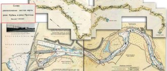
Scheme 1. Tributaries of the Sylva. The numbers indicate the distance (in kilometers) from the place where the Kama Reservoir begins (Sylva Bay), the numbers with asterisks indicate the geographical mouth of the Sylva.
Rafting on Sylva
The river is popular among lovers of water tourism, especially in the section from Kisherti to Kungur (although it, of course, cannot compete in popularity with Chusovaya or Usva). Suitable for rafting throughout the entire season - from early May to September. Some tributaries of the Sylva are also suitable for rafting - the rivers Vogulka, Babka, Iren, Barda.
The length of the section of the Sylva River suitable for rafting is more than 300 kilometers.
The river bed winds strongly, the intricate loops are clearly visible on the map. Lots of rolls. In the summer, there are often places on the reaches that are abundantly overgrown with algae, which greatly complicate rowing.
There are many settlements here. In villages and hamlets encountered along the way, you can replenish food supplies. Many villages remained only on old maps and no longer exist these days. You can talk about Sylven villages for a long time, but here I will write only about the most interesting.
In the lower part of the Sylva River (behind Kishertya), karst is highly developed; grottoes and caves are found in the coastal rocks. The most famous cave in the valley of the Sylva River is Kungurskaya. It is definitely worth a visit if you finish rafting in the city of Kungur.
Geography
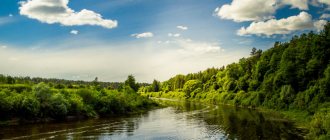
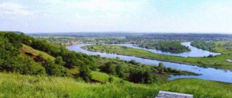
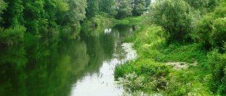
- Coastal landscape: the river flows through hilly terrain, among coniferous, mixed and deciduous forests. In some places it winds strongly, forming oxbow lakes. From time to time you come across sandstone and limestone rocky outcrops along the shores. Karst is developed in the lower reaches of the river.
- Settlements on the banks: Permyaki, Sylva, Shigaevo, Koptely, Teplyaki, Kedrovka, Simonyata, Roshcha, Niz, Platonovo, Koptelo-Shamary, Shamary, Nizhnyaya Baska, Kremlevo, Molebka, Krasny Lug, Berezovka, Agafonkovo, Tis, Ust-Irgino , Suksun, Ust-Kishert, Kungur
Source
- Coordinates: 57°14′15″ N. latitude, 59°03′05″ e. d.
- Altitude above sea level: 380 m.
- Topographical landmark: a spring in the vicinity of the village of Vyrubki.
Estuary
- Coordinates: 58°06′50″ N. latitude, 56°37′50″ e. d.
- Altitude above sea level: 108.2 m.
- Location: Chusovaya River - left bank 21 km from its mouth - within the boundaries of the village of Lyady.
Territorial location
- COUNTRY: RF . Region: Perm region . Districts: Kishertsky, Kungursky, Permsky, Suksunsky.
- District: Shalinsky.
Interactive map
Fishing on Sylva, Perm region
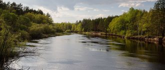
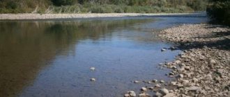
Sylvensky Bay of the Kama Reservoir.
near the village Trinity
Photo Photo by Nikolay Sintsov
The river rarely bites asp, ide, podust and pike perch. But you can count on good catches of chub, and within the backwater of the ponds - white bream and chebak. Pike bite throughout the current, but its size is not record-breaking. In the Sylva and its tributaries, grayling, saberfish, asp, bream, minnow, perch, gudgeon, burbot, ruffe, as well as rainbow trout, which were previously bred in the pond of the village of Molmys, are biting, and are now bred in many ponds of the Sylva River.
It makes sense for fly fishing enthusiasts to climb into the upper reaches to fish for small grayling. Avid spinning anglers will be interested in fishing for pike perch in the middle and lower reaches of the Sylva, for example, the rift below the village of Kashirino and the Sylva Bay. In addition to pike perch, bream, sterlet, saberfish and asp are also caught in the bay. After the confluence of the Lipok River, long beautiful reaches up to 70 cm deep begin. Dace bites well in them.
The best fishing is in the furrows. These are places where the river makes a turn and a ditch is washed out under a steep rocky bank. There are mostly logs left over from the rafting of the leva, and in such places the fish stay. There are places where large boulders have rolled down from the mountain into the river. There are usually piles of logs accumulated there too. Quiet and deep reaches can also be considered promising places.
Direction from Yekaterinburg: Serov Distance to the nearest access point (range): over 300 km How to get there:
You can go to the upper reaches by the road Ekaterinburg - Pervouralsk - Shalya village - Shamary - Sylva River. In the lower reaches you need to look for exits from the Ekaterinburg - Perm road.
You can get to the river above the city of Kungur by train; the railway line runs almost along the river valley, stopping at the very shore. Some places can also be reached by car.
Depths average upper/lower reaches: 5/10m Catchment area: 19,700 km 2 Tributaries: Main left: Irgina, Vogulka, Babka, Iren, Kishertka; the right ones are Shakva, Barda, Molebka and Lek. Origins: southwest of the Sverdlovsk region, outskirts of the station. Cuttings of the Kuzino-Chusovskaya railway. Coordinates: 57°15′00″ N. w. 59°02′42″ E. d. Width in the upper/middle/lower reaches (m): 10/75/300 Average current speed (except for rapids): 2.5-3 km/h Fee: Free Bottom: the river bottom is strewn with driftwood. A comment:
Dear fishermen! If you see an error in the description or you have photographs of this reservoir and are ready to share them, send your Rivers-Lakes to our mail.
Mouth: Chusovsky Bay of the Kama Reservoir, 21 km from the mouth. Coordinates: 58°06′28″ N. w. 56°38′16″ E. Elevation difference from mouth to source: 124-232 Settlements on the shore: Permyaki village, Sylva village, Koptely, Kedrovka, Roshcha, Niz, Platonovo village, Koptelo-Shamary village, Shamary village, Nizhnyaya Baskaya village, Molebka, Krasny Lug , Berezovka, Agafonkovo, Tis, Ust-Irgino, Suksun, Kungur, Morozkovo. Possibility of rafting: yes Minimum length of the route for rafting: 4 Maximum length of the route for rafting: 32 Routes for rafting and parking:
1. The route can start from the tourist complex “Stalagmite”, located on the right bank of the Sylva River in the area of the Kungur Ice Cave. 2.st. Shalya - s. Sylva - village Koptely -s. Grove. 103 km. (By the Perm-Sverdlovsk passenger train or electric trains with a transfer in Kungur, you will get to the Shalya station. Near the station there is a village of the same name - the regional center of the Sverdlovsk region. A regular bus leaves from the station every hour to the village of Sylva. To start sailing along the Sylva, you need to walk along the road to the dam lower pond to the village of Nizhnyaya Sylva.) 3.s. Grove - village Platonovka - village Shamara. 60 km. From the village of Roshcha Sylva turns south. The left bank is high, the right bank is low, you can see an old raft on it; timber used to be rafted from here. Until now, the bottom of Sylva from Urma to Shamar is covered with logs. 4.pos. Shamary - village Yew. 130 km.
Lakes and reservoirs along the way:
Peculiarities:
The Sylva River is a former left tributary of the Chusovaya River, after the construction of the Kama Hydroelectric Power Station dam, the Sylva ceased to be considered its tributary, now the mouth of the Sylva is the Chusovsky Bay of the Kama Reservoir. The Sylva flows mainly to the west, flowing through the Sverdlovsk region (about a third of its length) and through the Perm region. The river is full of water, the water is clean, the bed is very winding, with many riffles and shoals. The diet is mixed, with a predominance of snow. The average water flow 45 km from the mouth is 139 cubic meters/sec. It freezes at the end of October - beginning of November, is characterized by frosts, and opens in the second half of April. During high water, the river flow speed increases to 4-5 km per hour. Forests and meadows grow along the banks.
The Sylva River is very picturesque and has great tourism potential. Like all the rivers of the Middle and Northern Urals, the Sylva is simply studded, like a string of pearls, with coastal rocks, and there are also caves. But there is also a difference from other rivers. The stones on the banks are not located singly, but have the character of peculiar walls. Sylva is interesting for lovers of water travel; during the route you will be able to see the Ermak rock and make a foray into the Moleb anomalous zone. It is very winding and changes direction three times along its length. There are many riffles, shoals and holes. All this together makes it very interesting for water tourism and sport fishing. Just behind the dam is the village of Niz. Behind it, Sylva makes three bends, then runs into steep wooded mountains and turns back. It is difficult to land on the shore, rocky outcrops drop into the water, and many springs flow from the steep banks into Sylva. Then the river emerges from its steep banks and the valley widens. Soon you will see the village of Olkhovka on the right. The Lomovka River flows near it. A little lower, in front of the uninhabited village of Shaidurova, on the left bank rises the Black Prisada rock. There are steep screes, with rocky rifts below them. Beyond Palenki, Sylva turns smoothly. On the left bank is the village of Kurul. Beyond it the river makes a sharp turn to the north. At the very turn there is a deep pool. Soon the high banks, consisting of strong rocks, force Sylva to deviate to the southwest. On the right, the Lipok River flows in, from which long beautiful reaches up to 70 cm deep begin. Dace bites well in them.
Attractions
Molebskaya “anomalous zone”
A certain territory between the villages of Molebka and Kamenka, mostly concentrated on the left bank of the Sylva River. At the end of perestroika - just at the time when the boom in aliens and other “paranormal” things began in the media - it was advertised by some individuals as a place where inexplicable phenomena allegedly occur and UFOs appear (although in fact some of the unusual observations had a rational explanation, and some were completely fiction). The “Anomalous Zone” quickly became popular among lovers of all things mysterious. At present, local authorities are making attempts to use this place as a tourism site.
Kungur Ice Cave
Located on the right bank of the Sylva - in the vicinity of the village of Filipovka (on the outskirts of the city of Kungur). It is one of the largest karst caves in the European part of Russia. Its length is about 5.7 km, of which 1.5 km is equipped for visits by tourists. The center of the cave is always humid (100%) and the temperature varies from -2°C to +5°C. Thanks to this, bizarre ice stalactites and stalagmites freeze in it during the winter. The cave contains 58 grottoes, 146 “organ pipes” - high shafts reaching almost to the surface (the longest is located in the Ethereal Grotto, its height is 22 m). Also under the cave arches there are 70 lakes, in one of them a unique crustacean, Gammarus, was discovered, which is found only here and nowhere else. The age of the Kungur cave is more than 10-12 thousand years.
Fishing on Sylva, Perm region
Sylvensky Bay of the Kama Reservoir.
near the village Trinity
Photo Photo by Nikolay Sintsov
The river rarely bites asp, ide, podust and pike perch. But you can count on good catches of chub, and within the backwater of the ponds - white bream and chebak. Pike bite throughout the current, but its size is not record-breaking. In the Sylva and its tributaries, grayling, saberfish, asp, bream, minnow, perch, gudgeon, burbot, ruffe, as well as rainbow trout, which were previously bred in the pond of the village of Molmys, are biting, and are now bred in many ponds of the Sylva River.
It makes sense for fly fishing enthusiasts to climb into the upper reaches to fish for small grayling. Avid spinning anglers will be interested in fishing for pike perch in the middle and lower reaches of the Sylva, for example, the rift below the village of Kashirino and the Sylva Bay. In addition to pike perch, bream, sterlet, saberfish and asp are also caught in the bay. After the confluence of the Lipok River, long beautiful reaches up to 70 cm deep begin. Dace bites well in them.
The best fishing is in the furrows. These are places where the river makes a turn and a ditch is washed out under a steep rocky bank. There are mostly logs left over from the rafting of the leva, and in such places the fish stay. There are places where large boulders have rolled down from the mountain into the river. There are usually piles of logs accumulated there too. Quiet and deep reaches can also be considered promising places.
Direction from Yekaterinburg: Serov Distance to the nearest access point (range): over 300 km How to get there:
You can go to the upper reaches by the road Ekaterinburg - Pervouralsk - Shalya village - Shamary - Sylva River. In the lower reaches you need to look for exits from the Ekaterinburg - Perm road.
You can get to the river above the city of Kungur by train; the railway line runs almost along the river valley, stopping at the very shore. Some places can also be reached by car.
Depths average upper/lower reaches: 5/10m Catchment area: 19,700 km 2 Tributaries: Main left: Irgina, Vogulka, Babka, Iren, Kishertka; the right ones are Shakva, Barda, Molebka and Lek. Origins: southwest of the Sverdlovsk region, outskirts of the station. Cuttings of the Kuzino-Chusovskaya railway. Coordinates: 57°15′00″ N. w. 59°02′42″ E. d. Width in the upper/middle/lower reaches (m): 10/75/300 Average current speed (except for rapids): 2.5-3 km/h Fee: Free Bottom: the river bottom is strewn with driftwood. A comment:
Dear fishermen! If you see an error in the description or you have photographs of this reservoir and are ready to share them, send your Rivers-Lakes to our mail.
Mouth: Chusovsky Bay of the Kama Reservoir, 21 km from the mouth. Coordinates: 58°06′28″ N. w. 56°38′16″ E. Elevation difference from mouth to source: 124-232 Settlements on the shore: Permyaki village, Sylva village, Koptely, Kedrovka, Roshcha, Niz, Platonovo village, Koptelo-Shamary village, Shamary village, Nizhnyaya Baskaya village, Molebka, Krasny Lug , Berezovka, Agafonkovo, Tis, Ust-Irgino, Suksun, Kungur, Morozkovo. Possibility of rafting: yes Minimum length of the route for rafting: 4 Maximum length of the route for rafting: 32 Routes for rafting and parking:
1. The route can start from the tourist complex “Stalagmite”, located on the right bank of the Sylva River in the area of the Kungur Ice Cave. 2.st. Shalya - s. Sylva - village Koptely -s. Grove. 103 km. (By the Perm-Sverdlovsk passenger train or electric trains with a transfer in Kungur, you will get to the Shalya station. Near the station there is a village of the same name - the regional center of the Sverdlovsk region. A regular bus leaves from the station every hour to the village of Sylva. To start sailing along the Sylva, you need to walk along the road to the dam lower pond to the village of Nizhnyaya Sylva.) 3.s. Grove - village Platonovka - village Shamara. 60 km. From the village of Roshcha Sylva turns south. The left bank is high, the right bank is low, you can see an old raft on it; timber used to be rafted from here. Until now, the bottom of Sylva from Urma to Shamar is covered with logs. 4.pos. Shamary - village Yew. 130 km.
Lakes and reservoirs along the way:
Peculiarities:
The Sylva River is a former left tributary of the Chusovaya River, after the construction of the Kama Hydroelectric Power Station dam, the Sylva ceased to be considered its tributary, now the mouth of the Sylva is the Chusovsky Bay of the Kama Reservoir. The Sylva flows mainly to the west, flowing through the Sverdlovsk region (about a third of its length) and through the Perm region. The river is full of water, the water is clean, the bed is very winding, with many riffles and shoals. The diet is mixed, with a predominance of snow. The average water flow 45 km from the mouth is 139 cubic meters/sec. It freezes at the end of October - beginning of November, is characterized by frosts, and opens in the second half of April. During high water, the river flow speed increases to 4-5 km per hour. Forests and meadows grow along the banks.
The Sylva River is very picturesque and has great tourism potential. Like all the rivers of the Middle and Northern Urals, the Sylva is simply studded, like a string of pearls, with coastal rocks, and there are also caves. But there is also a difference from other rivers. The stones on the banks are not located singly, but have the character of peculiar walls. Sylva is interesting for lovers of water travel; during the route you will be able to see the Ermak rock and make a foray into the Moleb anomalous zone. It is very winding and changes direction three times along its length. There are many riffles, shoals and holes. All this together makes it very interesting for water tourism and sport fishing. Just behind the dam is the village of Niz. Behind it, Sylva makes three bends, then runs into steep wooded mountains and turns back. It is difficult to land on the shore, rocky outcrops drop into the water, and many springs flow from the steep banks into Sylva. Then the river emerges from its steep banks and the valley widens. Soon you will see the village of Olkhovka on the right. The Lomovka River flows near it. A little lower, in front of the uninhabited village of Shaidurova, on the left bank rises the Black Prisada rock. There are steep screes, with rocky rifts below them. Beyond Palenki, Sylva turns smoothly. On the left bank is the village of Kurul. Beyond it the river makes a sharp turn to the north. At the very turn there is a deep pool. Soon the high banks, consisting of strong rocks, force Sylva to deviate to the southwest. On the right, the Lipok River flows in, from which long beautiful reaches up to 70 cm deep begin. Dace bites well in them.
Fishing on the Sylva River
- Types of fish: perch
- ruff
- zander
- Demoiselle minnow
- gudgeon
- Russian bystryanka
- bleak
- roach
- dace
- chub
- ide
- asp
- Podust Volzhsky
- bream
- saberfish
- carp
- tench
- pike
- grayling
- rainbow trout
- burbot
- sterlet
Fishing spots
Conventionally, the river can be divided into 6 sections:
- The origins are from the spring that gives rise to the Sylva River to the pond in the village of Permyaki. The riverbed in this area is a small stream; fish here include minnows and small grayling.
- The very upper reaches are from the Permyakovsky pond to the Sylvinsky reservoir. Closer to the place where it flows into the reservoir, fish such as gudgeon, bleak, roach, small perch, ruff, and pike appear.
- The upper section is from the lower Sylvinsky pond to the mouth of Bolshaya Bizi. Here the river meanders strongly, and in summer it is densely overgrown with aquatic vegetation in places. The ichthyofauna is replenished with dace, chub, roaches, and asp and bream are also periodically caught in the lower part of this area.
- The middle section is from the mouth of the Bolshaya Bizi to the mouth of the Irgina. Starting from here, the river is strewn with logs left over from the rafting of timber that was carried out along Sylva in the past. Lots of rolls. Places interesting for grayling fishing. In the cold season, burbot is caught here. Among the fish listed in the Red Book, the Russian Bystryanka is noted.
- The lower section is from the mouth of the Irgina to the confluence with the Kama Reservoir. Depths of 2-3 meters are not uncommon here, but in some places there are also deeper holes - up to 5 meters. Among the new fish, pike perch begins to be found (closer to the bay). There are a lot of chub, there are large asp with pike and quite decent perch. Here they catch bream and other fish on donkeys.
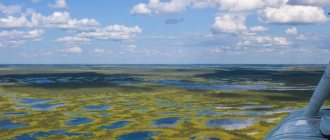
- Sylva Bay of the Kama Reservoir - the backwater of the reservoir begins to manifest itself 127 km from the geographical mouth of Sylva - approximately in the place where the village of Snegiri is located in the Kungur region. This is also where the reservoir formally begins. However, for some distance from here the river continues to have a slight slope. Only near the village of Serga does the channel widen significantly and the water line stops decreasing - this is where the bay begins. The average depth in it is about 10 meters, the maximum exceeds 20. Here, fishermen’s catches most often include perch, pike perch, roach, bream, and ide. From time to time, saberfish and carp are caught. Sterlet was noted (very rare, in the Red Book of the region).
Fishing Features
Among local residents, fishing is popular at the bends - under the steep bank, where the current washes out the holes. In addition, the fish also stands in the rubble of logs and behind underwater obstacles such as stones. In the upper reaches of the river (approximately up to Shamar), poaching flourishes, and therefore one cannot count on good fishing there.
Rivers of the Perm region
About 30 thousand large and small rivers flow through the territory of the Perm Territory. While some rivers calmly carry their deep waters, others rush furiously along rapids and rifts, between rocky shores. Since the rivers have such a different character, the fish that live in them have a diverse species composition. Before deciding on the choice of reservoir, the angler must decide what kind of fish he wants to catch.
Fishing on the Kama
The Kama River is one of the largest waterways in the region. It is home to more than 30 species of fish. Amateur fishing is very common on the Kama. The most common predatory fish are:
- chub,
- pike,
- perch,
- zander,
- asp,
- som,
- burbot.
In the very upper reaches of the Kama and the rivers flowing into it, grayling and taimen may be present in the catches. If grayling can be eaten, then taimen is listed in the Red Book and should be released immediately. Grayling in the upper reaches of the Kama can be caught with a spinning rod using small spinners and wobblers, but the most interesting way to catch this fish is fly fishing. Artificial flies that imitate caddisflies and mayflies can be used as fly fishing baits. Taimen takes better on large oscillating spoons and large wobblers of natural colors.
The remaining species of predators live slightly downstream of the river, where there are more significant depths. The chub sticks to less wide areas on the river. It can be found near the coastal zone, under bushes hanging over the water, as well as on numerous rifts in the middle reaches of the river. Chub, like grayling, are excellently caught with fly fishing gear. For catching chub, flies that imitate various caterpillars that live in abundance on coastal bushes, or imitations of large beetles are better suited.
On the Kama, it is not uncommon to catch trophy specimens of predators. Pike, pike perch and perch follow a calmer current and hunt at depths of 2 to 8 meters. These predators are excellently caught throughout the season on:
- spinners,
- wobblers,
- silicone baits.
Catfish prefer to stay close to underwater holes and are often caught when fishing for pike perch using jig baits. The asp bites well throughout the entire period of open water. To catch it, you should use compact oscillating spinners of the “castmaster” type.
Burbot on the Kama is best caught in February, after spawning. It is usually caught using baitfish, using dead fish as bait. In the upper reaches of the Kama there are a large number of oxbow lakes, where crucian carp and tench live. These types of fish prefer to peck at the worm. In areas with moderate currents, other peaceful fish are found:
- dace,
- gudgeon,
- bystryanka,
- bream,
- white-eye,
- minnow.
All these fish are perfectly caught with traditional float tackle, using plant and animal baits. If you are going to fish for several days, you should stock up on worms in advance: it is not always possible to find them on the shore.
Local fishermen, for a small fee, will take you to the most fishing spots on the river and tell you about the behavior of the local fish.
Vishera River
This river is especially popular among grayling fishermen. Vishera is home to a huge population of this fish species. Record specimens can reach a mass of more than 2 kilograms. Grayling is mainly found in the upper reaches of the Vishera, near rapids and rifts. Since practically no one lives in the upper reaches of the river, you can only get there by water or by helicopter. It is necessary to pay attention to the fact that in this section of the river there is a nature reserve in which fishing is prohibited. In addition to grayling, in the upper reaches of the Vishera there are:
- minnow,
- taimen,
- loach,
- nelma
There are many villages along the banks of the middle reaches of the river. In good weather you can get here by car. In this area of the reservoir you can also catch grayling very successfully. True, its size is more modest than in the upper reaches. In addition to grayling, you can catch here:
- ide,
- perch,
- podusta,
- roach,
- dace,
- pike.
If you have enough time, you can organize a multi-day rafting trip on the river, on a kayak or catamaran. You will have the opportunity to fish on numerous tributaries of the Vishera, fishing on which is no less exciting than on a large river.
In the lower reaches, the Vishera is highly susceptible to anthropogenic impact, so fish stocks in the lower reaches of the river are less rich.
Fishing on Sylva
This river is famous for the presence of large chub, which are caught quite consistently throughout the year. In open water, it can be successfully caught with spinning and fly fishing, as well as with a float rod, worm and bark beetle larva. In winter, the chub bites on a jig with a worm, bloodworm or maggot attached.
In the lower reaches of the river you can catch good fish for medium-sized bream and chebak. In Sylvensky Bay there are quite a lot of pike perch, which often turn out to be a trophy for spinning anglers. Small pike bite well throughout the river , but, unfortunately, their size rarely exceeds 3 kilograms. The most promising places for catching dace are located after the Lipka River flows into the Sylva. In this place, the Sylva spills into very picturesque shallow reaches with a depth of about a meter.
The upper reaches of the Sylva are rich in grayling, so these places are especially interesting for fly fishermen. Although the size of the local grayling is not trophy, the number of bites can please any fan of fishing with an artificial fly. In the tributaries of the Sylva there is the possibility of catching rainbow trout, which can also be caught with fly fishing gear using various imitations of flying insects.
Since most large rivers were used for rafting timber, the best places to catch large fish are considered to be sharp bends in the river. In such places, many sunken trees have accumulated at the bottom and excellent places for parking such fish have formed:
- pike,
- pike perch,
- perch,
- soma.
The Perm region is famous not only for its amazing fishing. The local forests are home to many different animals that are of great interest to hunting enthusiasts. If you are going to hunt and fish in these places, then you should carefully study the rules of fishing and hunting in the region, which will help you avoid unpleasant situations when meeting with the fisheries or hunting inspector.