Weather in Charysh
The Mountain Charysh region has a temperate continental climate.
At the end of winter and beginning of spring, avalanche danger is possible in the middle mountains of the surrounding ridges - Tigireksky, Koksuysky, Korgonsky. This is due to the fact that strong winds carry snow, and in some places a lot of it accumulates. Winters here are mild, and summers are warm, not hot. The average temperature in January is -16 °C, in July +18 °C. But even in summer, night frosts and snowfalls are possible in the Alpine region. Accordingly, as you rise into the mountains, the temperature decreases and the wind strength increases.
The Mountain Charysh region has a temperate continental climate. At the end of winter and beginning of spring, avalanche danger is possible in the middle mountains of the surrounding ridges - Tigireksky, Koksuysky, Korgonsky. This is due to the fact that strong winds carry snow, and in some places a lot of it accumulates.
Fishing on the Charysh tributary of the Istok River
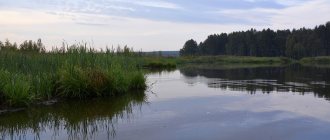
Of particular note is spinning fishing on a tributary of the Charysh - the Istok River, which is located near the villages of Priozernoye and the famous Korobeynikovo in the Ust-Pristansky district. In the absence of flooding of the Charysh floodplain with spring waters, starting in May I go fishing with a spinning rod on the Istok River, where I indulge my soul by catching pikes.
Pike can be caught in Istok all summer and autumn, it all depends on the water level in Charysh, and when it is very low there, the level in Istok also drops, and at the same time huge hordes of pike roll into Charysh. There is a lot of it there, sometimes it even jumps out onto the shore in pursuit of the fry.
For fishing here you will need at least a bucket of live bait and you won’t have to sit on the shore at all. On the ten girders set up, pike attacks will be very frequent.
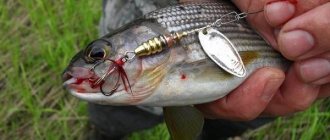
Pike is taken not exactly large, up to 1.5-2 kg, but often. The most catchy baits are twisters and vibrotails of light colors of medium size. During one such fishing trip, an average of 60-100 pikes are caught. According to my observations, there are not so many spinning fishermen.
Fishermen from the Altai Mountains and Barnaul travel to these places, despite long distances. The river is not wide, the bait should be thrown under the opposite bank or along the bank and made a quiet retrieve, rolling the jig with rubber along the bottom. On active pike days, it happens that pike take Meps Long No. 3 spinners. Crucian carp and roach are caught well with float rods.
Of course, there are difficulties with access to Istok after the flooding of the Charysh floodplain in which it is located. Even after the water flows back to the previous level, the road to the shore becomes dry after a couple of months. But it doesn’t matter if you have a boat, but there are few fishermen and a lot of fish. In this case, it is better to swim on rubber boats, and the bite is crazy, it gets to the point that your hand gets tired from the pikes.
Opposite the exit of Istok on Charysh (downstream) there is a good place Devil's Pit, in alignment with Istok, a huge pike takes here (on a twitch, in the retrieve too), but less often. The Devil's Pit has wonderful places for catching pike and pike perch using bait and bait.
Opposite the exit of Istok on Charysh (downstream) there is a good place Devil's Pit, in alignment with Istok, a huge pike takes here (on a twitch, in the retrieve too), but less often. The Devil's Pit has wonderful places for catching pike and pike perch using bait and bait.
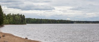
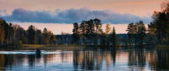
Charysh River
The Charysh River is the third most abundant river in the Upper Ob basin (after the Katun and Biya). It originates from the northern slopes of the Korgon ridge, 16 km from the village of Mendur-Sokkon (Altai Republic) at an altitude of 1800 m. The length of the river is 547 km, the area of the water basin is 22,200 sq. km.
In the upper reaches, the Charysh rushes between steep slopes like a typical mountain river, on average it calms down somewhat, and in the lower reaches it flows out into the plain in a wide channel. Everywhere, except for the very lower reaches, there are rapids and rifts.
From the village of Ust-Kalmanka (83 km from the mouth) navigation can be carried out during the entire navigation period. Above the village of Ust-Charyshskaya Pier, Charysh flows into the Ob.
Even under Demidov, the banks of Charysh were developed and populated by Russian settlers: miners, Cossacks, and Old Believers. On the banks of the Charysh there are the settlements of Ust-Kan, Charyshskoye, Krasnoshchekovo, Ust-Kalmanka, Beloglazovo, Bestuzhovo.
In the upper reaches of the Charysh there are unique places where its tributaries flow into it. They all come from the left side. Large tributaries of the Charysh flow from the Korgon and Tigiretsky ridges - the Kumir, Korgon, Inya, and Belaya rivers.
If Charysh itself is called a turbulent river, then its left tributaries are called “mad”. They have a large fall, and in large areas they flow between rocky shores. There are many small waterfalls in the upper reaches, the most famous of which is Spartak Falls on the Korgon River.
The mountainous part of the Charysh River basin, together with the surrounding ridges, is called Mountain Charysh. In the lower reaches, the Charysh basin is located on the treeless Pre-Altai Plain, which turns into the Priob Plateau. In the upper reaches, the slopes of the river are steep, and there are granite outcrops. Further, the slopes gradually decrease; in the last 25 km, the Charysh flows along the Ob floodplain. In the middle and lower reaches, a floodplain 2-7 km wide is developed, it is crossed by oxbow lakes, and in the depressions it is swampy.
In summer, the water temperature in Charysh in the lower reaches rises to + 20 degrees, in the upper reaches it remains cold. Freeze-up lasts from late November to early April. A significant part of the Charysh basin is occupied by forests. The slopes of the Korgon ridge are dominated by spruce and fir; higher up there begins a zone of high-mountain meadows with low but colorful herbs.
Weather in Charysh
The Mountain Charysh region has a temperate continental climate. At the end of winter and beginning of spring, avalanche danger is possible in the middle mountains of the surrounding ridges - Tigireksky, Koksuysky, Korgonsky. This is due to the fact that strong winds carry snow, and in some places a lot of it accumulates.
Winters here are mild, and summers are warm, not hot. The average temperature in January is -16 °C, in July +18 °C. But even in summer, night frosts and snowfalls are possible in the Alpine region. Accordingly, as you rise into the mountains, the temperature decreases and the wind strength increases.
What kind of fish is found in Charysh
The first thing that struck me was that the entire bottom was strewn with young grayling, lenka and eelfish. The electric rods were probably used or poisoned by something. Everyone was a little indignant at the chaos and scattered to fish in different directions.
I went upstream. I walked along the shore and along the water, about three kilometers. Everywhere the same picture. There are fry everywhere at the bottom. I tried to lure, catch with a Tyrolean, with a bulldozer. Complete zero Came to camp in the dark. Everyone was already cheerful. I started asking about the results of the fishing. Nobody caught anything. The locals were fishing with a float rod and told me that I wouldn’t catch anything with a spinning rod. We looked at the Tyrolean equipment and were surprised. They said that no one fishes with such gear. They often catch it with a balda, but it’s not the season to fish with it yet. We sat by the fire, had dinner and went to bed. Before going to bed, I set up a boat with flies and three mice on the river. The ship stood until three o'clock the next day without any result. We woke up around 6 o'clock in the morning. We drank tea and scattered along the river again. This time I went downstream. I walked down two kilometers. I didn’t miss a single meter of the river. I caught one haryusenka, 8 cm long, which I immediately released. At the bottom of the river there is the same picture - dead fish. By lunchtime I returned to camp. Everyone was already there. One of our guides was very happy and told me that he had caught a uskucha – that’s what they call lenka. I asked to see what he did. This lenok was at most 15 centimeters long. I suddenly didn’t want to fish anymore. 6 people caught only 4 fish in two days. In addition to the lenok, there are 3 more haryusenkas. We had lunch and our friends said that they would go to the village, which is not far from the river. When they left, we decided to go to Lake Teletskoye to rent a boat there and go fishing on the lake at the mouth of some river. When our “fishermen” arrived, we told them that we were leaving for Artybash. It seemed to me that they were even happy. I left them some of the food and “cookies”. I gave one of them 1000 rubles, because... I learned from conversations that he has 5 children, neither he nor his wife have a regular income. Sanya Brukh wanted to give them money too, but he only had euros. He gave me waders brought from Germany, but since I already had two of them, he asked if he could thank the men with them. I didn't care and he gave them the waders. After that, we packed up and left for the lake. And there is an emergency. The boat capsized and several people drowned. This happened on July 11th. All movements on boats, boats and other watercraft were immediately prohibited on the lake. Many rescuers, police, prosecutors, etc. arrived. We hung out on the shore and learned that 4 people had drowned. Several people were saved. Everyone was told that the depth where the accident occurred was 260-280 meters. While rescue operations are underway, all boat access to the lake is prohibited. After having dinner in one of the cafes, at about 10 p.m. we decided to go to the Swan River. While we were driving, a severe thunderstorm began. We arrived at the river around 24:00. There were several cars and tents on the shore. It was raining heavily. Several people were sitting under the tent. One of them approached our car. We asked him about the fishing results. He told us that they arrived in the afternoon and didn’t catch anything. The water has risen and is very cloudy, because... there were heavy rains.
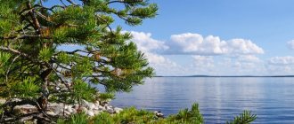
Rafting on the Charysh River on kayaks and catamarans: description
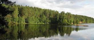
Charysh is the third most abundant river in the Upper Ob basin (after the Katun and Biya). It originates in the Altai Republic, not far from Ust-Kan, but flows mainly through the territory of the Altai Territory. Even under Demidov, the banks of Charysh were developed and populated by Russian settlers: miners, Cossacks, and Old Believers. The people here are friendly, the nature is beautiful, calm, although not without its effects - there are especially many caves and ancient mines in these places.
The Charysh flows between mountain ranges, but there are no rapids on it . The current is fast everywhere, especially when the water rises after rains; many rifts and riffles block the calm flow of the river. When rafting along the Charysh, you need to be especially careful when passing rocky outcrops and bends in the river; there may be pile-ups on rocks and stones that are hard to see from the influx.
The climate is sharply continental, the weather can change dramatically during the day, and it rains quite often. Summer temperature during the day is +20...30 °C, at night +10...20 °C.
The main pattern in the distribution of vegetation is the different zonation. The forest is mixed - pine and spruce adjacent to birch and aspen. Along the river valleys there are shrubs (currants, raspberries, ferns, etc.). In the river valley there are narrow fields and meadows.
The fauna is characterized by a mixture of typical taiga inhabitants. The most typical species for mountain taiga regions are squirrels, hare, fox, rodents, and traces of large wild animals are also found. Birds include woodpecker, nutcracker, crane, etc. Grayling is most often found in rivers and lakes. There are not very many blood-sucking insects (mosquito, midge, horsefly, tick). At the beginning of summer, there are a large number of ticks; by mid-July their number decreases significantly.
The beauty of the river is also evidenced by the fact that in 2003 V.V. HIMSELF was honored to visit it . Putin , who made a small rafting trip and fished on Charysh.
enter the route along the Chuisky and Ursulsky tracts to Ust-Kan, in Ust-Kan we turn into the Charysh valley, and our further path goes along Charysh.
The starting point of our rafting will be the mouth of the Kumir River; the first 300-500 meters of rafting will pass along the Kumir. In case of very high water (determined during the race) and a love of extreme sports (determined by the instructor based on the size of the participants’ eyes), it is possible to start the route 10-15 km upstream of the Charysh River. (the possibility of a higher start of the route is determined by the instructor)
Participants must be over 16 years old. The number of participants is from 8 to 22 people. Arrival to Barnaul, meeting in Barnaul at the hotel Kolos st. Molodezhnaya, 25. Article about Fishing in Altai.
Rafting program by day:
Day 1
From Barnaul our minibus leaves at 8.00 from the Kolos Hotel. On the way, check-in at the railway station and airport (9.00). Our journey will take 7-9 hours, along the way there will be a stop at a cafe for lunch. Our route passes through Gorno-Altaisk (possible arrival at Gorno-Altaisk airport), the village of Ust-Kan to the mouth of the Kumir River, where we set up camp, prepare a delicious dinner, get to know each other, and spend the night.
Day 2
We collect our ships, distribute the travel cargo, and begin our rafting. From the mouth of the Kumir River, Charysh has a width of 50-80 meters, a strong current, and many turns. You must immediately start working with the oar with all your strength, there is no time to roll in, and although there are no separate local obstacles on Charysh, the entire river up to the village of Charyshsky can be considered one continuous riffle without reaches, somewhere the current is a little quieter, somewhere stronger, but rafting on such a river requires constant attention and accuracy.
If the water is high and the group is prepared, it is possible to start the rafting a little higher, from the area of the village of Tyudrala. Above the mouth of the Kumir, Charysh is very small, 10-15 meters wide, but here is the most dynamic and interesting section of rafting, the largest drop of the river and the most difficult riffles. We get to the parking lot near the mouth of the Bolshaya Tatarka River in a good, convenient parking lot.
Day 3
Our rafting is becoming more and more fun and exciting. Charysh gradually accepts tributaries, the flow speed does not increase, but the river becomes much more powerful, especially if we started from Tyudrala. There are a lot of rocks along the banks, there are strong pressures on the steep banks on the river, and there are isolated stones in the riverbed. The clarity of the water is still amazing, and it will remain that way until the end of the route. We will end today at a parking lot below the mouth of the Sentelek River.
Day 4
Today we are entering the path of the “Presidential Rafting”. It was in this place that our Great Helmsman took his historic step of reconnecting with water tourism, or more precisely with rafting. The most beautiful landscapes and an unforgettable river await us. There is more water in Charysh, poured in from numerous tributaries, but the water is still as clear and clean as it was at the beginning of the rafting. There are more and more obstacles on the river, the rifts are becoming more and more extended, simple shafts and barrels appear, which, if desired, are easy to go around, or walk through them, getting a thrill and washing yourself in each shaft. We stop for the night near the village of Charyshskoye.
Day 5
Day. We are not sailing anywhere. We do a sauna, fish, swim, sunbathe, pick mushrooms and have adventures.
Day 6
In the morning we continue our “Presidential Rafting”. The river valley is expanding significantly, the mountains that surrounded us in previous days are moving apart. In the middle of the day, around the time of our lunch, the “Presidential” part of our route ends, we move on, but the river remains just as fast and clean. We park near the mouth of the Inya River.
Day 7
We continue our wonderful rafting along Charysh. There is even more water in the river, the mountains completely leave us and turn into gentle hills, but the speed of the flow in the river does not decrease. There are very few obstacles in the form of rolls and rifts and they are greatly simplified. We parked near a beautiful rocky outcrop.
Day 8
Today is our final day of rafting. Islands appear on Charysh, the river flows through several channels, but the flow speed does not decrease. The mountains are completely behind us, the river runs through the steppe, between gentle hills. After lunch, we approach the bridge in front of the village of Krasnoshchekovo, where we dismantle our ships and load into minibuses. The water part of our journey is over.
The estimated travel time to Barnaul is 5-7 hours; along the way there will be a stop for lunch/dinner at a cafe.
for children over 8 years of age to participate , accompanied by adults, on 4-seater catamarans or on 2-seater catamarans as a passenger (look-ahead)
Young people over 14 years of age, accompanied by adults, can participate in inflatable kayaks.
It is advisable to arrive/arrive in Barnaul the day before, because... upon arrival at 3.00 you will be slightly sleep-deprived and tired, and we will have a long journey to the beginning of our route. Estimated departure time of minibuses from Barnaul from Kolos at 8.00
It is possible to participate in the rafting on 4-seater catamarans or 2-seater inflatable kayaks. There are 2 instructors with the group on the route, so be prepared to make your own rafting line, following the instructor.
, please inform us on what type of vessel you would like to travel this route.
We merge the most fishy places in Altai. Fishing
Altai is an ideal place for fishing. The territory of Altai is more than 7 thousand lakes with a variety of fish. In addition, the wonderful natural landscapes themselves attract tourists from all cities of Russia.
Fishing in Altai can be planned at almost any time of the year. Local lakes are rich in various species of fish, which are found nowhere else except Altai lakes and rivers. For example, the grayling fish is found mainly in the foothills. This is due to the fact that grayling has special requirements for the oxygen content in water and the degree of water purity. Another unique species is taimen. Siberian taimen weighs more than salmon, but it is still less energetic in the fight. Fishing with a spinning rod for this type of fish is of great interest to anglers. The people of the Urals call taimen “red pike”. In addition to all of the above species, fishing in Altai involves catching trout, carp, and burbot. Many fish that are found in the waters of Altai rivers are truly large in size. Where to fish in Altai: – Ulagansky district, Boshkaus, Chuya, Chulyshman rivers – grayling. – Ulagan lakes – peled, trout. – Karatash lakes – trout – Shavlin lakes – grayling It is quite difficult to catch fish on Lake Teletskoye, but very experienced fishermen sometimes manage to catch grayling in the waters of Lake Teletskoye.
Altai is an ideal place for fishing. The territory of Altai is more than 7 thousand lakes with a variety of fish. In addition, the wonderful natural landscapes themselves attract tourists from all cities of Russia.
The best places for fishing in Altai in 2019
Russia rightly deserves its reputation as a great fishing power. You can fish in all federal districts. One of the best places for fishing and recreation is the Altai Republic, where there are many lakes and rivers, as well as the neighboring Altai Territory.
Katun River
Physiographic description
The source of Charysh is located on the northern slope of the Kogornsky ridge in the East Kansky region of the Altai Mountains, at an altitude of more than 2000 m. The mouth (the place where the river flows into the Ob) is located above the village of Ust-Charshskaya pier.
The river flows in an area with a temperate continental climate. Almost the entire pool is located in a forest area. Characteristics of the flow of the Charysh River in the Altai Territory
| description of the area | flow speed (m/sec) | |
| top part | mountain | 3—4 |
| middle part | mountain | 2—2,5 |
| Bottom part | plain (slope 0.12—0.76%) | 1—1,5 |
The mountainous part of the river is limited by:
- from the north - the Beshchalaki ridge;
- from the south - Gorgonsky and Tigerinsky heights;
- from the east - Terektinsky ridge.
Throughout the entire length of the river (except for the very lowlands), there are differences in depth. The last 25 km of the channel pass along the Ob floodplain.
On the Pre-Altai Plain, Charysh forms a river valley with four steep macrobends. Below the confluence of the Sentelek tributary, the river has a wide swampy floodplain up to 1.7 m high. The width of the floodplain varies from 2 to 7 km.