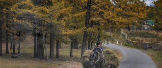
Geography of the Stavropol Territory
The area of Stavropol is 66.16 km², it includes 26 administrative districts with a population of 2.8 million people, of which 58.36% are urban (data as of 01/01/2017).
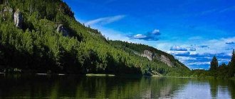
The climate of the region is temperate continental. The terrain is difficult. The central part is occupied by the Stavropol Upland, which in the south connects with the foothills of the Greater Caucasus, in the east it smoothly flows into the Terek-Kuma Lowland and into the Azov-Kuban Lowland in the west, and in the north it connects with the Kuma-Manych depression.
In the foothills, one can distinguish Pyatigorye, a volcanic region with numerous peaks. The maximum height is observed in the Kislovodsk region and reaches 1603 meters above sea level. The smallest peak is located in the lower reaches of the Kuma River. Its height is only 6 meters.
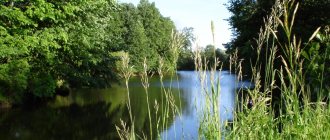
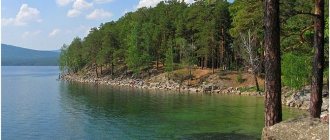
The rivers, lakes and mountains of the Stavropol Territory are original and picturesque. There are 130 mineral water springs in the Stavropol region. The water resources of the region are not only rivers and lakes created by nature, but also man-made reservoirs, ponds and canals, which are used to moisten arid steppe lands.
Paid fishing
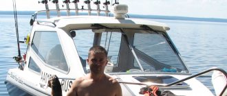
If we talk about paid fishing in the Stavropol Territory, then we can’t help but talk about “Popovsky Ponds”. This is a complex of fifty reservoirs covering an area of 500 hectares. The reservoirs are stocked with fish several times a year, so a rich catch in these places is guaranteed.
There are lesser-known paid reservoirs of the region, but no less attractive. This is a lake near the village of Novoulyanovka, ponds in the Novotroitsky district and a pond near the village of Krasnoe.
Paid ponds in the Stavropol Territory are quite accessible. Upon entry you can purchase gear and bait.
Rivers of Stavropol
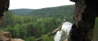
The rivers of the Stavropol Territory belong to the basins of the Caspian and Azov seas. Due to the arid climate in most of the region's lands, the density of the river network is insignificant and unevenly distributed. The rivers are most densely located in the foothills, and to the east and north their number decreases significantly. What rivers are there in the Stavropol Territory?
There are just over 200 rivers and rivulets in the Stavropol Territory. Most of them are small rivers. The length of such rivers is from 101 to 200 km with a drainage area from 1000 to 2000 km². The rivers flowing in the eastern part of the region contain a large amount of mineral elements, which is associated with the salinity of the local soils.
The list of rivers of the Stavropol Territory can be divided into two parts: rivers belonging to the Azov-Black Sea basin, and those belonging to the Caspian Sea basin.
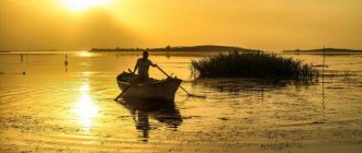
Fishing in the Stavropol Territory
Fishing in the Stavropol Territory is characterized by effectiveness, which brings fishermen a lot of useful emotions. Here it is not a problem to catch large fish without serious effort. In this regard, this region is increasingly attracting amateur fishermen, since it is not a problem to find a promising place here. This article will tell you exactly where and in which bodies of water the most active fish bite is.
Lakes of the Stavropol Territory: treatment, fishing and amazing scenery
Fresh and salty, little-known and famous, natural and man-made - in the list of lakes of the Stavropol Territory, which contains about forty names (and together with reservoirs, about a hundred), you can find reservoirs that are very different in their characteristics and origin. There are no mountain lakes as such in the Stavropol region, but Mount Mashuk is famous for its stunning reservoir of karst origin, located at the bottom of the cave. Lake Proval today is considered the most attractive in terms of tourist interest, while other lakes gather seekers of healing mud and avid fishermen.
Competition to the Dead Sea: healing waters, salts and mud of Stavropol
The Stavropol region abounds in salt water bodies. Some of them don’t even have unique names: that’s why they are called Salty. The salt lake in the Aleksandrovsky district, like its namesake from the Krasnogvardeisky district, is a source of healing mud, which is even compared to the famous mud of the Dead Sea. Another Salt Lake of Stavropol is located near Svetlograd and has a second name, Lushnikovskoye. There is evidence that the legendary S.M. treated his soldiers here during the Civil War. Budyonny.
But the most famous healing lake in these places is Tambukan. Located on the border of Kabardino-Balkaria and the Stavropol Territory, Lake Tambukan bears the name of the great Kabardian prince: it is named after one of the founders of the ancient Tambiev family, who, according to ancient legends, was buried on the shore of the reservoir. There are several hypotheses about the origin of Tambukan. Some researchers are inclined to consider it a remnant of a disappeared sea, some consider it the product of underground springs, some are sure that this is the former bed of the Etoka River flowing nearby. But be that as it may, the main asset of the lake is the tons of mud lying on its bottom. Tambukan mud is delivered to almost all health resorts of the Caucasian Mineral Waters and is used for medical purposes in accordance with the main therapeutic profile.
Fishing on reservoirs and lakes of the Stavropol Territory
Almost all reservoirs of the Stavropol region are inhabited by different species of fish, so people from other regions of Russia also come here to fish. Lake Dovsun and the Chogray reservoir are popular in the Arzgir region. Sengileevskoye Lake in the Stavropol Territory is extremely rich in fish, although, in essence, it is also a reservoir that supplies the regional center with fresh water. Previously, the lake was not very deep and had a different name (it was called Rybny), but in 1958 a dam was built, the water level rose and now the depth of the reservoir even competes with the Sea of Azov.
A number of lakes in the Stavropol Territory are part of the Proletarsky Reservoir, also famous among tourists keen on fishing. This is Lake Velikoye, located on the border with Kalmykia, as well as the remains of an ancient reservoir that connected the Caspian and Black Seas, the relict lakes of the Stavropol region Lysyy Liman, Beloe, Manych, Manych-Gudilo, Maly Manych;
Recommendations
Arriving in the Stavropol Territory, any lover of sitting with a fishing rod will be able to find a body of water that will fully meet his expectations and preferences. However, it should be borne in mind that the road from an amateur fisherman to a poacher is short for Stavropol residents . All you have to do is take a network with you, for example. It is included in the list of prohibited attributes that instantly make any fishing illegal. The same list includes toxic and explosive substances, all kinds of traps, firearms and devices running on electric current. In the Stavropol region it is prohibited to fish using nets along the path of fish movement. Nets, scarves, as well as traps and piercing objects are strictly prohibited. Restrictions even apply to fishing rods - there should not be more than 10 units per person, and no more than 5 crayfish traps.
Anyone who catches crayfish with their hands will also be declared a violator of the law - this is considered illegal in any case (both if you pull them out of a ford and if you dive).
When fishing, it is advisable to have a ruler at hand - the fish should not be less than the minimum established by the regulations. It is declared within the following boundaries:
- catfish - 60 cm;
- pike perch - 35 cm;
- bream and carp - 24 cm;
- pike and carp - 30 cm;
- chub - 22 cm;
- barbel - 20 cm;
- tench - 17 cm;
- ram - 16 cm.
The minimum size of crayfish is 9 cm.
Watch a video about fishing in the Stavropol Territory.
Source
Lake Dadynskoye
The height above sea level is 13 meters, and the area is 31.5 square kilometers. Depth - 2 meters.
The lake is located on the territory of a xerophytic semi-desert steppe. The steppe is distinguished by individual low, gently undulating hills and shallow depressions occupied by salt marshes, swamps and lakes. The banks are low and steep, where dense thickets of reeds grow.
Common breeding species in this area include: little and great grebes, great cormorant, Dalmatian pelican, great bittern, yellow heron, great and little egrets, gray heron, red-headed heron, mallard, gadwall, shoveler, red-billed pochard and many others. A large number of birds concentrate here on migration and wintering. Fishing is also developed on the lake.
Coordinates: 45.26305600,45.08972200
What lakes are there in the Stavropol Territory:
Salt Lake
The salt lake in the Stavropol Territory has attracted people since the twentieth century. Driving past it, notes were made that in the summer the reservoir noticeably becomes shallower. From a distance it seemed that there was 2-3 centimeters of water below, but when we got closer, it turned out that it was just the bottom. Such crystals began to be called brines. They form at a low speed, so until the lake is filled again, they have time to squeeze out the salt minerals. As the water level rises, the crystals dissolve. The lake also has healing mud. One of the best in the Caucasus. It has been scientifically discovered that this mud has a beneficial effect on the respiratory system, joints, and human skin.
There are no underwater animals living here. Due to the unusual percentage of salts. Lousy Lake is a nature reserve in the Stavropol Territory. Its goal is to preserve and restore the ecological structure of the lake and expand the number of living individuals. Most of the animals living on the territory are listed in the Red Book. Lousy lake is located in the Shpakovsky district. It has no drains and is formed naturally. The name was given by local historian Gnilovsky, who noticed a cluster of insects (water fleas) on the territory of the reservoir. Now the area of the lake is inhabited by water hens, bitterns, and coots. All of them are little known because they are on the verge of extinction. However, people and the authorities are trying with all their might to preserve the flora and fauna of Lousy.
Lake Dadynskoye
Lake Dadynskoye, Stavropol Territory, consists of three different bodies of water. Each of them has its own name (Big, Small and Southern). The lake itself is surrounded by marshy places that are difficult to navigate. Dry times entail drying out of Dadynskoye. In spring and autumn it takes runoff from an artesian well, rain and precipitation. Reed thickets have spread around the reservoir. On the ground you can find wormwood, wheatgrass, and feather grass. A special feature is that in summer there is a massive settlement of lakeside birds (little and great grebe, cormorant, bittern, yellow heron and others). They all build nests near water. On the territory you can find rare species of reptiles: patterned and pallas snakes.
Wolf Lake
Wolf Lake in the Stavropol Territory originates in the Novoselitsky district. Local residents of the Stavropol Territory call the lake the Wolf Gate. This is an artificially created reservoir. Formed by blocking one of the rivers. At the moment, the Golden Sands resort and hotel complex has opened in the coastal zone.
Petrovskoye Lake
Petrovskoye Lake in the Stavropol Territory is another body of water. It is formed in the village of Petrovsky district. The accommodation itself is on a hill at the foot of Mount Kutsai. Since 1999, a reserve has been located here, consisting of two parts. One of them is the Petrovskoye salt lake in the Stavropol Territory.
Lake Kravtsovo
Lake Kravtsovo in the Stavropol Territory is one of the most ancient. Researchers claim that it was formed during the glacial period. The origins of its name are also unknown. Some believe that the reservoir is named after the surveyor Kravtsov, who conducted research here, others talk about the connection between the ancient owners of the territory - the Kravtsov family.
Lake Bald Liman
Lake Lysyy Liman stretches along the border of the Stavropol Territory and the Republic of Kalmykia. The water in the lake is salty; it is located in the central part of the Kuma-Manych depression, 13 kilometers from the village of Kevyudy. Today Bald Liman is located at 17 meters above sea level, the lake is 8 kilometers long and 2.6 kilometers wide. But in ancient times, on the site of a relict lake, there was a gigantic strait between the Caspian and the Black Sea - the remnants of this ancient strait are the numerous lakes of the Manych group, including Lysy Liman.
The Manych River flows into and out of the flowing lake; the size of the territory it occupies varies depending on the waters that feed it, the average is 800 hectares. Bald Liman is surrounded by flat terrain overgrown with steppe grasses, and the lake vegetation is represented by traditional cattails, reeds, and reeds.
Bald Liman is a place loved by fishermen; commercial fisheries (pike, pike perch, and perch) are also carried out here. More than seventeen species of birds live on the lake.
Coordinates: 45.83741100,44.05002600
The longest rivers of Stavropol
List of the largest rivers in the region by length!
Kuma
The source of the Kuma River is located on the rocky ridges of the Karachay-Cherkess Republic. This is a wayward, muddy, mountain river with a stormy current and many whirlpools. The Kuma carries its waters in clayey banks up to 50 m high. Hydrogen sulfide mineral springs can be found in the river valley. The river is fed by groundwater and precipitation. There are catfish and other fish in the river. It’s not every year that Kuma reaches the Caspian Sea. In a dry year it dries out earlier. The river is used to irrigate the Kum Valley.
The length of the river is 802 km, in the Stavropol region – 584 km
Egorlyk
The source of the river is on Mount Strizhament. Here many springs join into streams that form a river. The river water is initially muddy and bitterly salty. The right slope of the river is higher. The abundance of water in the Yegorlyk River increased significantly after the construction of the Nevinnomyssk Canal in the middle of the 20th century. Currently, Egorlyk is part of the Kuban-Egorlyk irrigation system.
The length of the river is 448 km, in the Stavropol region – 284 km
Kalaus
It originates on Mount Bryk. Maikop clays are located nearby. For this reason, the water is cloudy, salty, and not suitable for drinking. The river is fed by melting snow, springs and rain. The banks of the Kalaus are steep, steep, reaching a height of 15 m. Kalaus flows into the Western Manych on the left and belongs to the Azov Sea basin.
River length – 436 km
Manych
The river originates in Kalmykia at the confluence of the Kalaus and Eastern Manych rivers. It flows into the Don River near the village of Manychskaya. Manych water has a high degree of mineralization. Above-water vegetation cannot develop in such water. The salinity of the water decreased after the supply of water from the Kuban River in 1948. The river is fed mainly by melting snow. The river is used to irrigate fields. Shipping and fishing are developed.
The length of the river is 420 km, in the Stavropol region – 115 km
Kura
The Kura branches off from the Malki River. The river is shallow. Near the Kura River there is the Glubokoye tract, a favorite vacation spot for the local population. Biologists explored this area for four field seasons. Ten species of endangered plants have been found. In a small area, the Kura is the border between the Stavropol Territory and Kabardino-Balkaria. The mouth of the river is lost in the sands of the Nogai steppe.
River length – 198 km
Gorky Beam
It originates from a small spring in the Georgievsky district. The banks of the river are heavily overgrown with reeds and reeds. Wolves, wild boars, foxes and muskrats live here. It flows into Lake Beloye. In the 50s of the 20th century, the river almost disappeared completely due to the unsuccessful construction of the Nogai waterway. The water from the semi-stagnant river began to recede at high speed. All the fish died. To save the river, a retaining dam was urgently erected.
Lake Kravtsovo
The basin of the lake is oval in shape. The height above sea level is 550 meters, and the area is 0.68 square kilometers.
The reserve is hydrological, designed to preserve and restore the ecological system of Lake Kravtsovo, preserve the flora and fauna of the relict wetland ecosystems of the forest-steppe. The vegetation is typical of both open natural reservoirs and swamps. The water surface is a resting place for migratory birds, and the eastern and southern parts are nesting places for waterfowl. The bottom sediments contain peat and silt with spores of plants that grew here in past centuries. Also found there were two species of diatoms typical of peat bogs: Tabellaria flaccata and Eunotia minor.
Coordinates: 45.01055600,41.82361100
Salt Lake
The lake basin has an oval shape. The height above sea level is 10 meters, and the total area is 34 square kilometers. The bottom of the lake is flat. It is covered with a thick layer of silt (up to 9 meters), the upper part of which, up to 10 centimeters thick, has healing properties. The depth of the reservoir during the period of maximum filling reaches a maximum of 60 centimeters. Salt Lake is fed by rain and groundwater.
Lushnikovskoye Lake
Like Salt Lake, Lushnikovskoye is a relic, that is, the remnant of a reservoir that connected the Caspian Sea with the Black Sea in prehistoric times. Lushnikovskoye has the same properties as Salt Lake.
Zoological reserve. Established for the purpose of preserving and reproducing rare and valuable species of wildlife. This is a nesting place for birds, as well as a resting place on their migration route. The fauna is represented by mammals (black muskrat, raccoon dog, fox, brown hare), birds (avocet and stilt sandpiper, which are listed in the Red Book of Russia, gray crane, mallard, gray duck, ogre, mute swan, teal -whistlebird, teal, bittern, heron, waders, gray partridge, pheasant).
Coordinates: 45.27066100,42.84951100
Sights of Stavropol
Monument Guardian Angel of the City, Stavropol, Russia St. Andrew's Cathedral, Stavropol, Russia German Bridge, Stavropol, Russia Stavropol State Historical, Cultural and Natural Landscape Museum-Reserve, Stavropol, Russia Museum-Estate of V.I. Smirnov, Stavropol, Russia Monument to Ermolov, Stavropol, Russia
Lakes of Russia
Warm lakes - Lake Skazka, Baikal, Russia White Lake, Vologda, Russia Notozero, Murmansk, Russia Boarding house "Zerkalnoye Lake", Leningrad region, Russia Lake Piyavskoe, Saransk, Russia Lake Hulguzi, Leningrad region, Russia
Lakes of the world
Lake Mansarovar, Tibet, China Lake Khecheoparli, Sikkim, India Lake Uureg, Ulaanbaatar, Mongolia Lake Borovoe, Borovoe, Kazakhstan Lake Heviz, Heviz, Hungary Lake Stymphalia, Corinth, Greece Lake Vermilion, Banff, Canada Lake Medicine, Jasper, Canada Lake O'Hara, British Columbia, Canada Spider Lake Park, Parksville, Canada Quesnel Lake, British Columbia, Canada Lake Charleston Park, Ontario, Canada
Source
Fishing, hunting, active recreation on the lakes of the Stavropol Territory
The lakes of the Stavropol Territory are few in number, but rich in luxurious fish. The location of the region in the watershed of the Caspian and Black Seas determines the modest number of lakes in the region. There are only 38 of them in the region. Moreover, many lakes are filled with salt water or overgrown with marshy plants. Despite this, the Stavropol Territory is able to boast the best varieties of commercial fish that can be caught with a regular fishing rod. Including the lakes of the Stavropol Territory, they are ready to offer fishing fans the opportunity to catch such unique varieties of fish as grass carp, carp, bream, and pike perch. It’s even easier to catch silver carp, ram or crucian carp. Only here it is easy to catch the commercial fish trout, which is comparable in quality only to salmon.
Today fishing in the Stavropol Territory is possible in almost every lake in the region. Including holiday homes and sanatoriums, ready to welcome lovers of “quiet hunting”, are located on the shores of lakes Lysy Liman, Kurskoye, Chograyskoye, Tambukanskoye, Manych-Gudilo. There are 58 reservoirs ready to welcome fishermen on the banks. When going fishing in the Stavropol Territory, you should pay attention that fishing in many lakes is prohibited from April 1 to the end of May, when commercial fish species go to spawn.
Novotroitskoye Lake
The artificial reservoir got its name from the nearby Cossack village and the Novotroitsk hydroelectric power station, the oldest in the Stavropol Territory. After the dam of the state district power station blocked the river valley. Yegorlyk reservoir area reached 18 square km. Dozens of departmental recreation centers have been built on the shore of the lake, but there are also places for tent camps for local fishermen. The base areas are landscaped and you can find:
- brick buildings and wooden houses;
- beaches cleared of algae;
- billiard rooms;
- bars;
- bath complexes;
- fishing bridges.
The city beach of Solnechnodolsk on the shore of Lake Novotroitskoye does not differ in special amenities. Vacationers will find only regular changing rooms here.
Fishermen often stop in the villages of Rodionov and Smykov, where the fish are not scared away by vacationers.
Thanks to warm water, the pond does not freeze.
How to get to Novotroitskoye Lake
To get to the lake in the Stavropol Territory, the fastest way to travel 76 km from the capital of the region is by car. Having left Stavropol along the highway “07R-041”, you need not to miss the turn onto the road “07K-036” leading to the Izobilnensky district of the Stavropol Territory. This highway will lead you to the village of Novotroitskaya, where you can turn onto several roads to Solnechnodolsk, recreation centers . You can get to the villages of Rodionov and Smykov from other regions of the Stavropol Territory and Armavir along local roads through the village of Kamennobrodskaya and the village of Ravninny. From the capital of the Stavropol Territory to the village of Novotroitskaya you can get by bus from the central bus station, Northern bus station. Tickets for buses departing twice an hour cost 218–265 rubles.
What to see nearby
In young Solnechnodolsk there are no historical or architectural monuments. In the vicinity of the village of Novotroitskaya you can see the natural monument “Stone Chaos”, the wooden Church of the Virgin Mary, and the horse farm in Staroizobilnaya.
Also, get discounts from TravelAsk and bonuses from partners:
- Buy car products at discounts using “Wheels for Free” promotional codes.
- Labyrinth promotional codes allow you to save significantly on the purchase of books and stationery.
- Buy modern electronics and accessories at discounts using the Svyaznoy promo code.