Free fishing in the Bryansk region
In the Bryansk region there are a large number of different reservoirs where you can have excellent fishing, both in summer and winter. This activity is loved by many local residents; besides, the lakes, rivers and ponds in this region are clean. Fishing in the Bryansk region is distinguished by its diversity, including due to the specific geographical location of the region, which predetermined the presence of many different bodies of water. The region is located in the watershed of two large rivers - the Volga and the Dnieper, which already means great opportunities for your favorite hobby. And these possibilities are fully confirmed by the actual situation, since fishing in these places is a pleasure.
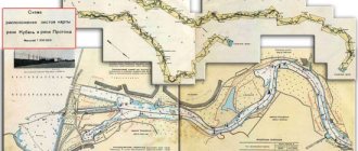
There are 125 rivers in the region, and their total length is over 9,000 kilometers. The network of these rivers is branched and unevenly distributed throughout the region. Most of the rivers pass through the central and eastern parts of the region, and almost all of these reservoirs belong to the Dnieper River basin. Rivers belonging to the Oka basin flow in these same areas.
Here are the TOP 10 best places where you can fish for free in the Bryansk region:
Desna River
Description, what kind of fish is found, how to get there:
Desna is considered one of the largest in the region. Taking into account the strong current, fishing techniques in this river have their own characteristics. Thus, local fishermen mainly use gear with weights. The topography of the bottom of the Desna is extremely heterogeneous, and deep holes give way to sandbanks. Common fish include pike, ide, pike perch and some others. There is also bream in the river, but the strong current creates some difficulties when catching it. As a rule, fishermen place their boats near the holes or fish directly from the shore. Spinning rods are used to catch pike, chub, and perch. At the same time, the pike is found mainly in places with a weak current, and the chub chooses places on the rifts. Fish enter the Desna River mainly during floods from the Dnieper.
GPS coordinates: 53.39143, 33.92937
Iput River
Description, what kind of fish is found, how to get there:
Iput is a medium-length river flowing through the region. The most attractive areas for anglers are the areas in its lower reaches, near the village of Starye Bobovichi. The average depth of the reservoir in the riverbed is 3 meters, and in places of pits it can reach 7 meters.
Successful anglers can catch medium-sized catfish. Local fishing connoisseurs often call Iput the ulcer river, and this fish is caught here in various ways - from a feeder to an ordinary crust of bread in the form of bait and a long rod, with which it is much easier to retrieve. The reel installed, as a rule, is inertia-free, since with its help it is much more convenient to cast equipment. In this case, the equipment needs to be released quite far - over 50 meters.
GPS coordinates: 52.89464, 32.0365
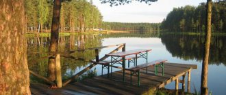
Lake Shumovets
Description, what kind of fish is found, how to get there:
The lake is located 35 km southeast of Bryansk, and only 2 km from the Kyiv highway. Fishing on this lake is one of the most enjoyable activities, thanks to the remarkable intensity of the bite and the high density of fauna. These qualities have made the destination popular among lovers of fishing tourism.
When fishing, you should use the inflatable boat you brought with you; fortunately, getting to the lake by car is not difficult. You should use regular oars, because motor boats make a lot of noise when moving, which negatively affects the intensity of the bite. It is better not to take metal punts when rowed, as they are also quite noisy.
Fishing from the shore is difficult due to the steep, uneven slopes, densely overgrown with bushes and young animals. However, with a lot of desire and remarkable patience, you will find a flat area for fishing.
GPS coordinates: 53.05777, 34.55611
Lake Belogolovl
Description, what kind of fish is found, how to get there:
The village of Belogolovl is located 60 km northwest of Bryansk. Nearby is the lake of the same name. The most suitable season for fishing on this lake is from early May to mid-June. Local crucian carp bite especially intensively at this time of year. However, fish are caught here all year round.
The lake is also home to ruffes, tench and carp. There is much less pike in the reservoir, however, it has an impressive size. The best places on Lake Belogolovl are those areas where deep streams flow into it. Locals prefer a medium to long length float rod. The most popular among the Aborigines is catching roach.
Winter fishing on Lake Belogolovl involves catching large perches, which is absolutely unattainable in the summer. Sometimes you come across individuals weighing half a kilo, which is a good result, given the peculiarities of the weight gain of these fish.
Construction of ponds and reservoirs in Bryansk
Turnkey pond Fish pond Pond in Bryansk Turnkey pond
The specialized company Aquais carries out the construction of ponds and reservoirs in Bryansk of any complexity and purpose. The company’s capabilities allow us to implement even the most daring design solutions and build artificial reservoirs of various configurations and styles. The use of modern materials and the use of the latest technologies creates all the conditions for the pace of construction of ponds and reservoirs in Bryansk to be as high as possible with a consistently high quality of work.
Today, many companies offer their services for creating artificial reservoirs. There are many offers, but the quality also varies greatly. You can often find cases where materials are used whose quality leaves much to be desired, equipment from unknown manufacturers is used, and outside specialists are invited. All this, of course, cannot but affect the quality of the resulting reservoirs. Such ponds may be cheap, but these savings are imaginary. After all, a low-quality pond means unnecessary costs for its maintenance and repair.
Satellite map of Bryansk region
Bryansk region is one of the central regions of Russia, which is located on the border with two states - Belarus and Ukraine. The administrative center of the region is the city of Bryansk. The largest regional cities are Novozybkov, Klintsy and Dyatkovo.
The pleasant temperate continental climate of the Bryansk region is characterized by cold winter months and warm summer months. The average annual temperature varies within +4.5. +6C. July is the warmest month of the year. Its average temperatures in the region are +18. +19 C. The coldest month is January, when the thermometer averages -7. -9 C. One of the main attractions of the region is Pokrovskaya Mountain in Bryansk, on which a Kremlin with wooden walls has still been preserved and stands to this day.
Historical and architectural monuments can be seen in the ancient cities of the region. For example, in the city of Trubchevsk. While in this locality, you should definitely visit the Trinity Cathedral, Kamenitsa, Sretenskaya and Ilyinskaya churches. This city is one of the most unique cities in Russia, because almost every building in it breathes history.
There are also protected areas in the Bryansk region. One of them is the Bryansk Forest, which is located on the banks of the Desna and Nerussa rivers. This reserve is unique in that its symbol is the black stork. This bird is very rare and can only be seen in deep forests.
There is another interesting place in the village of Krasny Rog. This is a literary museum of the writer Tolstoy, by visiting which you can better learn about the work and life of this great man. www.russ-maps.ru
Bryansk region - districts on the map
- Brasovsky district
- Bryansk district
- Vygonichsky district
- Gordeevsky district
- Dubrovsky district
- Dyatkovsky district
- Zhiryatinsky district
- Zhukovsky district
- Zlynkovsky district
- Karachevsky district
- Kletnyansky district
- Klimovsky district
- Klintsovsky district
- Komarichsky district
- Krasnogorsk district
- Mglinsky district
- Navlinsky district
- Novozybkovsky district
- Pogarsky district
- Pochepsky district
- Rognedinsky district
- Sevsky district
- Starodubsky district
- Suzemsky district
- Surazhsky district
- Trubchevsky district
- Unechi district
| № | Locality | Subject of the federation | Coordinates | Stations |
| 1 | Bryansk | Bryansk region | 53.2433, 34.3637 | 3 |
| 2 | Novozybkov | Bryansk region | 52.5367,31.9332 | |
| 3 | Klintsy | Bryansk region | 52.7533, 32.2330 |
On the border with Ukraine and Belarus is one of the central regions of Russia - the Bryansk region. If you look at a map of the Bryansk region from a satellite, you can see that this region has significant forest planting areas. On the territory of the region there is a unique protected area of the Bryansk Forest - one of the main attractions of the Bryansk region.
The Bryansk region is located on the banks of the Desna southwest of the Russian capital. A map of the Bryansk region by region clearly shows which states abroad and entities within the country it borders with.
- From the north – Smolensk region;
- From the west - Belarus;
- From the east - Kaluga and Oryol regions;
- From the southeast - Kursk region;
- From the south - Ukraine.
Significant areas of the Bryansk region are occupied by forest belts and nature reserves. This is confirmed by the map of the Bryansk region, the outline of which represents a rather sparse population. Therefore, in terms of tourism, the Bryansk region is most often considered as an active hunting zone.
The population living in the region is more than 1 million 260 thousand people. Most of them are city residents and only 1/3 of all residents live in villages and villages. The region is predominantly inhabited by Russians, with a small number of Ukrainians, Armenians, Jews, Belarusians and Gypsies.
The districts on the map of the Bryansk region, the number of which is 27 municipal districts, are located west of the administrative center - the city of Bryansk. The total area of the region is 1860 km2.
Districts of Bryansk region on the map
A map of the Bryansk region with cities and villages clearly makes it clear what this border region is like. On its territory there are 7 urban districts and more than 220 rural settlements. One of the main places where tourists come with interest is Pokrovskaya Gora, which is located in the city of Bryansk. The log Kremlin, built several centuries ago, has survived to this day and is marked on a detailed map of the Bryansk region.
Another historically attractive place is the house-museum of the classic Leo Tolstoy. It is located in the village of Krivoy Rog. Visiting tourists and connoisseurs of classical literature come here to get even better acquainted with the writer’s work and his life.
Unique architectural monuments have been preserved in the ancient city of Trubchevsk. The walls of each building here are not only the work of talented architects, but also proof of the unique history of Rus'. Ilyinskaya and Sretenskaya Churches, Trinity Monastery - you can find these architectural and historical monuments on the map of the Bryansk region with villages.
In 1986, several areas were contaminated with long-lived radionuclides after the Chernobyl accident:
- Klimovsky;
- Klintsovsky;
- Novozybkovsky;
- Surazhsky;
- Krasnogorsky.
More than 16% of the population lived in the infected zone.
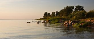
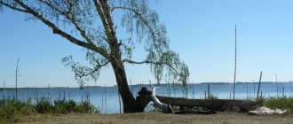
Lake Bezdonnoe
Lake Bottomless. Bryansk region.
A natural monument of the Bryansk region - Lake Bezdonnoye - is located near the village of Staroye Lavshino, Zhukovsky district, in a specially protected area, in a state natural reserve with an area of 77 hectares, of which 22 are occupied by the lake itself.
The reservoir of karst origin is bordered on three sides by old mixed forests with a predominance of spruce, ash and oak, and in the immediate vicinity of the water it is framed by a lace of alder and willow trees. The reservoir looks unusually picturesque, and its fish wealth attracts fishing enthusiasts to it.
Among the many lakes in the Bryansk region, Bezdonnoe is the youngest and least susceptible to overgrowth, although this trend is already emerging. The water in it is transparent and clean, and the depth in many areas exceeds twenty meters. The bottom is lined with a thin layer of silt. The smooth coastline outlines a smooth oval, without forming large bays, capes or peninsulas.
Despite the high location of the territory, approximately two hundred meters above the surface of the world's oceans, the area around the lake is in many places covered with swamps in which rare plants grow, two of which are listed in the regional Red Book. The lake is not rich in aquatic vegetation, which is represented by floating pondweed, yellow capsule, cattail, reed, sedge and two or three other species.
Surrounded on three sides by forests and swamps, in the south the lake has an equipped sandy beach with a flat bottom at the beginning of the descent and a sharp, steep slope a short distance from the shore.
It is prohibited to use boats and motor boats on the territory of the protected lake, but recreational fishing, picking mushrooms, berries and eco-tourism are allowed.
Lake Bezdonnoye is chosen not only by fishermen, but also by those who like to swim in warm and crystal clear water in the hot summer. Such vacationers choose the southern coast with an equipped beach. The roads to the lake are not of very high quality, but the “savages” still get to the coast. There are no problems with dead wood for fires and drinking water, but you should remember the status of the reserve and not build new fire pits.
Lovers of natural beauty and picturesque landscapes, having enjoyed the views of Bottomless, can visit the nearby Bechino, Svyatoe, and Orekhovoye lakes and the Carp Pond located to the south. All three lakes, like Bezdonnoe, are regional natural monuments, habitats of rare plants and rare animals. The floodplain lakes Bechino and Orekhovoye are known for thickets of water chestnut or bagel, the white fruits of which taste like chestnuts.
The most beautiful object is the Holy Lake, but approaches to it are difficult due to the high swampiness of the area. Those who manage to get there enjoy the scenery and fishing in clear but reddish water. The lake is surrounded by numerous rumors about UFOs and all sorts of evil. There is a legend about a church sunken in the lake, from which light emanates from the bottom of the lake at night.
However, the entire Zhukovsky district is favored by unidentified objects that visit the surrounding area in the form of chaotically, rapidly and silently moving fireballs (with or without legs), cigars and falling objects of unknown origin. The Zhukovka area has its own anomalous forest clearing and Moss swamp - a habitat for ghosts at the site of great battles of the Great Patriotic War and strange luminous balls rising from the ground into the sky. At the bottom of the Bottomless, scuba divers found a strange object, after which the military blocked access to the reservoir for several years.
Zhukovsky district is famous for the village of Ovstug - the birthplace of F.I. Tyutcheva. His museum-estate operates there, a monument to the poet has been erected, and a park that dates back several centuries is maintained. Near the western border of the village, archaeologists found a settlement dating back to the fifth century BC.
The oldest in the area is the former city, and now the tiny village of Vshchizh, known since the eleventh century. The city was completely destroyed during the Tatar-Mongol yoke. Excavations carried out in the surrounding area and on its territory have yielded interesting results. In the “Treasured Mound” in the center of the village, the remains of an ancient brick temple with twelve columns, a gallery, church attributes and a crypt were discovered, in which the skeleton of a man of enormous stature was buried, which is attributed to Prince Svyatoslav, the son of Vladimir, who ruled in the city of Vshchizh in the mid-twelfth century Chernigovsky.
When choosing Lake Bezdonnoye and its surroundings for your vacation, you can be sure that your vacation will be interesting and eventful!
Map of the Bryansk region with cities and villages
More detailed information about the location of settlements can be found on Yandex maps of the Bryansk region. Here you can determine the location of large regional centers, such as:
- Bryansk;
- Novozybkov;
- Trubchevsk;
- Mutilation;
- Dyatkovo;
- Klintsy.
They are connected by the largest highways, which are indicated in detail on the road map of the Bryansk region. For tourists who travel through the central part and southwest of Russia, such a map is an indispensable assistant.
The Bryansk region is crossed by 5 federal highways. Highways pass through 60 cities and towns and more than 200 railway sidings. The road routes of the Bryansk region on the map total more than 18,000 thousand km, connect regions of the region, and provide access to the borders with neighboring states.
The railway connection is also not only a connection between the region and other constituent entities of Russia, but also an outlet abroad. The railway map of the Bryansk region roads is presented in detail and gives a clear idea of the number of stations and directions. Railways stretch over a distance of more than 1,100 km, and suburban traffic is developing.
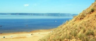
Lakes of the Bryansk region
On the territory of the Bryansk region there are 49 large lakes, not counting small ones. Some lakes are the result of a disappearing glacier, leaving behind bodies of water.
There are 11 lakes in the Krasnogorsk region, 10 in Rognedinsky, 8 in Gordeevsky, 6 in Dyatkhovsky, and 3 lakes in Pochepsky, Bryansk and Zhukovsky.
The largest lake in the Bryansk region is Lake Kozhanovskoye. Surface area - 3.22 km². Geographically located in the Gordeevsky district in a lake basin on the site of an ancient passage valley for the flow of glacial waters.
Mirnovskoye Reservoir
The Mirnovskoye Reservoir is located in the Krasnogorsk district of the Bryansk region in the valley of the river. Vikholki - the right tributary of the river. Iputi (Dnieper River basin) north of Lake Kozhanskoe. The largest reservoir in the region.
The water surface area of the reservoir is about 23 km 2 .
Created in the early 1990s. on the site of the largest peat deposit in the Bryansk region. The reservoir is connected by a narrow channel to Lake Kozhanovskoye, has extensive clear reaches of water surface, separated by narrow spits (remains of communications from a peat enterprise) and shallow waters overgrown with reeds and bushes. In some places, peat islands (“black icebergs”) with steep cliffs and flat tops rise above the water.
The water surface levels of the Mirnovsky reservoir and Kozhanovsky lake are close. The water flow usually goes from the Mirnovsky reservoir to Lake Kozhanovskoye, from which the river flows. Vikholka. The banks of the reservoir are muddy, marshy, and overgrown with bushes. The soils are swampy peat.
Aquatic plant communities are represented by telores, hornwort, and duckweed; coastal water - lake reeds, broad-leaved cattails, reeds and sedges. Along the banks grow swamp communities of black alder, grayish willow, and alder.
The ichthyofauna is represented by common pike, roach, rudd, tench, bleak, river perch, and common ruff.
The reservoir is a place of mass gathering of migrating birds in autumn, the habitat of two species of animals included in the Red Book of the Bryansk region: the great egret and the mute swan.
Source
Floodplain lakes of the Bryansk region
The floodplains of the region's rivers are dotted with blue spots of lakes. They are the remnants of former river beds, which gradually carved out a new path for themselves somewhere to the side. Therefore, the shape of floodplain lakes is often elongated, elongated, often retaining the shape of the bend of the river bed.
Floodplain lakes stretch along the Desna River and its tributaries. Among them are Markovo, Khvoshchnoye, Osetrie, Boroven, Khotnya, Zatony, Borovinskoye, Glukhoye, Gavan, Pereboy, Ledge. In the Zhukovsky district there are the largest of the floodplain lakes - Orekhovoye and Becheno, which are located in a picturesque area.
Floodplain lakes are fed by both atmospheric and groundwater. During the spring flood, the river floodplains are covered with melted snow waters and the floodplain lakes lose their isolation, connecting with the rivers that are full of water at this time. After the water recedes, floodplain lakes remain filled to the brim with muddy waters. With the onset of summer, the water level in these lakes gradually drops, and only the autumn rains fill the reservoirs. Some floodplain lakes are fed by groundwater, and some are connected to rivers by channels, regularly receiving river water.
Large rivers of the Bryansk region
The list of rivers in the Bryansk region is quite impressive. But for the most part, these are small rivers that are tributaries of larger watercourses. Let's name significant ones, in addition to Desna, Iput, Besedi, which we will dwell on in a little more detail. In addition to them, the following rivers flow through the territory of the Bryansk region:
- Chatter. A tributary of the Desna, which is about 200 kilometers long.
- Judgement. A tributary of the Desna, 195 kilometers long.
- Nerussa. A tributary of the Desna, length 182 kilometers.
- Navlya. A tributary of the Desna, 126 kilometers long.
- Vetma. The Desna tributary is 112 kilometers long.
- Ivotka. The Vit tributary is a branch of the Desna. Length 94 kilometers.
- Gabia. The Desna tributary is 74 kilometers.
- Voronitsa. The Iput tributary is 73 kilometers long.
The rivers and lakes of the Bryansk region are fishing grounds and the decoration of the land. The Desna and its tributaries are surrounded by the greenery of the surrounding forests. In spring it is shrouded in the color of bird cherry. But in beauty it is in no way inferior to its tributaries - Navlya, Sudost, Boltva.
Karst lakes of the Bryansk region
In almost all regions of the Bryansk region there are karst lakes of various depths (sometimes quite large), round or oval in shape.
Their origin is associated with the hidden activity of deep underground waters. They form where chalk or marl lies at or close to the surface, which is washed away by water. Karst lakes form in these washed out depressions. An example is the beautiful forest lake “Svyatoe”, located between the Rzhanitsa railway station and the Trosna crossing. Near the city of Trubchevsk there is lake “Solka”, known from the stories of I. S. Turgenev in “Notes of a Hunter”.
Bryansk lakes on the map
Bryansk lakes are extremely diverse in origin, among them there are floodplain, dammed, basin, or oxbow lakes.
In total, about 49 large reservoirs are known in the Bryansk region. There are especially many lakes in the floodplain of the Desna River. The most significant of them are Bechino and Orekhovoye. Walnut Lake covers an area of about 12 hectares, its depth is about 2 meters. The banks are low-lying, mostly swampy. The water is clean and clear. The lake is surrounded by mixed forests. On the water surface there are extensive thickets of water chestnut, the fruits of which have a sweetish taste and resemble chestnuts.
Lake Bechino is famous for its picturesque natural landscapes, dense untouched forests, and diverse wildlife. Dozens of waterfowl species live near the reservoir, including rare species. The lake is rich in fish.
Among the karst reservoirs, lakes Bezdonnoe and Svyatoe stand out. The saint is located on an area of 16 hectares and attracts nature and fishing lovers. This is a beautiful forest lake.
Lake Bezdonnoye is distinguished by its great depth (up to 20 m), clean and clear water, and picturesque nature. It is surrounded on three sides by coniferous and deciduous forests.
Lake Kozhany (Kozhanovskoye Lake) spreads over a vast area of 429 hectares and is the remnant of a much more ancient reservoir. Kozhany, like Lake Maly Zheron, is overgrown with peat moss - sphagnum, sedge and marsh vegetation. The lakes are surrounded by stunted and sparse pine and birch forests, and their surroundings are rich in berries: cranberries, cloudberries, blueberries.
In the forest thickets near the lakes you can find a hare, squirrel, fox, and wild boar. Wolves are occasionally seen. The banks of reservoirs are inhabited by beavers and muskrats, and wild geese, teals, mallards, great snipes, and snipe live on the water surface.
Bryansk reservoirs are rich in a variety of fish, including perch, bream, crucian carp, roach, and rudd. In floodplain lakes you can find burbot, carp, chukhon, tench, and chub.
Source
Artificial lakes of the Bryansk region
In the Dyatkovo and Bryansk regions there are many artificial lakes created by man at industrial enterprises. Some of them occupy a significant area. For example, Bytoshsky Pond covers an area of 200 hectares. There are similar ponds in Bialye Beregi and Raditz. There are over a thousand ponds on former collective and state farms in the Bryansk region.
Source