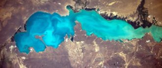
Lake Sasyk-Sivash in Crimea
Full board: 4 water zones, buffet, water parks,
heated swimming pools, animation.
Price from: 1875 rub. / person in June with full board
The sunny peninsula is rich in natural wonders. One of them is a salty estuary reservoir located between the resorts of Saki and Evpatoria. Lake Sasyk-Sivash in Crimea seems to have absorbed the entire palette of red and pink shades; this place is a real gift for lovers of artistic photography. And its silt and brine are not inferior in healing properties to the mud of the Dead Sea. People come here to relax, improve their health and take bright pictures.
Lake Sasyk-Sivash: photo, description
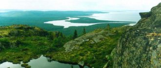
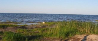
The largest salt reservoir in Crimea stretches 14 km in length and a width of 5 to 9 km. The average depth is 0.5 m, the maximum is 1.5 m. The banks are mostly flat, and only in the eastern part they are steep and steep. It occupies an area of 75 sq. km, but on hot summer days, as the water evaporates, it becomes shallow and smaller. The lake is divided by a dam stretching across the entire Sivash from west to east. A collector was installed at the border to prevent storm water from entering the southern part, which is famous for its healing brine and mineral silt deposits.
The northern one is fresher, rich in vegetation. It was chosen by swans, who previously stayed only for the winter. All year round you can see graceful snow-white beauties and gray, still clumsy young animals there. Mallards, cormorants, and pochards also nest there. Swans are not afraid of people and willingly accept treats from them. During the season, local residents organize mobile cafes where they also sell food for birds. It’s easy to take stunning photos with beautiful birds here, for which Sivash in Evpatoria is called Swan Lake.
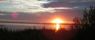
In the southern part, the water has a high content of salt and minerals. The microalgae Dunaliella salina that live here produce beta-carotene, which contains a reddish pigment. As the water evaporates in the hot months, Sivash acquires a fantastic pink, and sometimes crimson or scarlet hue. The lake looks especially impressive at sunset and sunrise, when the landscape is painted in all the shades of the red spectrum. When calm reigns, travelers sometimes observe how in certain areas the water seems to boil: these are underground fountains that come to life. Locals call them griffins.
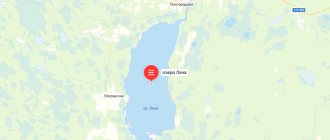
Geographic coordinates of Lake Sasyk-Sivash on the map of Crimea: N 45.195388, E 33.487605.
Lake Sasyk
is located near Evpatoria, between the cities of Saki and Evpatoria. The further from Evpatoria, the smaller and saltier the lake becomes, the closer, the fresher and more diverse in flora and fauna. The main tourist season on the lake begins at the end of July and lasts until the end of September. It is at this time that the lake turns pink, sometimes burgundy and red. From mid-August, the industrial collection of pink salt begins from the village of Pribrezhnoye. And yet there are places where you can take a photo or simply enjoy the unusual natural beauty of Sasyk.
Some general information about Lake Sasyk
Area of Lake Sivash
– 75.5 km2; lake length – 14 km; width – in some places from 5 to 9 km; depth is about 0.5 meters, in some places it reaches 1.5 meters. The lake's name translates to "smelling mud" or "smelling mud". The lake received this name in the 14-15th century from the Turkic tribes. The reason for this name, most historians believe, was the partial drying out of small areas of the lake in summer. After the water evaporates, peat remains on the surface along with the remains of marine life, which give off a fetid odor, especially closer to the city of Saki.
A little history about Lake Sasyk
Some of the first excavations near the shores of the lake showed the presence of people in these places, dating back to the 3rd-2nd century BC. The first mentions of the lake come to us from Tauride Chersonesus, now the city of Sevastopol. It was the ancient Greeks who began to use the salt of Lake Sasyk-Sivash as a preservative for storing fish and meat, as evidenced by clay amphorae and fishing tools found near the lake. In the 16th century, the lake gained great popularity due to salt production and was included in the Chumatsky Way or Izyumsky Way, along which the Cossacks transported salt to Tsarist Russia. In the 19th century, salt from Lake Sasyk-Sivash was distributed throughout the neighboring countries: Turkey, Bulgaria, Syria, Georgia, Hungary, etc.
Beneficial properties of salt on Lake Sasyk
The reason for such a massive distribution of Evpatoria salt was its composition. He is truly unique. Salt includes: zinc, copper, potassium, sodium, manganese, iodine, b-carotene, iron and other rare components - and the taste of salt only benefits from this. Nowadays, iodine and b-carotene are artificially added to expensive varieties of salt, but their properties and digestibility by the body are very questionable and mostly serve as a marketing ploy. B-carotene and iodine, which are included in the salt of Lake Sivash, are of natural origin, being a product of the vital activity of microalgae, which, under the influence of the sun, colors the lake pink or red.
The second important component of the lake is brine, which is also called healing mud. The brine of Lake Sivash contains almost the entire periodic table. Even the ancient Greeks appreciated the healing properties. The most common treatment was relaxation on the lake with a mud wrap. These procedures contributed to the healing of wounds, improved the general condition of the body, treated joints, and rejuvenated the skin. The brine of Lake Sasyk-Sivash has not lost its usefulness to this day. Many medical sanatoriums on the Crimean coast have included it in complexes for rejuvenation and treatment of complex skin diseases.
Fishing on Lake Sasyk near Evpatoria
Fishing on Lake Sasyk-Sivash
– perhaps one of the best lake fishing trips in Crimea. Here you can catch both river and sea fish. The northern part of the lake is fresh. The most common fish species in Lake Sasyk-Sivash are: perch, crucian carp, mullet, carp, horse mackerel, rarely carp and many other fish species. The best time for fishing: late spring and early autumn. The main bait used for fishing is estuary worm or shrimp, but various mixtures are also used. Bait for fishing can be bought in Evpatoria in almost every specialized fish store. The estuary worm is sold in paper or rag packages.
Swans on Lake Sasyk
The highlight of Lake Sivash
swans began to appear in Evpatoria. They live on the lake all year round. They immediately hatch their offspring, teach them to fly, and repeat their cycle every year. Swans have become part of the city's cult. In winter, even in the harshest weather, when leaving the city, you can always meet several cars stopping to feed the swans. The flocks of swans have long been joined by several species of ducks, gulls and cormorants. In the summer, when you stop to feed the swans, you may not be able to find the bread. The swans are so fed that they are very busy with the offerings. Taste preferences are closely monitored by an on-duty machine with tea, coffee and seasonal drinks, standing all year round at the swan feeding site.
How to get to Lake Sasyk
Get to Lake Sasyk-Sivash
very simple.
It stretched from the outskirts of the city of Saki to the outskirts of the city of Evpatoria. The most convenient approaches are from Yevpatoria: you drive up to the beginning of the beaches, the road goes to the right through a railway crossing, immediately after the railway crossing you can turn right, leaving the main road; or follow the main road, you will have a lake on both your left and right. If you decide to get to the most colorful part of Lake Sasyk - its pink part - then you should get to the Banana Republic water park, immediately after it (if you move from Evpatoria), there will be a left turn towards the village of Pribrezhnoye, passing a tunnel under the railway. drive out to the first building (school), in front of it the road will turn left again (dirt), you go there, another 20-50 meters and you are at your goal. Lake Sasyk-Sivash is one of the most beautiful natural attractions of the Crimean Peninsula. When you come to Evpatoria on vacation, Lake Sivash is a must-visit, along with the Gezlev Gate, the water park “At Lukomorya”, the Karaite Kenas and the central embankment of the city. If you love fishing and have tried sea fishing, be sure to visit Lake Sivash in Evpatoria. Lake Sasyk-Sivash on the map of Crimea
Location on the map, how to get there
The reservoir is located on the western coast of the peninsula, east of Yevpatoria. It is separated from the sea by a strip of land 0.9–1.7 km wide. A railway and a highway run along the isthmus, connecting Saki with Yevpatoria.
GPS coordinates: 45°11'57″N 33°24'22″E.
You can get to the lake by electric train, getting off at the “54th kilometer” station. Electric trains depart from Simferopol and Dzhankoy and pass through large settlements - Komsomolskoye, Gvardeyskoye, Saki. To get to the banks of the Sivash from Yevpatoria, you just need to take public transport to Simferopolskaya Street and walk 0.5 km. You can take an intercity bus to Pribrezhnoye and walk through the village towards the lake.
The route by car from Simferopol will be 60 km along the R-25 highway through the villages of Aeroflotsky, Skvortsovo, and Pribrezhnoye. Travelers from Sevastopol will need to travel 105 km along the N-06 highway, pass Inkerman, Orlovka, Razdolye, turn off at Chebotarka onto R-25 and move west to the lake shore.
How to get to Sivash
Sivash is located between two seas - the Black and Azov, east of Yevpatoria. Now this “salt pearl” belongs to Russia. In the recent past, the geographical location of the water body was Ukraine. Lake Sivash is long, so it can be reached from many directions. An alternative route by personal transport is driving along the Moscow-Simferopol highway towards the Crimean capital. In the Kherson region, Genichesk district, in the village of Novoalekseevka, you need to turn off and move towards Genichesk. When entering the city, turn onto the Arabat Spit. Lake Sivash is a kind of border. Crimea borders in this place with the Kherson region.
You can drive along the highway to the Chongar Peninsula. In this place there are three villages - Chongar, Ataman and Novy Trud. A couple of kilometers from each is Sivash Bay. Those who come here to relax should remember that Sivash is a small local resort that is by no means of international importance, and there is no need to be afraid of the lack of smooth roads and comfortable living conditions.
The history of Sasyk-Sivash, interesting facts
The reservoir is of estuary origin. In ancient times, it was a Black Sea bay, but storm waves and winds over the centuries formed a sand and shell bar, which turned Sasyk into an endorheic lake. The name was given to it by the Crimean Tatars, it means “stinking mud”. The reason for this was the characteristic hydrogen sulfide smell emanating from the reservoir. Contrary to the dissonant name, Sivash is a real storehouse of healing mud and brine, the reserves of which reach 2 billion cubic meters.
Unique pink salt crystals have been mined on the lake since ancient times. This was confirmed by clay vessels found by archaeologists that were used to preserve fish. This seasoning was worth its weight in gold. Since the 15th century, Sasyk-Sivash served as one of the main sources of salt production for the Moscow Principality, and later for the entire Russian Empire.
The route of the caravans passed along the Izyumsky Way, and often the merchants were attacked by robbers - “rose gold” was considered an expensive commodity, and the robbers were not averse to profiting from it. In the 19th century, Evpatoria salt was exported to neighboring countries. In 1912, at the Paris Exhibition, it was awarded the first award for the highest quality. The composition of the salt mined at Sivash includes:
What attracts tourists to Sivash?
The lake waters have unique healing properties - this is the most common reason for visiting it by a large number of people who come here for the sake of recovery.
These irreplaceable qualities are acquired due to the peculiarities of the local dry and hot climate, which during periods of summer heat reaches temperatures up to +40 °C, and often higher. With such heat, the fresh water in the lake, which is practically unfed by anything, evaporates, leaving a thick brine rich in salts (salinity in some parts ranges from 20 to 90%).
Bromine, sodium, magnesium, potassium, chlorine and other chemical compounds formed in large quantities are added to salt. The local water also contains provitamins A - carotene, present in considerable quantities in carrots, secreted by the smallest crustaceans, the only living organisms here. This component, accumulating in the waters of Sivash, colors them in an amazing, unusual color - from crimson to bright orange, giving it that same charm. All components and compounds form healing mud and brine, which is extremely beneficial for the skin and body - something for which thousands of people visit the reservoir.
Lake Sasyk-Sivash in Crimea: a source of sulfide healing mud
Sludge deposits and brine, saturated with hydrogen sulfide and minerals, are used in the treatment of various diseases:
— pathologies of the musculoskeletal system; - endocrine and nervous disorders; — digestive and metabolic disorders; - dermatological problems.
In health resorts and cosmetology clinics, Sivash brine is part of rejuvenating complexes. Sea air saturated with iodine is useful for weakened immunity and respiratory diseases, so even walks along the lake shore will be beneficial. However, mud therapy has limitations and contraindications; it is not recommended to practice it without consulting a doctor. The duration of procedures should not exceed 10–15 minutes.
What a tourist needs to know
The swimming season on Sasyk-Sivash can be opened as early as May: due to its shallow depth, the lake quickly warms up. The increased concentration of salt gives the water amazing properties - it easily holds a person and literally pushes him to the surface, preventing him from completely submerging.
Travelers who dream of admiring all the shades of the pink palette are better off coming to Sasyk in July – August. At the height of summer, as the water shallows, the color of the water becomes brighter and more saturated. At this time, you will get the most amazing pictures, where the crimson surface of the lake on the horizon merges with the azure sky.
Fans of fishing prefer May and September. On the northern shore there are mullet, carp, crucian carp, and horse mackerel. The bait is shrimp and estuary worms. According to tourists, the bite on Sasyk-Sivash is excellent; this lake is considered one of the best in Crimea for fishing.
What to see in the area
The reservoir is located within walking distance from Yevpatoria with a well-developed infrastructure, and there is a wide choice of leisure activities here. Interesting to visit:
— the temple complex “Karaite Keras” with a museum located next to it; - Gözlev Gate; - Church of St. Elijah; — Krasnaya Gorka memorial; - arboretum; — “House of Wine” with a tasting room and a shop; — local history museum; — exhibition “Crimea in Miniature”; — Moinak Lake, located within the city limits.
Children will love the Evpatoria Zoo, Dolphinarium, and Oceanarium. A small aqualand “At Lukomorye” will be an excellent place for a family vacation. And 9 km from the city lies the largest water park on the peninsula, Banana Republic, with many exciting water slides.
A trip to Sasyk-Sivash will give you unforgettable impressions and amazing photos, and the golden beaches located nearby will delight both adults and children. Tourists will find entertainment for every taste, and at sunset you can take fabulous pictures of the lake.
Turquoise, pink or blue: top 5 most fantastic lakes in Crimea
Arriving in Crimea, many do not know that in addition to the Black Sea, there are a lot of beautiful and unusual lakes on the peninsula. People who are looking for bright emotions and adventures should definitely visit there.
№1 Turquoise Lake
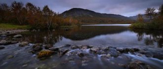
It is located near the village of Zaprudnoye. It was called turquoise because of the color of the water. It is clean, but quite cold, because the reservoir is formed by springs. If you want, you can swim in the lake, but you should prepare for a sharp change in temperature. In addition, you can have a great time there, if you wish, go fishing or take a walk in the forest, where many medicinal herbs grow.
The closest way to get to your destination is from Alushta or Yalta by trolleybus No. 53 to the Partenit stop. You will have to walk to the village of Zaprudnoye, and from there it’s a short walk to the lake; the journey will take about an hour.
No. 2 Lake Sasyk-Sivash
The pink lake Sasyk-Sivash is the most unusual and fascinating in its beauty. Salt accumulates in its southern part, so the water turns pink. Sasyk-Sivash was formed back in the Ice Age. As geographers say, it used to be a sea bay, and later, due to a sand spit, it separated. The most unusual thing about it is that the northern half of the lake became fresh, and the southern half was covered with a dense shell of salt. By the way, from the Crimean Tatar language Sasyk-Sivash is translated as “stinking mud”. Because the reservoir emits a pungent odor of hydrogen sulfide. To admire the unusual pink color of the lake, it is better to go there in May; in July and August it turns red-orange. The pond acquired such a bright color due to the bacteria “Dunaliella salina”, which densely settled in it.
Geographical location and features
Salty Bay of Sivash
The salty Bay of Sivash , which is often also called Lake Sivash, is the natural border between the south of the Kherson region on the Ukrainian mainland and the northeastern coast of the Crimean peninsula. In the west it is separated by the narrow Perekop Isthmus from the Black Sea, in the east by an alluvial spit of natural origin, the Arabat Strelka, from the Azov Sea.
The bay itself, in turn, is divided into eastern and western parts by the shallow Chongar Strait , the width of which narrowed noticeably after the construction of the railway bridge in 1873. The embankment dam erected at the same time, connecting the Crimean coast of Sivash with the Chongar Peninsula of mainland Ukraine, actually divided the reservoir into two separate basins . In the western part there is the Middle, or Central, Sivash (near the Chongar Strait), and in the eastern part - the Southern Sivash (south of the Shakalinsky narrowing and the mouth of the Salgir River).
Due to periodically flooded tracts, the so-called “droughts,” on the western and southwestern coasts of Sivash, the water surface area of the bay ranges from 2400 to 2700 sq. m. km. The total area of areas that are periodically covered with water is more than 500 square meters. km. Another about 100 sq. km. falls on the islands. In fact, Sivash is a whole system of 11 salty and bitter-salty bays with several large and dozens of small islands, as well as lakes-lagoons and fresh water bodies in its coastal areas. The length of the entire western part is about 80 km, with a width from 5 to 20 km. The eastern part of the bay stretches for almost 120 km, with a width ranging from 2 to 35 km and the widest section in the north near Rogozinsky Bay.
The average depth of Sivash does not exceed a meter , with a maximum depth of 3.2 meters . At the same time, the Eastern reservoir is deeper, with meter depths found on 40% of the area versus only 18% in Western Sivash. The deepest areas are located in the central part of the Southern Reservoir.
Strait "Thin"
The bay is fed by the waters of the Sea of Azov , with which Sivash is connected by the Genichesk (“Thin”) and Promoina straits near the northern tip of the Arabat Spit, seasonal precipitation , as well as the Crimean rivers Salgir, Indol, Churuksu, flowing into it, several smaller rivers and underground sources. Sea water, which enters through filtration through the Arabat Strelka, has virtually no effect on the water supply of the bay. Due to the prevailing shallowness and strong evaporation in the summer, the water in Sivash is highly mineralized, the salinity in some lagoons reaches 200%. At the same time, the Eastern reservoir is deeper, the prevailing depths are 1–2 meters, and it is fresher compared to the Western one.
The complex orography of the Sivash coastline, indented by bays and capes , shallow water and difficult water exchange with the Sea of Azov turned the bay into a giant natural evaporator, which contributed to the creation of huge reserves of mineral and balneological resources. Unique natural evaporative habitat for rare species of birds and plants .
In the second half of the twentieth century, after the launch of the North Crimean Canal, there was a gradual desalination of the eastern part of the bay, into which water was discharged both from the canal and from the drainage systems of Eastern Crimea. If in 1950 the salinity of the water area of Eastern Sivash varied from 13.3–35.5% in the area of the Tonky Strait to 139.0–155.9% in the south near the Arabat fortress, then studies in 2003–2004 showed salinity in the same areas - 12.5–14.4% and 21.7–26.0%. According to researchers, now the Eastern Sivash is moving into a conditionally natural state, with a gradual decrease in its volume and salinization due to the increased influx of sea water from Azov.
Strait "Promoina"
As for Western Sivash, after a detailed study of the chemical composition of its brine in the first half of the twentieth century and the development of the chemical industry in the region, the reservoir was actually turned into technological storage pools , which are used for the extraction of raw materials and the discharge of industrial waste .
Eastern Sivash
Eastern Sivash , including its southern part, occupies over 60% of the total area of the bay and stretches from the Arabat Spit in the east to the Biyuk-Naiman dam in the west. The total area of the water surface is approximately 1400 square meters. km. The banks of the eastern part are mostly wide and flat, with a marshy bottom and a smooth entrance to the water. Only in the area of the former farmstead “Valok” , due to the geological features of the area, the shore of the bay is high and steep.
The so-called “droughts” - coastal areas of the bottom periodically covered with water - are also characteristic of Eastern Sivash. These are large and flat areas with dense, powerful silt deposits, which are filled with brine only during surge winds. In the northern part of the reservoir there are islands , the largest and most famous of them are Papanin (Kuyanly) , China , Kuyuk-Tuk . The Sivash Islands are a nesting and habitat for many birds, including Red Book species.
Sivash
The deepness of the Eastern Sivash in fact means the dominance of depths up to a meter , with areas up to 2–2.5 meters deep only in the center of the Southern reservoir. There, in the south, the greatest depths of up to 3–3.2 meters were recorded.
The Eastern Reservoir also has its own currents: sea water flows through the Tonkiy and Promoina straits and moves south and west. During the movement part of it evaporates , due to which the mineralization of the bay increases . That is why the initial salinity of the southern part of Sivash was much higher than the northern one, before human intervention in the natural process. During the operation of the North Crimean Canal, the volume of fresh water that was discharged into the bay exceeded evaporation by one and a half times. In fairness, it is worth noting that as soon as the discharge decreased, the salinity of Sivash tended to return to its normal level.
Sivash Islands
Eastern Sivash is replete with small and not so small islands , most of which are uninhabited . An exception to the rule is the largest island of the bay - Papanin , with an area of more than 1000 hectares, which is located in the northern part of the reservoir and, according to legend, was once connected by a bridge with the Semenovsky Kut peninsula.
Papanin Island
Papanin Island (old name - Kuyanly ) is of mainland origin and is unique in that it has its own sources of fresh water, quite suitable for drinking. Until the 70s of the twentieth century, people lived on it; later, residents from the “mainland” grazed cattle in the local meadows. Now the island is completely uninhabited , it is visited only by tourists. Papanin is especially beautiful in the spring, when the steppe begins to bloom.
Several more Sivash islands are known as bird nesting sites:
- China , between the Perekop Isthmus and the Chongar Peninsula - a part of the land that was located about 900 years ago on the site of the modern Sivash Bay. A protected area where rare birds such as the Caspian martin and the Caspian mallard nest;
- Kuyuk-Tuk , to the west of the village of Chongar in the Genichesk region, is an island of mainland origin, which is separated from the Chongar Peninsula by a strait. The protected part of the island belongs to the Azov-Sivash Natural Park and is where the Gesner tulip grows. The steep eastern shores are a nesting place for the shore swallow, shelduck, and common bee-eater;
- Martynyachiy , in the central part of the bay - occupies an area of about 5 hectares, on which the silver martin, gray duck, roller, and other birds nest. It is part of the Azov-Sivash Natural Park.
For lovers of green tourism, the areas of virgin steppes preserved on the islands, which are covered in spring with a carpet of blooming tulips and irises, .