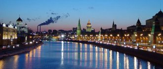
Location
The state is located between the Sea of Okhotsk and the Pacific Ocean. The area is 377 thousand square meters. km. If we talk about coordinates, Japan lies 36 degrees north of the Equator and 136 degrees east of the Greenwich meridian. The largest islands of Japan are:
- Kyushu;
- Shikoku;
- Honshu;
- Hokkaido.
Japan has no land borders with other countries. The coastline of the state stretches for 29,751 km .
The border of the country, washed by the sea, is parallel to Russia, China, and the Republic of Korea.
Southern Islands
The Southern Islands of Japan usually include the Ryukyu Islands, located to the southwest of the main part of the country, the Bonin Islands, located in the Pacific Ocean, at a distance of 1000 km from Tokyo, and the most remote island of Minamitori.
Bonin Islands
is a group of 41 islands located between the Mariana Islands and Japan south of Tokyo. The total area does not exceed 104 square kilometers, the total population is about 2,500 people. There is a Japanese naval base on the southern island of Yojima.
Ryukyu Islands
is a group of 98 islands stretching 1,200 kilometers in the East China Sea from Kyushu to Taiwan and having a total area of 4,700 square meters. km. Currently, only 47 of them have a permanent population. The total number of inhabitants is 1.6 million people, 90% of whom live on the largest island - Okinawa. The most developed sectors of the economy are agriculture, fishing and tourism.
Minamitori
- the easternmost island of all that belonged to Japan. Minamitori has an area of 1.2 square kilometers and has no permanent population. Despite this, the island is of great strategic importance to the country, as it allows Japan to claim 428,875 km² in the surrounding waters.
Relief
Due to its geographical location, Japan has many slopes and mountain ranges. The terrain is mountainous, and most of the mountains are too dissected. Relief features also include the predominance of angular contours. On the islands of Kyushu and Honshu there are smoothed features, the coastal areas of Hokkaido are distinguished by the softness of the relief.
The highest mountain is Fuji. It is located in the center of the island of Honshu, west of Tokyo. Some peaks of this mountain reach a height of 3000 meters above sea level.
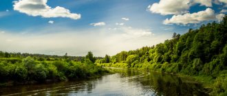
In the state, only 25% is occupied by plateaus and lowlands. There are also a huge number of reservoirs and rivers on the territory, which complicates the construction of urban infrastructure.
The longest river is the Shinano. It reaches 367 km in length.
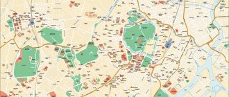
Map of Japan in Russian
Japan is an amazing country. It's like a completely different world. Separate from us, different. Traditions, culture, architecture, life - absolutely everything is different. But let's take things in order. Hills and mountains make up over 75% of Japan's territory. Lowlands are located only along the coast. Japan's climate ranges from cold in the north to sub-tropical in the south. About 60% of the country's territory is covered with forests, about 700 species of trees and shrubs are found in the country's nature and almost 3,000 different herbs. The fauna of Japan is not so rich, but it has its own unique and unique natural species. More than 600 species of fish live in the seas washing the shores of Japan. The sprawling network of islands is of interest to tourists, as many of them are suitable for tourism purposes.
Map of Japan in Russian The map can be enlarged or reduced
(Use the navigation icons to navigate and zoom in on the map)
Map of Japan from satellite
The most interesting culture is Japan. Its peculiarity is that it developed for a long time in complete isolation from the rest of the world.
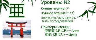
An important part of Japanese culture is their unique language of hieroglyphs, which reflects the soul and heart of the Japanese people, their experiences and emotions - this is a complex interaction of three types of writing hieroglyphs. The language of this country is considered one of the most difficult to learn.
For the Japanese, the sculpture and literature of their country are also very important; many tours carefully dwell on these topics and explore all the deep historical processes reflected in Japanese literature. Fortunately, there are a large number of museums, memorable places and interesting attractions for this. And for Japanese painting, as well as for literature, nature is very important, since in nature the Japanese see a reflection of the divine principle.
Japanese theater is also completely unique. The use of unusual ways to express an image - masks, clothes and makeup - causes genuine delight among many tourists. Visual and musical accompaniment are also most often used in the theatrical life of Japan.
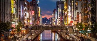
For popular culture, such areas of Japanese culture as anime and manga are known. Anime is a type of Japanese animation with its own laws and customs, aimed more at an adult audience. Manga are Japanese comics that have an original approach to the expression of certain images and storylines. It also applies more to an adult audience, as it often poses non-childish questions to the reader.
To fully experience Japan, it is important to visit there, because it is impossible to describe the wonderful taste and smell of Japanese tea drinking. Just like you can’t experience Japanese cuisine just by chewing a few sushi. This is much deeper and more interesting than it seems.
The traditions and customs of the Japanese cannot be depicted. Their behavior is dictated by rituals and special morals coming from the past. The Japanese instantly stand out from the crowd because they live a life completely separate from the rest of the world.
It's hard to say what surprises most in this country. Insanely beautiful temples of truly unusual shapes, the foot of Mount Fuji or Japanese cuisine - everyone will decide for themselves, plunging into all the diversity and originality that this amazing country gives us.
______________________________________________________________________
Ultimately, why are we drawn to other countries? Because there is beauty there. Beauty that we don't have. Special. Original. And in Japan there are a lot of original things that surprised both a hundred years ago and now.
Natural features
The country is characterized by a temperate and subtropical climate. Hokkaido and the northern part of Honshu are under the influence of moderate air masses, and the islands in the south of the country are in the subtropical zone. An impressive part of the land is occupied by broad-leaved evergreen forests. In the north of the republic there is predominantly taiga, and in the south there are mixed forest zones.
There are small coal deposits on the island. There are also frequent deposits of oil and mineral resources. In addition, the republic has large deposits of sulfuric acid.
Major islands of Japan
Honshu
. The largest island of the Japanese archipelago, previously also known by such names as Hondo and Nippon, accounting for 60% of the area of the entire country. The length of the island is 1300 kilometers, the width ranges from 50 to 230 kilometers. About 100,000,000 people live permanently on Honshu. Major cities such as Tokyo, Osaka, Hiroshima, Kyoto, Yokohama are located here. The symbol of Japan is Mount Fuji, also located on Honshu.
Hokkaido
. Also known in the past as Ezo, Ieddo, Iesso, Matsumae. The second largest island of Japan, separated from Honshu by the Sangar Strait. In total, about 5.5 million people live here; famous cities include Sapporo, Chitose, and Wakkanai. Since the climate on this island is noticeably colder than in the rest of the country, among the Japanese themselves, Hokkaido is considered a “harsh server”. Despite the fact that geographically most of the settlements are located south of Paris, the climate is very different from European.
Kyushu
. The third largest island of Japan, according to some sources, considered the birthplace of Japanese civilization. Currently, there are such large cities as Fukuoka, Nagasaki, Hirado, Oita, Kagoshima and Kumamoto, the total population of Kyushu is about 12 million people. In the northern part of Kyushu, industry is highly developed, especially chemical and metalworking, and in the south - agriculture and cattle breeding.
Shikoku
. The fourth largest Japanese island, home to about 4 million people. Most of the major cities and population are concentrated in the northern part of Shikoku. The most famous cities include Matsuyama, Tokushima, Kochi, Takamatsu. Shikoku is known throughout the world for its 88 pilgrimage temples, which are associated with the activities of the legendary Buddhist monk Kukai. Heavy engineering and shipbuilding are developed in the northern part of the island, and agriculture is developed in the southern part. However, despite this, Shikoku makes a very small contribution to the country's economy - no more than 3%. In addition, the problem of population aging is more pressing here than anywhere else in Japan. Because young people are actively leaving for Tokyo, Osaka and other large cities of the country.
Sea ports
Answering the question where Japan is on the world map, we found out that it is a maritime country, which means ports play the most important role in its life and economy, because most of the cargo is delivered by sea. Also, almost all exports are carried out by sea. In addition, the state has a fairly large fishing fleet.
There are six largest ports here:
- Kitakyushi - specializes in Asian cargo turnover.
- Kobe is the world's largest port, with flights to more than 500 ports around the world.
- Nagoya specializes only in international cargo transportation.
- Osaka - ferries, container traffic and passenger traffic are concentrated here.
- Shimonseki - here the main specialization is trade flights.
- Tokyo has a universal specialization, accepting both cargo and passenger ships.
Features of the geographical location
The islands are dominated by mountainous terrain. There are many volcanoes, both extinct and active. The entire territory of the country is located at the junction of several tectonic plates. Because of this, there are so many volcanoes on the islands and earthquakes often occur.
It is worth noting: there can be up to one and a half thousand moderate earthquakes here per year.
In modern and recent history, three strong earthquakes with a magnitude greater than 7 are known. Such earthquakes are also dangerous because they can cause a tsunami, which happened in March 2011.
One of the largest volcanoes is Fuji. Its conical outlines are well known even to those who have never been to the country. Even though Fuji is an active volcano, the mountain itself is revered as a sacred place. Fuji is the private property of a Shinto shrine and a place of pilgrimage for representatives of not only Shinto, but also Buddhist cults. This place is also very attractive for tourists.
Despite the fact that there are so many mountains and active volcanic activity, the region is very poor in mineral reserves.
The country's island position made it quite isolated from Western influence during the period of the Great Geographical Discoveries. When they first encountered strangers, the Japanese completely closed themselves off from the outside world and maintained this isolation until the mid-19th century.
When is the best time to go to Japan?
It is better to link the time to visit the country directly with the purpose of the visit. And that's why.
The Japanese climate is temperate (except on the island of Hokkaido), with four distinct seasons and two rainy seasons, characteristic of spring and autumn.
During the winter months, temperatures in Japan are usually above freezing and the weather is dry and sunny.
The height of spring is marked by cherry blossoms from late March to early April and has a special name - “Hanami” or “Cherry Blossom Festival”. Tourists from all over the world come to see the blooming beauty.
Good things come to an end; Japanese summer begins with the rainy season. It is also called “bayou” or “plum rain”. This period lasts several weeks, after which the real summer heat sets in and is a paradise for beach lovers.
In autumn, the wind becomes fresher, and the temperature is lower and much more comfortable. At this time, travelers come to gain “cultural” impressions and admire the red maples. The season of red maples even has a special name - “momiji”.
The first accurate map of the world was created. What's wrong with everyone else?
How to show the round Earth?
How to align a sphere? For centuries, cartographers have tried to accurately depict the round planet on a plane. It was necessary to create a map that you could put in your pocket and go to conquer new territories, draw routes and generally see the entire territory of the Earth at the same time.
There were many attempts.
On familiar maps the world is shown as it was depicted by the Flemish geographer Gerardus Mercator back in the 16th century. Then he revolutionized cartography, but his projection distorted the real sizes of countries (lines of longitude are located parallel to each other, although in reality they intersect at the poles - as a result, objects at the poles are much larger in size than those at the equator).
However, it is impossible to do everything perfectly. A map that does one thing well may not do another. The popular Mercator projection, which hangs on all classroom walls and is used as the basis for Google maps, is excellent at depicting local shapes, but it distorts areas of the surface near the North and South Poles so much that the polar regions are usually simply cut off.
You can evaluate this distortion on the True Size map: you need to select any country, move it to another continent and compare the scales. For example, on a classic map Russia looks many times larger than Africa, but in reality it occupies only half of the continent.
It's the same with Greenland, which appears to be twice the size of Australia, but in fact only occupies a third of its area. China, in turn, occupies much more area than it seems.
Attempts to adapt
Of course, after the creation of the Mercator projection, scientists tried to make as plausible an adaptation as possible. How to determine the ideal one? In 2007, a system was created to evaluate existing maps. It quantifies six types of distortion introduced by planar maps: local shapes, areas, distances, bending, asymmetry, and boundary cuts (discontinuities). The lower the score, the better: a globe, for example, has a score of 0.0. The authors of the system are J. Richard Gottom, professor emeritus of astrophysics at Princeton and creator of the logarithmic map of the Universe, and David Goldberg, professor of physics at Drexel University.
In 1921 , the German cartographer Oswald Winkel proposed a modified azimuthal projection of the world map - the Winkel tripel projection lll. It is the best known of the previously proposed planar map projections. Name tripel
(German for "triple") refers to Winkel's goal of minimizing three types of distortion: area, direction, and distance.
The Winkel Tripel projection, chosen by National Geographic for its world maps, represents the poles more accurately than Mercator, but still greatly distorts Antarctica and creates the illusion that Japan is much east of California rather than its nearest neighbor.
West. Goldberg-Gott Score: 4.563 Credit: Map by Daniel R. Streb, Wikimedia Commons Her Goldberg-Gott score is 4.563. Already close to zero, but there was still the problem of “crossing borders” - dividing the Pacific Ocean and creating the illusion of a long distance between Asia and Hawaii.
The attempts continued.
In 1943 , Buckminster Fuller tried to make a map that would reliably convey the size of the continents. He broke the round Earth into regular shapes and gave instructions on how to fold and assemble the globe into a polyhedral globe. Although Fuller thus protected the shapes of the continents, he shredded the oceans, and many between continents grew larger, for example, between Australia and Antarctica.
Buckminster Fuller popularized the polyhedral "Dymaxion" projection based on the unfolded icosahedron. Antarctica is "round, as it should be," Gott said, but this projection "breaks up" the oceans. Goldberg-Gott score: over 15. Credit: NASA Earth Observatory, with modifications by Mapthematics LLC.
It is clear that a completely new approach is needed.
New approach
A fundamental rethinking of how maps could work resulted in the most accurate flat map ever made. Three experts contributed to the project: J. Richard Gottom, David Goldberg, and Robert VanderBey, a professor of operations research and financial engineering who created the "Purple America" election map.
2021 Presidential Election Results Source: vanderbei.princeton.edu/JAVA/election2016
Scientists were inspired by Gott's work on polyhedra—multi-faceted solid figures. In a recent paper, he began to consider a new kind of polyhedra with regular shapes, which led to the revolutionary idea of a double-sided map.
Talking about the new flat map, the professor recalled the story of the Olympic high jumpers. In 1968, Dick Fosbury shocked sports fans by arching his back and jumping backwards over the bar. He set a new record and won the gold medal, and since then high jumpers have changed tactics.
“We’re like Mr. Fosbury,” Gott explains. “We’re doing this to break the record, to make a flat map with the least possible errors.” So, like him, we surprise people by offering a radically different type of card. Each of Winkel Tripel's mistakes was taken into account."
The new map is unlike any of the previous ones.
Solution found
The flat map that scientists created is double-sided and round, like a gramophone or vinyl record. It goes beyond two dimensions without losing the logistical convenience - storage and production - of a flat map.
Credit: Video by J. Richard Gott, Robert Vanderbey and David Goldberg.
The new double-sided map has fewer distance errors than any single-sided flat map. The previous record holder was a 2007 map created by Gott with Charles Mugnolo, a 2005 Princeton graduate.
In fact, this map is notable for having an upper bound on distance errors: distance deviations of more than ±22.2% are not possible. By comparison, in the Mercator and Winkel Tripel projections, as well as others, the distance errors become huge as you approach the poles and are essentially infinite from left to right (which are far apart on the map but directly adjacent to the globe) . In addition, the area at the edge is only 1.57 times larger than at the center.
The map can be printed front and back on one magazine page for the reader to cut out.
Buckminster Fuller popularized the polyhedral "Dymaxion" projection based on the unfolded icosahedron. Antarctica is "round, as it should be," Gott said, but this projection "breaks up" the oceans. Goldberg-Gott score: over 15. Credit: NASA Earth Observatory, with modifications by Mapthematics LLC.
As far as scientists know, no one has ever made double-sided maps of such precision before.
Read more
Unknown sponge-like animals found in the ice of Antarctica
The Brunt Shelf in Antarctica is being destroyed at a rate of 5 meters per day
Abortion and science: what will happen to the children they give birth to?